geo.wikisort.org - Island
Raivavae (Tahitian: Ra‘ivāvae [ra.i.va:va.e]) is one of the Austral Islands in French Polynesia. Its total land area including offshore islets is 17.9 km2 (6.9 sq mi).[1]: 205 At the 2017 census, it had a population of 903.[2] The island is of volcanic origin, and rises to 437 metres (1,434 ft) elevation at Mont Hiro.[1]: 243
Raivavae | |
|---|---|
Commune | |
 NASA picture of Raivavae island | |
 Flag | |
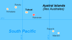 | |
Location of Raivavae  | |
| Coordinates: 23°52′09″S 147°39′49″W | |
| Country | France |
| Overseas collectivity | French Polynesia |
| Subdivision | Austral Islands |
| Area 1 | 17.9 km2 (6.9 sq mi) |
| Population (2017) | 903 |
| • Density | 50/km2 (130/sq mi) |
| Time zone | UTC−10:00 |
| INSEE/Postal code | 98739 /98750 |
| Elevation | 0–437 m (0–1,434 ft) |
| 1 French Land Register data, which excludes lakes, ponds, glaciers > 1 km2 (0.386 sq mi or 247 acres) and river estuaries. | |
History
The first sighting by Europeans was recorded by the Spanish naval officer Tomás Gayangos on board of the frigate El Aguila on 5 February 1775. Gayangos had taken over the command of the expedition of Domingo de Bonechea of 1774 after his death in Tahiti and was returning to the Viceroyalty of Peru.[3] The main source describing this sighting is that of José Andía y Varela, pilot of the packet boat Jupiter that accompanied El Aguila in this return trip. On 6 February, a boat was sent in, and made contact with the inhabitants at the shore edge, but landing was not made. Raivavae was charted as Santa Rosa by the Spaniards, who recorded as Oraibaba the name of the island said by the inhabitants.[4][5][6]
It was annexed by France in 1880.
Administration
The islands of Raivavae are administratively within the commune with the same name. Raivavae consists of the following associated communes:[7]
- Anatonu
- Rairua-Mahanatoa
- Vaiuru
See also
- Islands controlled by France in the Indian and Pacific oceans
References
- Environnement marin des îles Australes
- Répartition de la population en Polynésie française en 2017, Institut de la statistique de la Polynésie française
- Salmond, Anne (2010). Aphrodite's Island. Berkeley: University of California Press. pp. 355. ISBN 9780520261143.
- Andía y Varela, José Relación del viaje hecho a la isla de Amat, por otro nombre Otahiti, y descubrimiento de las islas adyacentes en los años 1774 y 1775, Barcelona, 1947, p.83
- Sharp, Andrew The discovery of the Pacific Islands Oxford, 1960, p.126,127
- Corney, Bolton Granvill The quest and occupation of Tahiti by emissaries of Spain during the years 1772-1776, London, 1913, Vol I, p.XLVII
- Décret n°72-407 du 17 mai 1972 portant création de communes dans le territoire de la Polynésie française, Légifrance
Austral Islands of French Polynesia | |||
|---|---|---|---|
| Authority control |
|
|---|
This French Polynesia-related geography article is a stub. You can help Wikipedia by expanding it. |
На других языках
[de] Raivavae
Raivavae, anderer polynesischer Name Vavitu, alte Namen: Laivavai, Lord Bolton´s Island und Santa Rosa, ist ein dünn besiedeltes Atoll im Südpazifik, das geographisch zu den Austral-Inseln, genauer zur Gruppe der Tubuai-Inseln, zählt und politisch zu Französisch-Polynesien gehört.- [en] Raivavae
[es] Raivavae (isla)
La isla Raivavae, también llamada Vavitu, es una de las islas Australes, en la Polinesia Francesa. Está situada en medio del archipiélago, a 195 km al sureste de Tubuai y a 730 km al sur de Tahití.[fr] Raivavae
Raìvavae (de son nom en tahitien, en graphie Raapoto) ou Gagnivavae (de son nom local, en graphie locale)[réf. nécessaire], ou encore Vavitū, est une île située dans l'archipel des Australes (Tūhaa Pae) en Polynésie française.[ru] Раиваваэ
Раиваваэ (фр. Raivavae) — остров в архипелаге Тубуаи (Французская Полинезия). Расположен к югу острова Таити в центральной части архипелага примерно в 195 км к юго-востоку от острова Тубуаи. Площадь — 16 км², а население — 905 человек (2007).Другой контент может иметь иную лицензию. Перед использованием материалов сайта WikiSort.org внимательно изучите правила лицензирования конкретных элементов наполнения сайта.
WikiSort.org - проект по пересортировке и дополнению контента Википедии