geo.wikisort.org - Island
Marotiri is a group of four uninhabited volcanic rocks protruding from the sea (and several submerged rocks), forming the southeastern end of the Austral Islands of French Polynesia. Marotiri is also known as Bass Rocks (Îlots de Bass in French),[2] maybe according to the name of the European explorer George Bass. Marotiri is very isolated,[3] located about 1,167 km (725 mi) west-south-westward of Pitcairn Island.[4] The closest island is Rapa Iti, 75 km farther northwest, but separated from it by an ocean depth of more than 1,500 meters.[5] The rocks are part of the municipality of Rapa.
 Marotiri or Bass Rocks | |
 Marotiri  Marotiri  Marotiri | |
| Geography | |
|---|---|
| Location | Pacific Ocean |
| Coordinates | 27°55′S 143°26′W |
| Archipelago | Australes |
| Total islands | 4 |
| Area | 0.0431 km2 (0.0166 sq mi) |
| Highest elevation | 113 m (371 ft) |
| Highest point | Southern Rock |
| Administration | |
France | |
| Overseas collectivity | French Polynesia |
| Administrative subdivision | Austral Islands |
| Commune | Rapa Iti |
| Demographics | |
| Population | Uninhabited[1] (2012) |
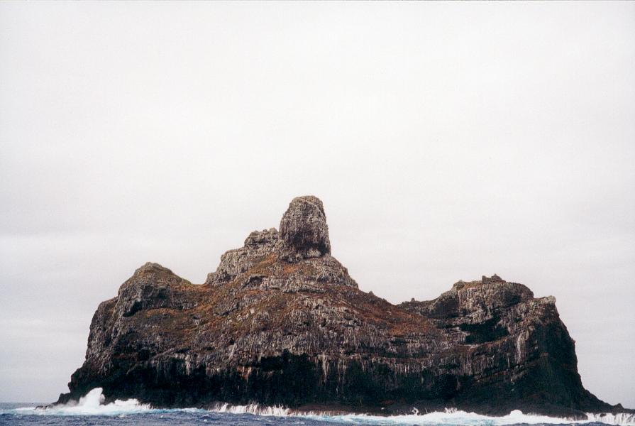
The climate is wet temperate. The lower rocks are almost devoid of vegetation - although there is some vegetation on the upper slopes and summits.[4] They are important as a seabird rookery. Fish abound in the adjacent waters. The rocks emerge from a submarine platform 100 meters deep and 5 km in diameter. They lie at a distance between 1.5 and 3 km from one another. The total land area is 43,100 m2, which is broken down as follows by the individual rocks:
| Rock | Area (m2) |
|---|---|
| Northern Rock | 5,800 |
| Central Rock | 1,800 |
| Southern Rock | 22,400 |
| Western Rock | 13,100 |
| Marotiri | 43,100 |
The southern rock is the largest, with a height of 113 meters at its highest point.
See also
- Desert island
- List of islands
References
- "Population". Institut de la statistique de la Polynésie française. Retrieved 10 January 2015.
- According to the French hydrographic office (SHOM) nautical charts 6607 and 4232.
- International Association of Biological Oceanographers. Committee on Coral Reefs (1985). Proceedings of the Fifth International Coral Reef Congress: Symposia and seminars (B). Antenne Museum--EPHE. p. 90. ISBN 978-2-905630-03-2. Retrieved 22 July 2012.
- Pacific islands pilot. Sold by J.D. Potter. 1969. p. 61. Retrieved 22 July 2012.
- According to the French hydrographic office (SHOM) nautical charts 6607, there is a depth of 1,646 meters midway between Rapa and Marotiri.
Austral Islands of French Polynesia | |||
|---|---|---|---|
This French Polynesia-related geography article is a stub. You can help Wikipedia by expanding it. |
На других языках
[de] Marotiri
Marotiri, auch îlots de Bass (deutsch Bass-Inseln), ist keine singuläre Insel, sondern eine Gruppe von zehn kleinen und kleinsten, unbewohnten Felsen im Pazifischen Ozean mit einer gemeinsamen, untermeerischen Basis. Sie gehört geographisch zum Archipel der Austral-Inseln und politisch zu Französisch-Polynesien und wird von der Gemeinde Rapa verwaltet.- [en] Marotiri
[es] Marotiri
Marotiri, o islotes de Bass, es un grupo de islotes rocosos de las islas Australes, en la Polinesia Francesa. Dependen de la comuna de Rapa, que se encuentra a 75 km al noroeste.[fr] Marotiri
Marotiri est un groupe de quatre îlots inhabités (et de plusieurs roches submergées), à l’extrémité sud-est des îles Australes en Polynésie française. Ce groupe est également connu sous le nom de Cuatro-Coronados mais aussi d’îlots de Bass, vraisemblablement du nom du navigateur anglais George Bass qui les aurait découverts en 1800. Les îlots inhabités sont rattachés administrativement à la commune de Rapa.[ru] Маротири
Острова́ Мароти́ри (полинез. motu Marotiri, фр. les îlots Marotiri, Îles de Bass) — группа из четырёх необитаемых вулканических островов и шести скал на юго-восточном конце архипелага Тубуаи в Тихом океане. Маротири самые южные из островов Французской Полинезии и наиболее изолированные[1]. Географически Маротири правильно относить к островам Басс (фр. Îles de Bass, Îlots de Bass), вместе с соседним островом Рапа-Ити, так как они имеют другую геологическую историю и более позднего происхождения, чем острова архипелага Тубуаи[2]. Этимология полинезийского названия острова неясна и до настоящего времени исследователями не описана, можно лишь предположить, что название островов является компиляцией слов праполинезийского языка: ma — префикс 'вверх', ro — 'муравьи', tiri 'бросать', то есть «муравьи выброшенные вверх», вполне возможно, что именно такую ассоциацию десять крошечных островков посреди океана вызвали у первых полинезийских рыбаков[3]. Название «острова Басса» Маротири получили в честь английского исследователя и путешественника Джорджа Басса, Иль-де-Басс — альтернативное название островов, принятое во Франции, оно в обязательном порядке указывается вместе с основным на французских навигационных картах[4][5]. Административно острова входят в состав коммуны Рапа-Ити.Другой контент может иметь иную лицензию. Перед использованием материалов сайта WikiSort.org внимательно изучите правила лицензирования конкретных элементов наполнения сайта.
WikiSort.org - проект по пересортировке и дополнению контента Википедии