geo.wikisort.org - Island
The Outer Islands or Coralline Seychelles (archipelago) is a collective term for those islands of the Seychelles that are not on the shallow Seychelles Bank (Seychelles Plateau) which defines the location of the granitic Inner Islands archipelago to the east. The local Seychellois Creole name for the outer islands is Zil Elwannyen Sesel, while the French name is Îles Eloignées. They are all of coral formation, and in the western Indian Ocean.
Nickname: Zil Elwannyen Sesel | |
|---|---|
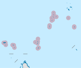 Location map of the Outer Islands of the Seychelles archipelago in the western Indian Ocean | |
| Geography | |
| Location | Indian Ocean |
| Coordinates | 5°58′S 53°03′E |
| Archipelago | Seychelles |
| Adjacent bodies of water | Indian Ocean |
| Total islands | 200 |
| Major islands | |
| Area | 216.57 km2 (83.62 sq mi) |
| Highest elevation | 35 m (115 ft) |
| Highest point | unnamed dune |
| Administration | |
Seychelles | |
| Group | Outer Islands |
| Districts | Outer Islands District |
| Largest settlement | Coëtivy Island (pop. 260) |
| Demographics | |
| Population | 574 (estimate) (2019)[1] |
| Pop. density | 3.23/km2 (8.37/sq mi) |
| Ethnic groups | Creole, French, East Africans, Indians. |
| Additional information | |
| Time zone |
|
| ISO code | SC-26 |
| Official website | www |
History
Until 2008, the islands were outside the administrative and electoral Districts of Seychelles. In 2008 the shrimp farm closed on Coëtivy Island which caused a wave of job-seekers coming to Mahé. The ministry of tourism was granted a free hand on these islands in order to settle down the unrest of the population, and declared it a district.
It formed the Islands Development Company (IDC) to control the islands, and prepared a program called 1 hotel 1 island. Each island in the group should be leased to a hotel, which will in turn built several residential homes and facilities on those islands. It required removal of the Protected Area Status from the islands. At first finding hotel chains was difficult, so Coëtivy received a prison, and thus creating jobs for the people who came back to their island. Other islands received questionable facilities as well, e.g. Marie Louise Island a jail, Assumption Island an Army base, but on other islands had developments of resorts. The population increased again, for the first time in a century, from 500 in 2008 to 700 in 2016. Conservation in the outer islands is managed by Island Conservation Society.[2] The Save Our Seas Foundation manages the nature preserve of D'Arros Island and its neighboring atolls.[3]
Geography
The coral islands are flat with elevated coral reefs at different stages of formation. They are generally low-lying, and often form atolls around a central lagoon. The soils of the Corraline Seychelles are generally sandy and infertile, and hold little fresh water. The Inner Islands or Granitic Seychelles, by contrast, are composed of granite on the Seychelles Bank plateau, and are ancient fragments of continental crust. They are generally more mountainous, humid, and populated. The Outer Islands comprise 216.57 square kilometres (83.62 sq mi) or 46% of the total land area of the Seychelles, but hold less than 1% of the population of the country. The coral Outer Islands are located at distances of 230–1,150 kilometres (140–710 mi) from Mahé, the nation's principle island, located in the granitic Inner Seychelles.
Five groups
The Outer Islands are divided into five groups:
- Southern Coral Group — Île Platte and Coëtivy Island; land area 9.906 square kilometres (3.825 sq mi)
- Amirante Islands — 3 atolls (including Desroches Island – Île Desroches, 5 single sand cays including D'Arros Island), and 3 uplifted sand cays; land area 11.582 square kilometres (4.472 sq mi)
- Alphonse Group — Alphonse Atoll and St. François Atoll (Bijoutier-St. François); land area 2.21 square kilometres (0.85 sq mi)
- Aldabra Group — Aldabra Atoll, Assumption Island, Cosmoledo Atoll, and Astove Island; land area 180 square kilometres (69 sq mi)
- Farquhar Group — Farquhar Atoll, Providence Atoll (Providence-Cerf), and St. Pierre Island; land area 12.84 square kilometres (4.96 sq mi)
Demography
The lack of natural fresh water sources and infertile soils of these islands can sustain human life only with difficulty. As of 2016[update] the population is 701 although this figure increases during the short summer vacation when Mahe people come to work in tourism and fishing on the islands. There are 12 inhabited islands (2016), The major are Coëtivy with 260 and Desroches with a 100.[citation needed]
Image gallery
 Map 1
Map 1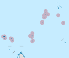 District Map
 Coralline Seychelles—Outer Islands, to south and west of Mahé and other Inner Islands.


Reference anonymous
- "POPULATION AND VITAL STATISTICS MID YEAR POPULATION ESTIMATES 2019". Statistical Bulletin. Victoria, Mahe, Seychelles: National Bureau of Statistics Seychelles. 2019-08-30. p. 17 (Table 10). Retrieved 2020-01-08.
- Island Conservation Seychelles. accessed 8.2.2012.
- Save Our Seas Foundation: "The D’Arros Group of Island becomes a natural reserve managed by Save our Seas Foundation" . accessed 8.2.2012.
External links
| Wikivoyage has a travel guide for Outer Seychelles. |
| Wikimedia Commons has media related to Outer Islands (Seychelles). |
- Island guide 1
- Island guide 2
- National Bureau of Statistics
- Info on the island
- 2010 Sailing directions
- Island Conservation Society website
Outer islands of Seychelles / Coralline Seychelles (Zil Elwannyen Sesel) | |||||||||||
|---|---|---|---|---|---|---|---|---|---|---|---|
| Outer island Groups |
|  | |||||||||
| Islands and Atolls |
| ||||||||||
Districts of Seychelles | ||
|---|---|---|
| Greater Victoria/ Central Mahé |
| |
| North Mahé |
| |
| East Mahé |
| |
| South Mahé |
| |
| West Mahé |
| |
| Inner Islands |
| |
| Outer Islands | ||
На других языках
[de] Outer Islands (Seychellen)
Als Outer Islands (Zil Elwannyen Sesel, deutsch „Äußere Inseln“) bezeichnet man die außerhalb der Seychellen-Bank gelegenen Atolle, gehobenen Atolle und Inseln der Republik Seychellen. Diese sind alle korallinen Ursprungs. Im Gegensatz dazu sind die auf der Seychellen-Bank gelegenen "Inner Islands" aus Granit (mit Ausnahme von Denis Island und Bird Island, die am nördlichen Rand der Seychellen-Bank liegen). Die Outer Islands liegen bis zu 1150 km von der Hauptinsel Mahé entfernt und sind über eine Meeresfläche von etwa 300.000 km² verstreut.- [en] Outer Islands (Seychelles)
[fr] Îles Extérieures
Les îles Extérieures, en créole seychellois Zil Elwannyen Sesel ou Zil Eloigne Sessel, forment un archipel des Seychelles composé des îles qui, par opposition aux îles Intérieures, ne se trouvent pas sur le plateau des Seychelles comme celle de Mahé et des îles proches. À cet archipel sont parfois rattachées les îles Glorieuses appartenant à la France et les îles Agaléga appartenant à Maurice.[it] Isole Esterne
Le Isole Esterne (Zil Elwannyen Sesel) formano una regione delle Seychelles, di 574 abitanti.[ru] Внешние Сейшельские острова
Внешние Сейшельские острова (сейш. Zil Elwannyen Sesel) — условное название нескольких групп островов в составе Республики Сейшельские Острова, за исключением собственно (внутренних) Сейшельских островов. Расположены в западной части Индийского океана. Не образуют единого географического целого. Находятся на расстоянии от 230 до 1150 км от главного сейшельского острова Маэ.Другой контент может иметь иную лицензию. Перед использованием материалов сайта WikiSort.org внимательно изучите правила лицензирования конкретных элементов наполнения сайта.
WikiSort.org - проект по пересортировке и дополнению контента Википедии