geo.wikisort.org - Island
Saint Joseph Atoll is part of the Amirante Islands group, which are in the Outer Islands (Coralline Seychelles) coral archipelago of the Seychelles islands and nation. The atoll is located southwest of the granitic Inner Seychelles archipelago, with a distance of 248 km south of Victoria, Seychelles.
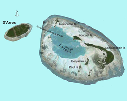 Map of D'Arros Island and neighboring St. Joseph Atoll, part of the Amirante Islands group | |
 St. Joseph Atoll | |
| Geography | |
|---|---|
| Location | Indian Ocean |
| Coordinates | 05°24′S 53°18′E |
| Type | Atoll |
| Archipelago | Seychelles |
| Adjacent bodies of water | Indian Ocean |
| Total islands | 13 |
| Major islands |
|
| Area | 1.632 km2 (0.630 sq mi) |
| Highest elevation | 3 m (10 ft) |
| Administration | |
Seychelles | |
| Group | Outer Islands |
| Sub-Group | Amirante Islands |
| Sub-Group | D'Arros and St. Joseph Atoll Special Reserve[1] |
| Districts | Outer Islands District |
| Largest settlement | St. Joseph (pop. 0) |
| Demographics | |
| Population | 0 (2014) |
| Pop. density | 0/km2 (0/sq mi) |
| Ethnic groups | Creole, French, East Africans, Indians. |
| Additional information | |
| Time zone |
|
| ISO code | SC-26 |
| Official website | www |
History
The atoll was discovered in 1770 by European sailors.[2]
- Private atoll
In 1960, The island became the property of a Seychellois family, who built a coconut plantation on the bigger St. Joseph island.
- Nature preserve
In August 2012 it was revealed that the atoll was sold, together with D'Arros Island, for US$60 million, to be managed by the Save Our Seas Foundation.[3][4]
Geography
Saint Joseph Atoll is located only 2.3 kilometres (1.4 mi) east of the eastern part of D'Arros Island, but it is a separate geographical unit, separated by 60–62 metres (197–203 ft) deep water of a 1 kilometre (0.62 mi) wide channel, which is deeper than much of the Amirantes Bank. The land area of the Atoll occupies 1.21 square kilometres (0.47 sq mi). The main Saint Joseph island is of crescent shaped, flat coral sand cay, 2.2 kilometres (1.4 mi) long and with average 0.4 kilometres (0.25 mi) wide, and nowhere higher than 3 metres (9.8 ft). The tree tops are about 24 m high.
Coral reefs
The Atoll stands on a detached patch coral reef similarly orientated, with maximum dimensions of 6.6 kilometres (4.1 mi) and 4.4 kilometres (2.7 mi). Its total area is 22.53 km2, of which 11.74 km2 comprises the peripheral reef flat, 4.8 km2 the interior lagoon, and only 1.39 km2 the land area of all islets. Depths of 500 m are found only 1.5 km east of the reef edge, and of 1000 m one kilometer further east.
Lagoon
The lagoon is completely enclosed by the surrounding reef. At low water it drains over a narrow sill, Passe Lerein Fin, at its western end. The lagoon has a maximum depth of 6.4 m. Other soundings range from 2.1 to 3.7 m. The peripheral reefs, in addition to being exceptionally wide, are covered (except on the west side) with mobile sand. Inter-tidal sand sheets are encroaching on the margins of the lagoon on its windward side, which is marked for much of its extent by a discontinuous linear sandbar. There are no growing reefs in the lagoon.
List of islets
The atoll has 13 sandy islets: the three larger ones along the northeast and east shore, which are covered by coconut plantations, and the remaining ones in the south:
| Island | type | Area (hectares) | Location | |
|---|---|---|---|---|
| 1 | Vars | sand cay | 0.21 | 05°24′22″S 53°19′34″E |
| 2 | Ressource | island | 12.10 | 05°24′34″S 53°19′36″E |
| 3 | Fouquet Island (ÎIe aux Fouquets) | island | 16.70 | 05°25′23″S 53°20′24″E |
| 4 | Pelican Cay (Pélicans) | sand cay | 6.00 | 05°26′10″S 53°20′56″E |
| 5 | Saint Joseph Island | island | 108.40 | 05°26′28″S 53°21′35″E |
| 6 | Carcassaye Island | sand cay | 2.72 | 05°24′22″S 53°21′23″E |
| 7 | Sable Islet | sand cay | 0.12 | 05°26′52″S 53°21′28″E |
| 8 | Benjamen Island | sand cay | 6.80 | 05°26′28″S 53°20′47″E |
| 9 | Ferrari Island | sand cay | 1.02 | 05°26′47″S 53°20′56″E |
| 10 | Chien Island | sand cay | 3.25 | 05°27′00″S 53°20′50″E |
| 11 | Paul Island (ÎIe aux Poules) | island | 4.58 | 05°26′44″S 53°20′28″E |
| 12 | Banc aux Cocos east | sand cay | 0.70 | 05°26′12″S 53°19′36″E |
| 13 | Banc aux Cocos west | sand cay | 0.60 | 05°26′04″S 53°19′21″E |
| St. Joseph Atoll | Atoll | 163.2 | 05°26′S 53°21′E |
Administration
The island belongs to Outer Islands District.[5]
Demographics
The atoll is currently uninhabited. it hosted a small population of 10, which now moved to D'Arros Island. There are several ruined buildings on the main island of St. Joseph, near the cultivated area at the western end.
Transport
You can reach the atoll with flights to unpaved airstrip (ICAO: FSDA).
Image gallery
 Map 1
Map 1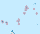 District Map


References
- https://www.facebook.com/todayinsey/posts/694669610570852 [user-generated source]
- Info on Mauritius and its dependencies
- "L'Oreal heiress Bettencourt sells Seychelles island". BBC News. August 1, 2012. They will manage it as a nature reserve.
- "The D'Arros Group of Island becomes a natural reserve managed by Save our Seas Foundation". Save Our Seas Foundation. August 1, 2012.
- District map
External links
Outer islands of Seychelles / Coralline Seychelles (Zil Elwannyen Sesel) | |||||||||||
|---|---|---|---|---|---|---|---|---|---|---|---|
| Outer island Groups |  | ||||||||||
| Islands and Atolls |
| ||||||||||
На других языках
[de] Saint-Joseph-Atoll
Das Saint-Joseph-Atoll ist ein unbewohntes Atoll im Indischen Ozean und gehört zur Inselgruppe der Amiranten und somit zu den Outer Islands der Seychellen.- [en] St. Joseph Atoll
[fr] Atoll Saint-Joseph
L'Atoll Saint-Joseph est un atoll faisant partie des Îles Amirante, un groupe d'îles des Seychelles dans l'Océan Indien.Другой контент может иметь иную лицензию. Перед использованием материалов сайта WikiSort.org внимательно изучите правила лицензирования конкретных элементов наполнения сайта.
WikiSort.org - проект по пересортировке и дополнению контента Википедии