geo.wikisort.org - Island
October Revolution Island (Russian: Остров Октябрьской Революции, Ostrov Oktyabrskoy Revolyutsii) is the largest island of the Severnaya Zemlya group in the Russian Arctic. It is named after the October Revolution which led to Russia becoming a Socialist country.
Native name: Остров Октябрьской Революции | |
|---|---|
 June 2001 satellite image of October Revolution Island showing the numerous ice caps | |
 October Revolution | |
| Geography | |
| Location | Arctic |
| Coordinates | 79°30′N 97°00′E |
| Archipelago | Severnaya Zemlya |
| Area | 14,170 km2 (5,470 sq mi)[1] |
| Area rank | 59th |
| Highest elevation | 963 m (3159 ft) |
| Highest point | Mount Karpinsky |
| Administration | |
Russia | |
| Krai | Krasnoyarsk Krai |
| Demographics | |
| Population | 0 |
The area of this island has been estimated at 14,170 km2 (5,470 sq mi) making it the 59th largest island in the world.[1] It rises to a height of 965 m (3,166 ft) on Mount Karpinsky. Half the island is covered with glaciers reaching down into the sea. In the sections free from ice, the vegetation is desert or tundra.
Geography
October Revolution Island houses five domed ice caps; clockwise from north, they are named: Rusanov, Karpinsky, University, Vavilov and Albanov.[2] The Rusanov and Karpinsky ice caps, located on the eastern side of the island, feed with glaciers the Matusevich Fjord of the Laptev Sea and the Marat Fjord of the Shokalsky Strait.[3] The Karpinsky ice cap reaches a maximum height of 963 m and it is also the highest point in Severnaya Zemlya.[4]
In 2015 the Vavilov Glacier accelerated dramatically due to warming. Between 2015 and 2016 the glacier front advanced 4 km and the glacier lost 4.5 km3 of ice.[5]
Other minor ice caps on the island include the Malyutka Glacier. The Podemnaya River and the Bolshaya River drain to the northwest between the Vavilov and Albanov glaciers, and the Bedovaya and Obryvistaya Rivers drain to the north between the Albanov and Rusanov ice caps.[6]
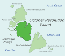
The coast of the island is uneven with rugged coves and headlands. The largest bays of the island are along the northern coast. The Red Army Strait separates October Revolution Island from Komsomolets Island to the north and from Pioneer Island in the northwest, while the broader Shokalsky Strait separates it from Bolshevik Island to the south. Both straits connect the Kara Sea in the west with the Laptev Sea in the east.[7] Cape October is located in the northern part of the island facing the Red Army Strait.[8]
History
The island was discovered by Boris Vilkitsky in 1913 during an expedition on behalf of the Russian Hydrographic Service, but its insularity was not proven until 1931, when Georgy Ushakov and Nikolay Urvantsev charted the archipelago during their 1930–1932 expedition.[9][10]
The Vavilov Meteorological Station was operated from 1974 to 1988 on the northern part of the Vavilov Ice Cap.[11]
 |
See also
- Arctic Ocean Hydrographic Expedition
- List of islands of Russia
- List of glaciers of Russia
References
- McCoy, John F. (ed.) (2002) Geo-Data: The World Geographical Encyclopedia Thomson-Gale
- ""Severnaya Zemlya" OceanDots.com". Archived from the original on 23 December 2010. Retrieved 23 December 2010.
{{cite web}}: CS1 maint: bot: original URL status unknown (link) - Mark Nuttall, Encyclopedia of the Arctic, p. 1887
- Обзорно-географический Атлас России. — Картография, АСТ, Астрель, 2010. — С. 147.
- Katie Weeman (19 September 2018). "Unprecedented ice loss in Russian ice cap".
- Männik, Peep et al. (2002) "Silurian and Devonian strata Severnaya Zemlya and Sedov archipelagos (Russia)" Geodiversitas 24(1): pp. 99–122;
- "Proliv Shokal'skogo". Mapcarta. Retrieved 23 November 2016.
- "Mys Oktyabr'skiy". Mapcarta. Retrieved 28 December 2016.
- Barr, William (1975). "Severnaya Zemlya: the last major discovery". Geographical Journal. 141 (1): 59–71. doi:10.2307/1796946.
- "Октябрьской Революции Остров"[permanent dead link] Great Soviet Encyclopedia
- Bassford, R.P. et al. (2006) "Quantifying the Mass Balance of Ice Caps on Severnaya Zemlya, Russian High Arctic. I: Climate and Mass Balance of the Vavilov Ice Cap" Arctic, Antarctic, and Alpine Research 38(1): pp. 1–12 link to abstract only
External links
 Media related to October Revolution Island at Wikimedia Commons
Authority control | |
|---|---|
| General |
|
| National libraries | |
На других языках
[de] Oktoberrevolutions-Insel
Die Oktoberrevolutions-Insel (russisch Остров Октябрьской Революции, Ostrow Oktjabrskoi Rewoljuzii) liegt im Arktischen Ozean nördlich des russischen Festlands. Sie ist mit etwa 14.170 km² die größte der Sewernaja-Semlja-Inseln.- [en] October Revolution Island
[es] Isla Revolución de Octubre
La isla Revolución de Octubre (en ruso: Остров Октябрьской Революции, Ostrov Oktyabrskoy Revolyutsii) es la mayor isla del archipiélago de la Tierra del Norte, y está localizada en el Ártico de Rusia. Con una superficie estimada de 14 170 km², es la 59.ª isla más grande del mundo.[1][it] Isola della Rivoluzione d'Ottobre
L'isola della Rivoluzione d'Ottobre[1][2] (in russo: Остров Октябрьской Революции?, Ostrov Oktjabr'skoj Revoljucii) è l'isola centrale e la maggiore dell'arcipelago della Severnaja Zemlja, nel mare Glaciale Artico. Amministrativamente, fa parte del Kraj di Krasnojarsk, in Russia.[ru] Остров Октябрьской Революции
О́стров Октя́брьской Револю́ции — центральный остров архипелага Северная Земля (Россия). Административно относится к Таймырскому Долгано-Ненецкому району Красноярского края.Другой контент может иметь иную лицензию. Перед использованием материалов сайта WikiSort.org внимательно изучите правила лицензирования конкретных элементов наполнения сайта.
WikiSort.org - проект по пересортировке и дополнению контента Википедии