geo.wikisort.org - Island
Mulroy Island is a small island which lies just off Black Crag, the northeast extremity of Noville Peninsula, Thurston Island. Discovered by the U.S. Navy Bellingshausen Sea Expedition in February 1960. Named by Advisory Committee on Antarctic Names (US-ACAN) for Thomas B. Mulroy, fuel engineer with Byrd Antarctic Expedition in 1928–30.
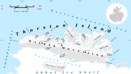 Map of Thurston Island | |
 Mulroy Island Location in Antarctica | |
| Geography | |
|---|---|
| Location | Antarctica |
| Coordinates | 71°51′S 98°0′W |
| Administration | |
| Administered under the Antarctic Treaty System | |
| Demographics | |
| Population | Uninhabited |

Maps
- Thurston Island – Jones Mountains. 1:500000 Antarctica Sketch Map. US Geological Survey, 1967.
- Antarctic Digital Database (ADD). Scale 1:250000 topographic map of Antarctica. Scientific Committee on Antarctic Research (SCAR). Since 1993, regularly upgraded and updated.
See also
- List of Antarctic and sub-Antarctic islands
![]() This article incorporates public domain material from the United States Geological Survey document: "Mulroy Island". (content from the Geographic Names Information System)
This article incorporates public domain material from the United States Geological Survey document: "Mulroy Island". (content from the Geographic Names Information System)
Antarctica | ||||||||
|---|---|---|---|---|---|---|---|---|
| Geography |
|  | ||||||
| History |
| |||||||
| Politics |
| |||||||
| Society |
| |||||||
| Famous explorers |
| |||||||
| ||||||||
This Thurston Island location article is a stub. You can help Wikipedia by expanding it. |
На других языках
[de] Mulroy Island
Mulroy Island ist eine kleine Insel vor der Nordküste der westantarktischen Thurston-Insel. Sie liegt vor dem am östlichen Ausläufer der Noville-Halbinsel liegenden Black Crag.- [en] Mulroy Island
Текст в блоке "Читать" взят с сайта "Википедия" и доступен по лицензии Creative Commons Attribution-ShareAlike; в отдельных случаях могут действовать дополнительные условия.
Другой контент может иметь иную лицензию. Перед использованием материалов сайта WikiSort.org внимательно изучите правила лицензирования конкретных элементов наполнения сайта.
Другой контент может иметь иную лицензию. Перед использованием материалов сайта WikiSort.org внимательно изучите правила лицензирования конкретных элементов наполнения сайта.
2019-2026
WikiSort.org - проект по пересортировке и дополнению контента Википедии
WikiSort.org - проект по пересортировке и дополнению контента Википедии