geo.wikisort.org - Island
Mathraki (Greek: Μαθράκι, Ancient Greek: Μαθράκιον) is an island and a former community of the Ionian Islands, Greece. It is one of the Diapontian Islands. Since the 2019 local government reform it is part of the municipality of Central Corfu and Diapontian Islands, of which it is a municipal unit.[2] The municipal unit has an area of 3.532 km2.[3] Population 329 (2011). Mathraki is a 45-minute boat ride off the coast of Corfu (4 NM from Cape Arilas). It has three restaurants that double as general stores, villas and "rooms to let". Mathraki is a quiet island that manages to stay clear of tourists except for the occasional hikers that brave the rocky coastline. The municipal unit includes the three nearby islets Diakopo, Diaplo and Tracheia.
Mathraki | |
|---|---|
 Mathraki Location within the regional unit 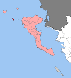 | |
| Coordinates: 39°46′N 19°31′E | |
| Country | Greece |
| Administrative region | Ionian Islands |
| Regional unit | Corfu |
| Municipality | Central Corfu and Diapontian Islands |
| • Municipal unit | 3.532 km2 (1.364 sq mi) |
| Highest elevation | 152 m (499 ft) |
| Population (2011)[1] | |
| • Municipal unit | 329 |
| • Municipal unit density | 93/km2 (240/sq mi) |
| Time zone | UTC+2 (EET) |
| • Summer (DST) | UTC+3 (EEST) |
| Postal code | 491 00 |
| Area code(s) | 26630 |
| Vehicle registration | ΚΥ |
| Website | mathraki.net |
History
Mathraki was inhabited since the 16th century by settlers from the nearby islands of Paxoi and Othonoi. The origin of its name is unknown, but according to a popular tradition, derives from anthrakia, because in the past the island had been burnt.[4] It became part of Greece in 1864, when the Ionian islands were ceded to Greece by the British. Today it is a serene and tranquil place for holidays. In 2021 the only elementary school of the island re-opened after 21 years with only one student.[5]
Historical population
| Year | Population |
|---|---|
| 2001 | 297 |
| 2011 | 329 |
References
- "Απογραφή Πληθυσμού - Κατοικιών 2011. ΜΟΝΙΜΟΣ Πληθυσμός" (in Greek). Hellenic Statistical Authority.
- "Τροποποίηση του άρθρου 1 του ν. 3852/2010" [Amendment of Article 1 of l. 3852/2010] (in Greek). Government Gazette. p. 1164.
- "Population & housing census 2001 (incl. area and average elevation)" (PDF) (in Greek). National Statistical Service of Greece. Archived from the original (PDF) on 2015-09-21.
- "Στο λιμάνι της γαλήνης". kathimerini.gr. Retrieved 21 June 2015.
- IEFIMERIDA.GR, NEWSROOM (2021-09-15). "Ανοιξε μετά από 21 χρόνια το σχολείο στο νησί Μαθράκι, με έναν μαθητή, τον Τάσο -Συγκίνηση στον αγιασμό [βίντεο] | ΕΛΛΑΔΑ". iefimerida.gr (in Greek). Retrieved 2021-09-15.
External links
- Official site from Local Authority Official site from Mathraki Local Authority (Languages Greek-English-Italian
- Official site from Prefecture of Corfu Official site from Prefecture of Corfu (multi language)
- Website for Mathraki Island www.mathraki.net
This Ionian Islands location article is a stub. You can help Wikipedia by expanding it. |
На других языках
[de] Mathraki
Mathraki (griechisch Μαθράκι (n. sg.), Aussprache: [.mw-parser-output .IPA a{text-decoration:none}maˈθrakʲi]) ist eine kleine griechische Insel im Ionischen Meer, die zur Inselgruppe der Diapontischen Inseln gehört und damit Teil der Ionischen Inseln ist. Die nur etwa drei Quadratkilometer große Insel (4 km lang, bis zu 1,5 km breit) ist rund zehn Kilometer von der Nordwestküste Korfus entfernt. Höchste Erhebung ist mit 150 Metern der Vouno oder Samothraki.- [en] Mathraki
[es] Mazraki
Mazraki (en griego Μαθράκι) es una pequeña isla jónica del archipiélago de Diapontia, situada a unos 10 km al norte de Corfú, prácticamente equidistante de Othonoí y Erikusa. Administrativamente pertenece a la periferia de Islas Jónicas y la unidad periférica de Corfú.[1] La única población de la isla se denomina también Mazraki.[2][fr] Mathraki
Mathraki (en grec moderne : Μαθράκι, ancienne forme : Μαθράκιον) est une île grecque appartenant à l'archipel des îles Ioniennes.[ru] Матракион
Матра́кион[1] (греч. Μαθράκιον[2]) или Матра́ки[3] (греч. Μαθράκι) — остров в Греции. Входит в острова Диапонтии-Ниси в составе Ионических островов. Расположен в 9 километрах к западу от Керкиры, к югу от Эрикусы и от Отони. Остров вытянут с севера на юг. На северо-востоке острова расположен песчаный пляж и порт. Входит в общину (дим) Центральная Керкира и Диапонтии-Ниси в периферийной единице Керкира в периферии Ионические острова. Площадь острова составляет 3,092 квадратного километра[4]. Население 329 жителей по переписи 2011 года[2].Другой контент может иметь иную лицензию. Перед использованием материалов сайта WikiSort.org внимательно изучите правила лицензирования конкретных элементов наполнения сайта.
WikiSort.org - проект по пересортировке и дополнению контента Википедии