geo.wikisort.org - Island
Ereikoussa (Greek: Ερεικούσσα, Italian: Merlera) is an island and a former community of the Ionian Islands, Greece. It is one of the Diapontian Islands; an island complex to the northwest of Corfu. Since the 2019 local government reform it is part of the municipality of Central Corfu and Diapontian Islands, of which it is a municipal unit.[2] It is located off the northwestern coast of the island of Corfu, and is almost equidistant from Corfu to the southeast, Mathraki to the southwest, and Othonoi to the west. Its population was 496 in the 2011 census, and its land area is 3.65 square kilometres (1 sq mi). The municipal unit has an area of 4.449 km2.[3] It has six settlements; the main one is Porto (Πόρτο), which is also where the only port is located.[4][5] The island has dense vegetation and three beaches; Porto (Πόρτο), Bragini (Μπραγκίνι), and Fiki (Φύκι).[5][6] The name Ereikoussa derives from the plant ereíki (ερείκη), which can be found throughout the island.[4][5][6]
Ereikoussa
Ερεικούσσα | |
|---|---|
 | |
 Ereikoussa Location within the regional unit 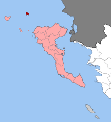 | |
| Coordinates: 39°53′N 19°35′E | |
| Country | Greece |
| Administrative region | Ionian Islands |
| Regional unit | Corfu |
| Municipality | Central Corfu and Diapontian Islands |
| • Municipal unit | 4.449 km2 (1.718 sq mi) |
| Population (2011)[1] | |
| • Municipal unit | 496 |
| • Municipal unit density | 110/km2 (290/sq mi) |
| Time zone | UTC+2 (EET) |
| • Summer (DST) | UTC+3 (EEST) |
| Website | www |
References
- "Απογραφή Πληθυσμού - Κατοικιών 2011. ΜΟΝΙΜΟΣ Πληθυσμός" (in Greek). Hellenic Statistical Authority.
- "Τροποποίηση του άρθρου 1 του ν. 3852/2010" [Amendment of Article 1 of l. 3852/2010] (in Greek). Government Gazette. p. 1164.
- "Population & housing census 2001 (incl. area and average elevation)" (PDF) (in Greek). National Statistical Service of Greece. Archived from the original (PDF) on 2015-09-21.
- "Διαπόντια Νησιά: Το «άγνωστο» δυτικότερο άκρο της Ελλάδας (φωτο)". Pronews.gr (in Greek). 11 June 2019. Retrieved 24 June 2022.
- "10 εναλλακτικά και άγνωστα παραδεισένια νησιά της Ελλάδας". Lifo (in Greek). 19 August 2019. Retrieved 24 June 2022.
- "Μια σταλιά νησάκι, σαν από άλλη εποχή: Η «γαλάζια λίμνη» του Ιονίου που ανταγωνίζεται στα ίσα Κέρκυρα και Κεφαλονιά". Ethnos (in Greek). 24 May 2022. Retrieved 24 June 2022.
This Ionian Islands location article is a stub. You can help Wikipedia by expanding it. |
На других языках
[de] Errikousa
Errikousa (griechisch Ερρείκουσα [.mw-parser-output .IPA a{text-decoration:none}ɛˈrikusa] (f. sg.) ältere Schreibweise auch Erikoussa (Ερεικούσσα)) ist die nördlichste der Othonischen oder Diapontischen Inseln. Die Insel gehört zu Griechenland und liegt etwa 11 km von der Küste Korfus entfernt. Mit einer Ausdehnung von etwa 2 × 2 km und einer Fläche von 4 km² ist sie die zweitgrößte der Diapontischen oder Othonischen Inseln, auf der die wenigen Einwohner hauptsächlich von der Landwirtschaft, insbesondere dem Olivenanbau, sowie dem bescheidenen Fischfang und dem Tourismus leben. Höchste Erhebung ist mit 130 m der Merlera.- [en] Ereikoussa
[fr] Érikoussa
Érikoussa (grec moderne : Ερείκουσα, italien : Merlera) est une île grecque appartenant à l'archipel des îles Ioniennes. Á l'entrée en vigueur de la réforme des collectivités locales en 2011, l'île devient un district municipal du dème (municipalité) de Corfou[1]. Depuis 2019, l'île est rattachée au dème de Corfou-Centre et des îles Diapontiques à la suite de la suppression du dème unique de Corfou dans le cadre du programme Clisthène I[2].[ru] Эрикуса
Эри́куса[1] (греч. Ερεικούσσα[2] ή Ερείκουσα) — остров в Греции. Входит в острова Диапонтии-Ниси в составе Ионических островов. Площадь острова 4,381 квадратного километра[3]. Административно входит в общину (дим) Центральная Керкира и Диапонтии-Ниси в периферийной единице Керкира в периферии Ионические острова. Население 496 жителей по переписи 2011 года[2]. Площадь сообщества 4,449 квадратного километра[4].Другой контент может иметь иную лицензию. Перед использованием материалов сайта WikiSort.org внимательно изучите правила лицензирования конкретных элементов наполнения сайта.
WikiSort.org - проект по пересортировке и дополнению контента Википедии