geo.wikisort.org - Isla
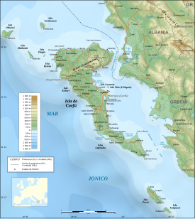
Mazraki (en griego Μαθράκι) es una pequeña isla jónica del archipiélago de Diapontia, situada a unos 10 km al norte de Corfú, prácticamente equidistante de Othonoí y Erikusa. Administrativamente pertenece a la periferia de Islas Jónicas y la unidad periférica de Corfú.[1] La única población de la isla se denomina también Mazraki.[2]
| Mazraki | ||
|---|---|---|
| Μαθράκι | ||
 | ||
| Ubicación geográfica | ||
| Región | Diapontia | |
| Archipiélago | Islas Jónicas | |
| Mar | Mar Jónico | |
| Coordenadas | 39°46′00″N 19°31′00″E | |
| Ubicación administrativa | ||
| País |
| |
| División | Corfú | |
| Subdivisión | Corfú | |
| Periferia | Islas Jónicas | |
| Características generales | ||
| Superficie | 3,52 | |
| Longitud | 3,5 km | |
| Anchura máxima | 1 km | |
| Punto más alto | 152 m | |
| Población | ||
| Población | 329 hab. (2011) | |
| Densidad | 84 hab./km² | |
| Mapa de localización | ||
|
Mazraki en la unidad periférica de Corfú | ||
 Mapa topográfico de Corfú y Paxoí Mapa topográfico de Corfú y Paxoí | ||
Toponimia
Según una leyenda, la isla fue destruida por fuego de carbones (en griego ανθράκια, anthrákia) y de ahí deriva su nombre. En realidad, su nombre antiguo era «Malthaki» (Μαλθάκι), habiéndose transformado por influencia de Samotracia (Σαμοθράκη).[2]
Geografía física
Mazraki es una isla frondosa, cubierta por olivos y pinos. En sus cercanías se encuentran tres islotes: Diakopo, Diaplo y Tracheia.[2]
Véase también
- Diapontia
- Islas Jónicas
Referencias
- «Texto completo del plan Calícrates». Boletín Oficial de Grecia (en griego). 11 de agosto de 2010. Archivado desde el original el 12 de junio de 2018. Consultado el 19 de julio de 2011.
- Voyatzis, G.; Petris, T.; Desipris, G. (2007). «Mazraki». Corfú y Paxós. Koropi (Ática): Toubi's. p. 158. ISBN 978-960-540-742-1.
На других языках
[de] Mathraki
Mathraki (griechisch Μαθράκι (n. sg.), Aussprache: [.mw-parser-output .IPA a{text-decoration:none}maˈθrakʲi]) ist eine kleine griechische Insel im Ionischen Meer, die zur Inselgruppe der Diapontischen Inseln gehört und damit Teil der Ionischen Inseln ist. Die nur etwa drei Quadratkilometer große Insel (4 km lang, bis zu 1,5 km breit) ist rund zehn Kilometer von der Nordwestküste Korfus entfernt. Höchste Erhebung ist mit 150 Metern der Vouno oder Samothraki.[en] Mathraki
Mathraki (Greek: Μαθράκι, Ancient Greek: Μαθράκιον) is an island and a former community of the Ionian Islands, Greece. It is one of the Diapontia Islands. Since the 2019 local government reform it is part of the municipality of Central Corfu and Diapontia Islands, of which it is a municipal unit.[2] The municipal unit has an area of 3.532 km2.[3] Population 329 (2011). Mathraki is a 45-minute boat ride off the coast of Corfu (4 NM from Cape Arilas). It has three restaurants that double as general stores, villas and "rooms to let". Mathraki is a quiet island that manages to stay clear of tourists except for the occasional hikers that brave the rocky coastline. The municipal unit includes the three nearby islets Diakopo, Diaplo and Tracheia.- [es] Mazraki
[fr] Mathraki
Mathraki (en grec moderne : Μαθράκι, ancienne forme : Μαθράκιον) est une île grecque appartenant à l'archipel des îles Ioniennes.[ru] Матракион
Матра́кион[1] (греч. Μαθράκιον[2]) или Матра́ки[3] (греч. Μαθράκι) — остров в Греции. Входит в острова Диапонтии-Ниси в составе Ионических островов. Расположен в 9 километрах к западу от Керкиры, к югу от Эрикусы и от Отони. Остров вытянут с севера на юг. На северо-востоке острова расположен песчаный пляж и порт. Входит в общину (дим) Центральная Керкира и Диапонтии-Ниси в периферийной единице Керкира в периферии Ионические острова. Площадь острова составляет 3,092 квадратного километра[4]. Население 329 жителей по переписи 2011 года[2].Текст в блоке "Читать" взят с сайта "Википедия" и доступен по лицензии Creative Commons Attribution-ShareAlike; в отдельных случаях могут действовать дополнительные условия.
Другой контент может иметь иную лицензию. Перед использованием материалов сайта WikiSort.org внимательно изучите правила лицензирования конкретных элементов наполнения сайта.
Другой контент может иметь иную лицензию. Перед использованием материалов сайта WikiSort.org внимательно изучите правила лицензирования конкретных элементов наполнения сайта.
2019-2026
WikiSort.org - проект по пересортировке и дополнению контента Википедии
WikiSort.org - проект по пересортировке и дополнению контента Википедии