geo.wikisort.org - Island
Long Island is an island in The Bahamas that is split by the Tropic of Cancer.[2] It is one of the Districts of the Bahamas and is known as the most scenic island in the Bahamas. Its capital is Clarence Town. The population of Long Island is 3,094 inhabitants.[3]
District of Long Island | |
|---|---|
 | |
| Coordinates: 23.176499°N 75.096212°W | |
| Country | |
| Island | Long Island |
| Established | 1996 |
| Government | |
| • Type | District Council |
| • Chief Councillor | Ian Knowles |
| • Deputy Chief Councillor | Dwayne Fox |
| Area | |
| • Total | 596 km2 (230 sq mi) |
| Population (2010) | |
| • Total | 3,094 |
| • Density | 5.2/km2 (13/sq mi) |
| Demographics 2010[1] | |
| • Black | 54.36% |
| • Black and White | 20.78% |
| • White | 18.07% |
| • Other | 5.95% |
| Time zone | UTC−5 (EST) |
| • Summer (DST) | UTC−4 (EDT) |
| Area code(s) | 242 |

Geography
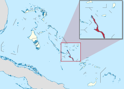
Long Island is about 130 kilometers (80 mi) long and 6 km (4 mi) wide at its widest point. The land area is 596 km2 (230 sq mi). Long Island is situated about 265 km (165 mi) southeast of the Bahamian capital of Nassau, which is located on the island of New Providence. The Tropic of Cancer runs through the northern quarter of the island.[2]
The northeast side of Long Island is noted for its steep rocky headlands, while the southwest coast is noted for its broad white beaches with soft sand. The terrain ranges widely throughout the island, including white flat expanses from which salt is extracted, swamplands, beaches, and sloping (in the north) and low (in the south) hills.
Long Island is particularly noted for its caves, which have played a major role in the island's history. Dean's Blue Hole, located west of Clarence Town, is the world's second deepest underwater sinkhole, dropping to a depth of about 200 meters, making it more than double the depth of most other large holes.
Long Island is surrounded by small bays and inlets, including the large New Found Harbour west of Deadman's Cay, at approximately the midsection of the island. There are also smaller islands off-shore, including Sandy Cay.
History
Some writers identify Long Island as the site of one of Christopher Columbus' landfalls during his 1492 voyage. For example, Joseph Judge and Samuel Eliot Morison identify Long Island as corresponding to the third island visited by Columbus, which he called Fernandina and which the indigenous Arawak people called Yuma. However, a variety of other historians, geographers, and other writers identify Fernandina as corresponding to different islands in the Bahamas, including Little Inagua, Great Exuma, and Andros Island.[4] Archaeological evidence, including ceremonial stools called duhos, shows that the Lucayan Taíno tribe settled on Long Island, probably in the island's cave system. After the demise of the Lucayans, who were taken as slaves to Hispaniola and Cuba, there was no large settlement until the arrival of the Simms family in 1720 who originally arrived in The Bahamas in the 1640s.
The original Loyalists were mainly from New England and New Jersey and arrived on Long Island after fleeing the American Revolution. These families started the first farms, primarily raising cattle and sheep. By the 1790s, settlers began to arrive from the Carolinas and proceeded to set up cotton plantations. The plantations flourished for only a few years and, by the time of the abolition of slavery in 1834, most had collapsed and been abandoned. There are many ruins from this era today, the majority of which are overgrown by bush. There are also remains of some of the houses built after slavery, which are usually small and built of stone. Originally, they had thatched roofs; today, most are shingled. The descendants of these families continue to be widespread on the island.
Settlements
Clarence Town, located in the south-central portion of the island, has a population 86 people.[3] Nearby Deadman's Cay (pop. 328) is the major settlement at the centre of the island and is home to Deadman's Cay Airport, which offers flights daily to Nassau and is the island's largest and busiest airport.
Mangrove Bush (pop. 142) is the home of the island's boat-building trade, while Hamilton's (pop. 196) is noted for its extensive cave system that is partially open for tours. Salt Pond (pop. 98) is home of the Long Island Regatta, an annual event that draws tourists from around the world. Stella Maris (pop. 80), at the northern part of the island, is the centre of the island's tourism industry and features several resorts. It is served by Stella Maris Airport. Seymour's, the northernmost settlement, has a monument dedicated to Christopher Columbus. Buckley's (pop. 54) is home to Nelson Glandville McFarlane Major High School, which frequently has the highest Bahamian GCSE scores among the nation's public schools, as well as the Long Island Library and Museum.
Other settlements include Roses (or Roses Settlement),[5] Scrub Hill, Simms, and Burnt Ground. Most of the island's settlements are named after the families that first settled them. As a result, many (but not all) are named in the possessive form. The settlement of the Gray family, for example, is known as Gray's.
One main road, originally designed for carriages, runs from Cape Santa Maria, at the northern tip of Long Island, to the southern tip at Gordon's. Transport on Long Island is road-based, with limited taxi service available, particularly from Stella Maris to Deadman's Cay and Clarence Town.
Economy and tourism
Part of the economy is based on tourism and farming, but fishing dominates. The inhabitants grow peas, corn, bananas, and they raise small livestock such as pigs, chickens, goats, and sheep. Some cattle are raised for export.
Due to the generally inhospitable soil of the Bahamas, much of the farming done on Long Island is in the pot-hole style, which involves planting in fertile holes in the limestone where good top soil collects. This method of farming contributes to the success of Long Island farmers, who are usually able to generate enough excess produce to sell their fruits and vegetables throughout the Bahamas.
Tourist opportunities include sailing, fishing, scuba diving, freediving, snorkelling and relaxing on beaches. Cape Santa Maria Beach, located at Seymour's, is frequently ranked as one of the most beautiful beaches in the world. In recent years, competitive freedivers have sought out Dean's Blue Hole as a unique dive site, hosting both world records (most notably by New Zealander William Trubridge) and one world championship (in 2009).[6] Most tourists charter an airplane or take a commercial flight from Exuma International Airport at George Town, Exuma or Nassau. International flights offered by Locair were planned which would have marked the return of regular international flights in over ten years; however, Locair is no longer in business.
Airports
The island has two airports, Deadman's Cay Airport which is served by Bahamasair and other local air carriers and Stella Maris Airport which also has local air carrier service.
Stella Maris airport was designed and built by Jack Henry Cordery who was engaged by Stella Maris Estate Company in 1967 when he emigrated from England to take the job of Estate Development Manager. He also developed the Marina and built roads. He died on Long Island in 1968 and is buried at Burnt Ground.
 Windward shore of Long Island, The Bahamas.
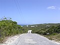 Road on Long Island, The Bahamas.
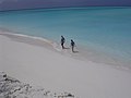 Lee shore beach on Long Island, The Bahamas.
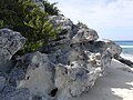 Holocene eolianite on Long Island, The Bahamas.
 Columbus Monument on Long Island, The Bahamas.
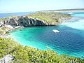 The Dean's Blue Hole.


See also
- Bahama Banks
- Geography of the Bahamas
- History of the Bahamas
- List of islands of the Bahamas
- Lucayan Archipelago
- Out Islands
- Voyages of Christopher Columbus
References
- "Department of Statistics of the Bahamas" (PDF). bahamas.gov.bs. Retrieved 30 March 2022.
- "Long Island, Island of the Bahamas". The Islands of the Bahamas. Retrieved 18 November 2013.
- LONG ISLAND POPULATION BY SETTLEMENT AND TOTAL NUMBER OF OCCUPIED DWELLINGS: 2010 CENSUS - Bahamas Department of Statistics
- Wilcomb E. Washburn, "Landfall Controversy" in The Christopher Columbus Encyclopedia, Vol. 1 (ed. Silvio A. Bedin: Simon & Schuster, 1992).
- "Roses, Bahamas, The Page". Falling Rain. Falling Rain Genomics, Inc. 27 February 2015. Archived from the original on 23 October 2015. Retrieved 22 January 2017.
- Skolnick, Adam. "A Deep-Water Diver From Brooklyn Dies After Trying for a Record". November 17, 2013. New York Times. Retrieved 18 November 2013.
External links
| Authority control |
|
|---|
На других языках
[de] Long Island (Bahamas)
Long Island ist eine Insel der Bahamas und hat eine Ausdehnung von 130 km Länge und bis zu sechs km Breite. Die Insel liegt 265 km südöstlich der Hauptstadt Bahamas Nassau. Zur Volkszählung 2010 hatte die Insel 3024 Einwohner (einschließlich der der Nordspitze vorgelagerten Insel Galliot Cay). Größter Ort war Burnt Ground mit 324 Einwohnern, gefolgt von Lower Deadman’s Cay mit 272 Einwohnern und Hamilton mit 196 Einwohnern. Im Hauptort Clarence Town lebten nur 86 Einwohner.[1]- [en] Long Island, Bahamas
[es] Isla Larga (Bahamas)
Isla Larga (en inglés: Long Island) es una isla de ochenta millas (casi 130 kilómetros) de largo en las Bahamas, que está dividida por el trópico de Cáncer. La isla posee solo cuatro millas (6 km) de ancho, pero se extiende por un trecho de mayor longitud. Isla Larga esta a aproximadamente 165 millas o 265 kilómetros al sureste de Nassau. Algunos de los principales asentamientos son Clarence City o Ciudad Clarence, que es la capital de la isla, Hamilton (famoso por su cueva de viajes), The Buckley, Scrub Hill, Simms, Salt Pond y Stella Maris. Isla Larga es uno de los distritos de las Bahamas reconocidos como uno de los más pintorescos de todo el archipiélago.[fr] Long Island (Bahamas)
Long Island est une île de l'archipel des Bahamas.[it] Long Island (Bahamas)
Long Island è un'isola e un distretto di Bahamas lunga circa 130 km e larga 6 km situata a circa 265 km a sud-est dalla capitale Nassau.Другой контент может иметь иную лицензию. Перед использованием материалов сайта WikiSort.org внимательно изучите правила лицензирования конкретных элементов наполнения сайта.
WikiSort.org - проект по пересортировке и дополнению контента Википедии