geo.wikisort.org - Island
Little Andaman Island (Onge: Gaubolambe) is the fourth largest of the Andaman Islands of India with an area of 707 km2, lying at the southern end of the archipelago. It belongs to the South Andaman administrative district, part of the Indian union territory of Andaman and Nicobar Islands.[6] It lies 88 km (55 mi) south of Port Blair, the capital of Andaman and Nicobar Islands.
Native name: Gaubolambe | |
|---|---|
 Little Andaman Island Location in the Andaman and Nicobar Islands and in the Bay of Bengal  Little Andaman Island Little Andaman Island (Bay of Bengal) | |
| Geography | |
| Location | Bay of Bengal |
| Coordinates | 10.65°N 92.49°E |
| Archipelago | Andaman Islands |
| Adjacent bodies of water | Indian Ocean |
| Area | 707 km2 (273 sq mi)[1] |
| Area rank | 1 |
| Length | 24 km (14.9 mi) |
| Width | 43 km (26.7 mi) |
| Coastline | 132 km (82 mi) |
| Highest elevation | 183 m (600 ft)[2] |
| Administration | |
| District | South Andaman |
| Island group | Andaman Islands |
| Island sub-group | Little Andaman Group |
| Tehsil | Little Andaman Tehsil |
| Largest settlement | Kwate-tu-Kwage (Hut Bay) |
| Demographics | |
| Population | 18,823 (2011) |
| Pop. density | 26.6/km2 (68.9/sq mi) |
| Ethnic groups | Onge, other Indians |
| Additional information | |
| Time zone |
|
| PIN | 744207[3] |
| Telephone code | 031927[4] |
| ISO code | IN-AN-00[5] |
| Official website | www |
| Literacy | 84.4% |
| Avg. summer temperature | 30.2 °C (86.4 °F) |
| Avg. winter temperature | 23.0 °C (73.4 °F) |
| Sex ratio | 1.2♂/♀ |
| Census Code | 35.640.0009 |
| Official Languages | Hindi, English |
Geography
The island is in the Bay of Bengal and belongs to the Little Andaman Group, and is separated from Rutland Island in Great Andaman by the Duncan Passage. The Little Andaman Group is the counterpart of the Great Andaman island group.
The low-lying island has widespread rainforest and several rare species of marine turtle. Little Andaman Island has white sandy beaches and bewitching waterfalls. The Little Andaman Lighthouse (a.k.a. Richardson's Lighthouse) is located 14 km south by road from Hut Bay port and is situated on the Southern tip of Little Andaman Island.[7]
Climate
| Climate data for Little Andaman (Hut Bay) 1981–2010, extremes 1969–2012 | |||||||||||||
|---|---|---|---|---|---|---|---|---|---|---|---|---|---|
| Month | Jan | Feb | Mar | Apr | May | Jun | Jul | Aug | Sep | Oct | Nov | Dec | Year |
| Record high °C (°F) | 34.4 (93.9) |
35.2 (95.4) |
36.4 (97.5) |
36.4 (97.5) |
35.8 (96.4) |
36.3 (97.3) |
36.4 (97.5) |
35.6 (96.1) |
33.6 (92.5) |
34.8 (94.6) |
34.0 (93.2) |
34.4 (93.9) |
36.4 (97.5) |
| Average high °C (°F) | 30.9 (87.6) |
31.5 (88.7) |
32.5 (90.5) |
33.2 (91.8) |
31.9 (89.4) |
30.9 (87.6) |
30.6 (87.1) |
30.3 (86.5) |
30.2 (86.4) |
30.7 (87.3) |
30.9 (87.6) |
30.7 (87.3) |
31.2 (88.2) |
| Average low °C (°F) | 22.6 (72.7) |
21.3 (70.3) |
21.8 (71.2) |
23.0 (73.4) |
24.1 (75.4) |
24.9 (76.8) |
24.2 (75.6) |
24.5 (76.1) |
23.9 (75.0) |
23.1 (73.6) |
23.3 (73.9) |
23.3 (73.9) |
23.3 (73.9) |
| Record low °C (°F) | 14.1 (57.4) |
13.6 (56.5) |
16.3 (61.3) |
15.0 (59.0) |
18.2 (64.8) |
16.4 (61.5) |
17.8 (64.0) |
18.6 (65.5) |
15.8 (60.4) |
15.7 (60.3) |
16.6 (61.9) |
15.4 (59.7) |
13.6 (56.5) |
| Average rainfall mm (inches) | 32.7 (1.29) |
40.4 (1.59) |
50.8 (2.00) |
104.8 (4.13) |
376.7 (14.83) |
305.2 (12.02) |
330.7 (13.02) |
312.3 (12.30) |
439.1 (17.29) |
316.7 (12.47) |
270.9 (10.67) |
78.3 (3.08) |
2,658.6 (104.67) |
| Average rainy days | 1.8 | 1.6 | 2.5 | 5.2 | 15.8 | 14.5 | 14.4 | 15.9 | 16.8 | 14.3 | 11.6 | 4.5 | 118.9 |
| Average relative humidity (%) (at 17:30 IST) | 77 | 75 | 75 | 76 | 83 | 85 | 85 | 85 | 87 | 87 | 85 | 80 | 82 |
| Source: India Meteorological Department[8][9] | |||||||||||||
Administration
Administratively, Little Andaman Island is part of Little Andaman Tehsil.[10]
Demographics
The island is home to the indigenous Onge tribe, who call the island Egu Belong, and has been a tribal reserve since 1957. Settlers from Bengal and other places also live here. As per the census of 2011, the population was 18,823 in 4,093 households, spread among 18 villages. The main village of Kwate-tu-Kwage is located on Hut Bay.
Transportation
Hut Bay wharf, a deep water wharf that can be approached through a gap in the coral reef, on the east coast of the island is the entry point of Little Andaman Island. Daily boat services connect Hut Bay wharf with Port Blair in seven hours voyage. Additionally, there are a helicopter services by Pavan Hans Ltd. and a sea plane connection available between Port Blair and Hut Bay. The flight time by helicopter or sea plane is approximately 40 minutes.
| Airlines | Destinations |
|---|---|
| Jal Hans | Port Blair |
There is a road alongside the east coastal line.
Tourism
Little Andaman offers surfing, boating through the creeks, and visits to an elephant logging plantation. Butler Bay, 14 km from the Hut Bay Jetty, is a beach popular among tourists due to coral viewing, surfing and other marine activities. Tourist huts are available on the seashore itself flanked by the coconut plantation. Netaji Nagar Beach is 11 km from the Hut Bay jetty.[11]
Image gallery
 Outline map of the Andaman Islands, with the location of Little Andaman highlighted (in red).
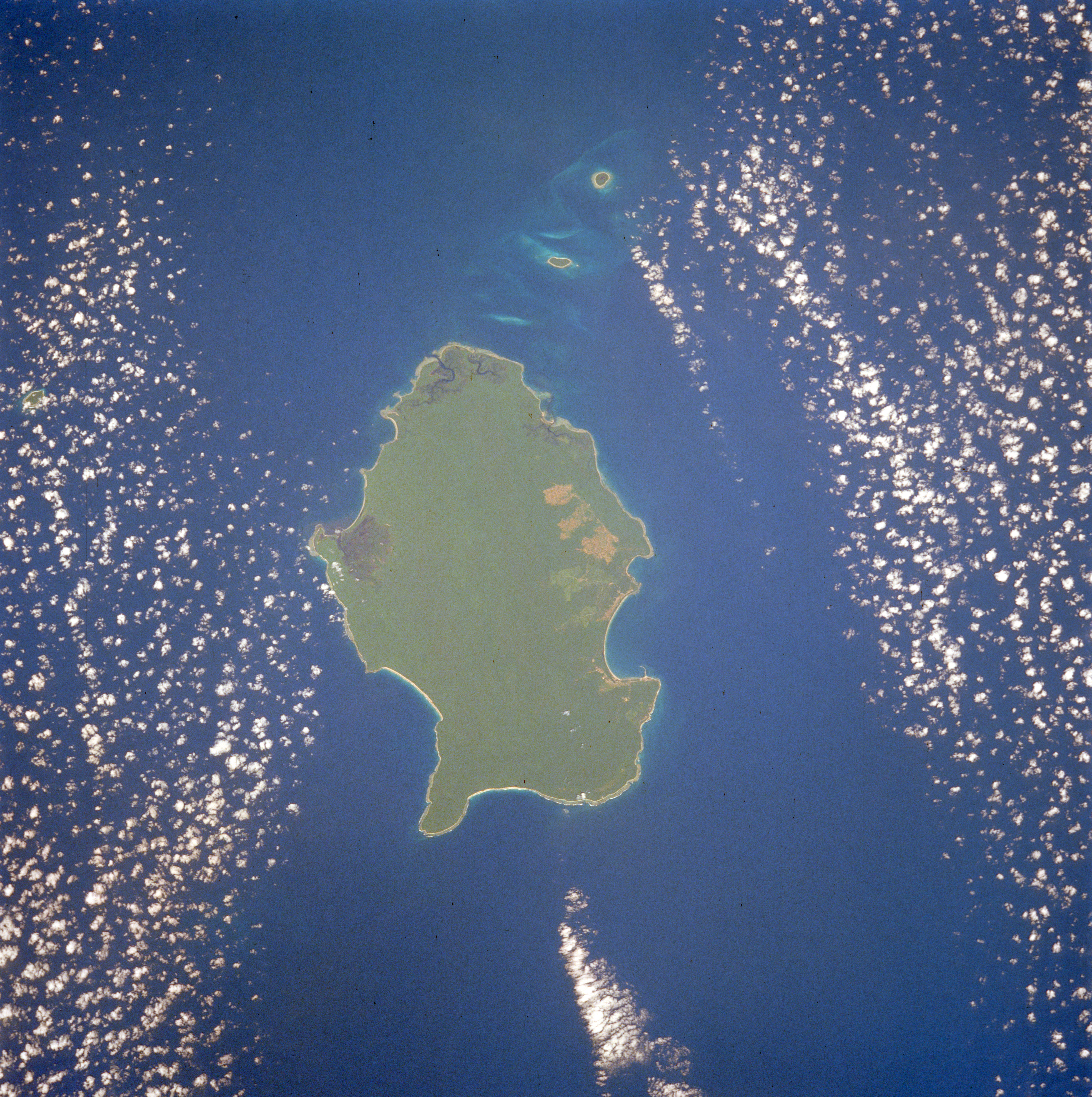
 1990 Space Shuttle image of Little Andaman

References
- "Islandwise Area and Population - 2011 Census" (PDF). Government of Andaman.
- Sailing Directions (Enroute), Pub. 173: India and the Bay of Bengal (PDF). Sailing Directions. United States National Geospatial-Intelligence Agency. 2017. p. 288.
- "A&N Islands - Pincodes". 22 September 2016. Archived from the original on 23 March 2014. Retrieved 22 September 2016.
{{cite web}}: CS1 maint: bot: original URL status unknown (link) - "STD Codes of Andaman and Nicobar". allcodesindia.in. Retrieved 23 September 2016.
- Registration Plate Numbers added to ISO Code
- "Village Code Directory: Andaman & Nicobar Islands" (PDF). Census of India. Retrieved 16 January 2011.
- "Government of India, Directorate General of Lighthouses and Lightships". www.dgll.nic.in. Retrieved 18 October 2016.
- "Station: Hut Bay Climatological Table 1981–2010" (PDF). Climatological Normals 1981–2010. India Meteorological Department. January 2015. pp. 329–330. Archived from the original (PDF) on 5 February 2020. Retrieved 8 February 2020.
- "Extremes of Temperature & Rainfall for Indian Stations (Up to 2012)" (PDF). India Meteorological Department. December 2016. p. M1. Archived from the original (PDF) on 5 February 2020. Retrieved 8 February 2020.
- "DEMOGRAPHIC – A&N ISLANDS" (PDF). andssw1.and.nic.in. Retrieved 23 September 2016.
- guide
 Little Andaman travel guide from Wikivoyage
На других языках
[de] Little Andaman
Klein-Andaman, engl. Little Andaman (in der Sprache der Onge: Gaubolambe[1] oder Egu Belong[2]) ist eine Insel der Andamanen im Golf von Bengalen, die zu Indien gehören. Östlich der Insel erstreckt sich die Andamanensee. Politisch gehört die Insel zum indischen Unionsterritorium Andamanen und Nikobaren. Sie ist die viertgrößte und südlichste Insel der Andamanen, mit einer Fläche von 734,4 km².[3][4] Die relativ flache Insel steigt ganz allmählich bis zur höchsten Erhebung von 183 Metern im Zentrum an.[5]- [en] Little Andaman
[fr] Petite Andaman
La Petite Andaman (en Onge: Gaubolambe) est la quatrième des îles Andaman par la taille. Sa superficie est de 739 km². Elle est située à l'extrémité sud de l'archipel, et est séparée de la Grande Andaman par le détroit de Duncan. Elle est le territoire de la tribu Onge et est classée comme réserve tribale depuis 1957.[it] Piccola Andaman
Piccola Andaman (lingua Önge: Gaubolambe) è un'isola delle Andamane, la quarta più grande dell'arcipelago. Fa parte del distretto di Andaman Meridionale, appartenente al territorio indiano delle Andamane e Nicobare.[1][ru] Малый Андаман
Ма́лый Анда́ман[1] (англ. Little Andaman island, хинди लिटल अंदमान, на языке Онге: Gaubolambe) — четвёртый по площади остров Андаманских островов площадью в 734,39 км²[2], находящийся в южной части архипелага. От острова Рутланд, архипелага Большой Андаман, отделён проливом Дункан.Другой контент может иметь иную лицензию. Перед использованием материалов сайта WikiSort.org внимательно изучите правила лицензирования конкретных элементов наполнения сайта.
WikiSort.org - проект по пересортировке и дополнению контента Википедии