geo.wikisort.org - Island
Iriomote Island (西表島, Iriomote-jima, Yaeyama: Irïmutii; Iriomote: Irimutii; Okinawan: Iriumuti) is the largest of the Yaeyama Islands of Japan, and the second largest in Okinawa Prefecture after Okinawa Island itself.
Native name: 西表島 | |
|---|---|
 Map of Iriomote Island | |
 Iriomote Island in relation to the other Yaeyama Islands | |
| Geography | |
| Location | Bordering the Pacific Ocean and East China Sea, southwest of mainland Japan and east of Taiwan |
| Coordinates | 24°20′24″N 123°48′36″E |
| Archipelago | Yaeyama Islands |
| Area | 289.27 km2 (111.69 sq mi)[1] |
| Coastline | 130.0 km (80.78 mi)[1] |
| Highest elevation | 469.5 m (1540.4 ft) |
| Highest point | Mt. Komi (古見岳, Komi-dake) |
| Administration | |
Japan | |
| Prefecture | Okinawa Prefecture |
| Town | Taketomi, Okinawa |
| Demographics | |
| Population | 2,347 (2005) |
| Ethnic groups | Ryukyuan, Japanese |
The island has an area of 289.27 km2 (111.69 sq mi) and a 2005 population of 2,347. The island does not have an airstrip, and most visitors — over 390,000 in 2006 — arrive from Ishigaki by ferry, a 31.4 km (19.5 mi) ride to Uwahara Port (上原港) on Iriomote's northeast coast or Ōhara Port (大原港) on the southeast coast. Administratively the island belongs to Taketomi Town, Okinawa Prefecture.[1] Infrastructure is limited to a single coastal road connecting the hamlets on the northern and eastern shores.
Wildlife
The island is famed for the Iriomote cat, a Critically Endangered wild cat found only on Iriomote.[2] As of 2007[update] the population size is estimated to be 100–109 individuals.[3]
The island has a venomous snake—Trimeresurus elegans, known locally as the habu, a species of pitviper whose bite has a fatality rate of 3% and a permanent disability rate of 6–8%.[4]
Satakentia liukiuensis, the only species in the genus Satakentia, is a palm tree that is endemic to the two islands of Ishigaki and Iriomote in the Yaeyama Islands.[5]
Culture
The Iriomote dialect of the Yaeyama language is spoken by some[quantify] people on the island.
History
The island had few settlements of fishermen and rice growers on the coastal areas, but it never had a large population until the Iriomote Coal Mine operated between 1889 and 1959.
During World War II some residents of Ishigaki were forcibly made to take refuge in Iriomote, many of whom contracted malaria. After the war, the US Forces in Japan eradicated malaria from the island, and the island has been malaria-free since then. The island, together with the rest of Okinawa Prefecture, remained a US-controlled territory until 1972. Iriomote was returned to Japan on June 17, 1972.
The possibility exists that a World War II-era U.S. submarine lies in about 350 m (1,150 ft) of water off the coast of Iriomote Island. During operations with an Okinawan company using a U.S. made "SCORPIO" ROV in 1995, a group of divers encountered a sonar contact with what appeared to be a metal structure, about 6.1 m (20 ft) in girth and about 35 m (115 ft) in length (exposed) at an angle of roughly 20-30 degrees. The SONAR image of a large unexpected obstruction to the operations prompted the divers to command evasive maneuvers and avoid the area for the safety of the ROV.[6]
The divers, thinking they would have another opportunity to work in the area at a later date, left the area and never returned to that site. Their ROV was lost in 1997 off Yonaguni Island, the last island belonging to Okinawa off the east coast of Taiwan. They were fairly certain that the object was a submarine, and quite possibly the USS Snook. No further dives in the area have yet been attempted.[6]
One of the largest volcanic eruption took place at a submarine volcano north of the island in 1924. It had an estimated Volcanic explosivity index of 5. The island's coast was covered in large quantities of pumice and it was also found as far as Hokkaido.[7]
Economy
Apart from tourism, the island economy is sustained by agricultural production, primarily of pineapple, sugarcane, mango, culture pearl growing [8] and fishing.
Geography and climate

90% of the island is covered by dense jungle and mangrove swamps. 80% of the island is protected state land, and 34.3% of the island forms the Iriomote National Park. The highest point on the island is Mt. Komi (古見岳 Komidake) at 469.5 m (1,540 ft). Around 21 km (13 mi) northwest (24.558°N 124.000°E) of Iriomote is an active undersea volcano which last erupted in 1924; the summit is 200 m (660 ft) below sea level. Yubu Island lies about 0.5 km east of Iriomote Island.
The island's Urauchi River is the largest river in Okinawa Prefecture, and the smaller Nakama and Nakara rivers also flow within the island. Iriomote is also home to Pinaisara Falls, the largest waterfall in Okinawa Prefecture.[9]
Iriomote has a tropical rainforest climate (Köppen climate classification Af). The average yearly temperature is 23.9 °C (75.0 °F), and the average monthly temperature ranges from 18.5 °C (65.3 °F) in January to 28.9 °C (84.0 °F) in July. Iriomote has a typhoon season that, on average, runs from June to September.
| Climate data for Iriomote (1991−2020 normals, extremes 1954−present) | |||||||||||||
|---|---|---|---|---|---|---|---|---|---|---|---|---|---|
| Month | Jan | Feb | Mar | Apr | May | Jun | Jul | Aug | Sep | Oct | Nov | Dec | Year |
| Record high °C (°F) | 27.6 (81.7) |
27.8 (82.0) |
29.7 (85.5) |
31.0 (87.8) |
33.1 (91.6) |
34.6 (94.3) |
35.7 (96.3) |
35.0 (95.0) |
34.3 (93.7) |
33.1 (91.6) |
31.2 (88.2) |
29.4 (84.9) |
35.7 (96.3) |
| Average high °C (°F) | 20.9 (69.6) |
21.6 (70.9) |
23.1 (73.6) |
25.5 (77.9) |
28.3 (82.9) |
30.5 (86.9) |
32.1 (89.8) |
31.5 (88.7) |
30.3 (86.5) |
27.8 (82.0) |
25.5 (77.9) |
22.4 (72.3) |
26.6 (79.9) |
| Daily mean °C (°F) | 18.5 (65.3) |
19.0 (66.2) |
20.2 (68.4) |
22.8 (73.0) |
25.5 (77.9) |
27.8 (82.0) |
28.9 (84.0) |
28.5 (83.3) |
27.6 (81.7) |
25.4 (77.7) |
23.1 (73.6) |
20.0 (68.0) |
23.9 (75.1) |
| Average low °C (°F) | 16.4 (61.5) |
16.7 (62.1) |
17.7 (63.9) |
20.3 (68.5) |
23.1 (73.6) |
25.8 (78.4) |
26.5 (79.7) |
26.1 (79.0) |
25.2 (77.4) |
23.4 (74.1) |
21.0 (69.8) |
17.9 (64.2) |
21.7 (71.0) |
| Record low °C (°F) | 6.7 (44.1) |
8.3 (46.9) |
7.5 (45.5) |
10.4 (50.7) |
14.0 (57.2) |
16.1 (61.0) |
21.0 (69.8) |
21.6 (70.9) |
17.8 (64.0) |
14.0 (57.2) |
11.0 (51.8) |
8.9 (48.0) |
6.7 (44.1) |
| Average precipitation mm (inches) | 162.9 (6.41) |
146.6 (5.77) |
147.3 (5.80) |
157.3 (6.19) |
175.6 (6.91) |
186.3 (7.33) |
128.8 (5.07) |
282.0 (11.10) |
270.8 (10.66) |
213.1 (8.39) |
192.3 (7.57) |
176.9 (6.96) |
2,240 (88.19) |
| Average precipitation days (≥ 1.0 mm) | 14.1 | 12.0 | 12.0 | 9.9 | 10.0 | 9.8 | 9.1 | 12.0 | 12.3 | 11.1 | 12.2 | 13.5 | 138 |
| Average relative humidity (%) | 73 | 77 | 77 | 78 | 81 | 82 | 81 | 83 | 80 | 75 | 77 | 75 | 78 |
| Mean monthly sunshine hours | 71.8 | 82.9 | 107.1 | 124.3 | 165.8 | 203.7 | 256.2 | 218.8 | 184.5 | 139.1 | 97.1 | 70.7 | 1,721.9 |
| Source: Japan Meteorological Agency[10][11] | |||||||||||||
Education
Schools on Iriomote Island are operated by Taketomi Town.
Combined elementary and junior high schools include: [12]
- Funauki Elementary and Junior High School (竹富町立船浮小中学校)
- Iriomote Elementary and Junior High School(竹富町立西表小中学校)
Junior high schools include:[12]
- Funaura Junior High School (竹富町立船浦中学校) - Uehara
- Ōhara Junior High School (竹富町立大原中学校) - Haemi
Elementary schools include:[12]
- Komi Elementary School (竹富町立古見小学校) - Komi
- Ohara Elementary School (竹富町立大原小学校) - Haemi
- Shirama Elementary School (竹富町立白浜小学校) - Shirahama (白浜)
- Uehara Elementary School (竹富町立上原小学校) - Uehara
For public senior high school students may attend schools of the Okinawa Prefectural Board of Education.
Gallery
 Tsuzumari-no-hama (Tsukigahama Beach)
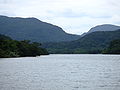 Urauchi-gawa: the longest river in Okinawa.
 Mariyudō-no-taki: Waterfall on the Urauchi River.
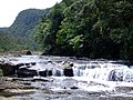 Kampire-no-taki: A section of the Kampire waterfall on the Urauchi River.
 Pinaisara-no-taki: Waterfall on the north of the island.
 Mangrove on the Nakama River
 Sakishimasuou tree: Said to be the biggest and oldest mangrove tree in Japan.
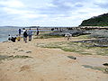 Hoshizuna-no-hama (Star Sand Beach): Beachcombers looking for star-shaped sand grains.
![Star sand from Hoshizuna-no-hama: Abraded calcium-carbonate tests of foraminifers from nearby reefs.[13]](//upload.wikimedia.org/wikipedia/commons/thumb/e/ec/Star_sand_Iriomote.jpg/120px-Star_sand_Iriomote.jpg) Star sand from Hoshizuna-no-hama: Abraded calcium-carbonate tests of foraminifers from nearby reefs.[13]
Star sand from Hoshizuna-no-hama: Abraded calcium-carbonate tests of foraminifers from nearby reefs.[13]


![Star sand from Hoshizuna-no-hama: Abraded calcium-carbonate tests of foraminifers from nearby reefs.[13]](http://upload.wikimedia.org/wikipedia/commons/e/ec/Star_sand_Iriomote.jpg)
References
- 知・旅・住 離島総合情報サイト 沖縄のしまじま [Know, Travel, Live: Remote Islands General Information Site: Okinawa's Islands] (in Japanese). Okinawa Prefecture. Archived from the original on June 28, 2004. Retrieved June 11, 2012.
- Izawa, M. (2008). "Prionailurus bengalensis ssp. iriomotensis". IUCN Red List of Threatened Species. 2008.
- 環境省. イリオモテヤマネコ生息状況等総合調査(第4次)の結果について(お知らせ) [(Fourth) Survey of the State of the Iriomote Cat's Habitat: Regarding the Results (notice)] (in Japanese). Retrieved June 10, 2012.
- U.S. Navy (1991). Poisonous Snakes of the World. New York: Dover Publications Inc. ISBN 0-486-26629-X.
- Dransfield, John; Uhl, Natalie W.; Asmussen, Conny B.; Baker, William J.; Harley, Madeline M.; Lewis, Carl E. (2008). Genera Palmarum: The Evolution and Classification of Palms. Royal Botanic Gardens, Kew. ISBN 978-1-84246-182-2.
- "USS Snook (SS 279)". Commander, Submarine Force, U.S. Pacific Fleet. Archived from the original on July 24, 2008. Retrieved September 21, 2021.
 This article incorporates text from this source, which is in the public domain.
 - "Submarine Volcano NNE of Iriomotejima". Global Volcanism Program. Smithsonian Institution.
- "Pearl Oysters | 螺鈿と漆芸修業奮闘記". Archived from the original on October 6, 2014. Retrieved October 3, 2014.
- "Introducing places of interest: Iriomote-Ishigaki National Park (Iriomote)". Ministry of the Environment. Archived from the original on May 27, 2012. Retrieved June 11, 2012.
- 観測史上1~10位の値(年間を通じての値). JMA. Retrieved March 23, 2022.
- 気象庁 / 平年値(年・月ごとの値). JMA. Retrieved March 23, 2022.
- "小中学校・小学校・中学校". Taketomi Town. Retrieved July 14, 2021.
- Hohenegger, J., Larger foraminifera as important calcium-carbonate producers in coral reef environments and constituting the main components of carbonate beach sands; examples from the Ryukyu archipelago. Archived 2012-03-22 at the Wayback Machine Institut für Paläontologie, Universität Wien.
External links
 Iriomote Island travel guide from Wikivoyage
На других языках
[de] Iriomote
Iriomote bzw. Iriomote-jima (jap. 西表島) ist mit 289,28 km²[1] die größte Insel der Yaeyama-Gruppe in der Präfektur Okinawa, fast am südwestlichen Ende der japanischen Inselkette. Aufgrund ihres außerordentlichen Artenreichtums wurde Iriomote auch „Galapagos des Ostens“ genannt.[2]- [en] Iriomote Island
[fr] Iriomote-jima
L'île d'Iriomote (西表島, Iriomote-jima?) est par sa surface la plus grande île de l'archipel des Îles Yaeyama au sud-ouest du Japon, faisant partie de l'archipel Sakishima, avec les îles Miyako à l'est et les îles Senkaku plus au nord, et donc des îles Ryūkyū. Elle fait partie du bourg de Taketomi dans la préfecture d'Okinawa et compte environ 2 000 habitants pour une surface de 289 km2. Il y a un port principal et une route principale sur l'île. La route principale ne fait pas le tour de l'île, seulement la moitié environ, aussi certains villages ne sont accessibles que par la voie des eaux. La très large majorité de la surface de l'île est sauvage, couverte de mangroves, d'une forêt dense et de (petites) montagnes. L'île fait partie du parc national d'Iriomote-Ishigaki.[it] Iriomote
Iriomote (西表島, Iriomote-jima; yaeyama: Irimuti; okinawense: Iriumuti) è la più grande delle Isole Yaeyama e la seconda per estensione tra quelle appartenenti alla Prefettura di Okinawa, dopo l'Isola di Okinawa stessa.[ru] Ириомоте
Ириомо́те (яп. 西表島 Ириомотэ-дзима) — самый крупный японский остров группы островов Яэяма в Восточно-Китайском море. Является частью префектуры Окинава. Остров расположен южнее Тайбэя на расстоянии 180 км ближе к Тайваню, чем к основному острову префектуры (430 км).Другой контент может иметь иную лицензию. Перед использованием материалов сайта WikiSort.org внимательно изучите правила лицензирования конкретных элементов наполнения сайта.
WikiSort.org - проект по пересортировке и дополнению контента Википедии