geo.wikisort.org - Island
Clare Island (Irish: Cliara or Oileán Chliara), also historically Inishcleer,[1] is a mountainous island guarding the entrance to Clew Bay in County Mayo, Ireland. Historically part of the kingdom of Umhaill, it is famous as the home of the 15th century pirate queen Gráinne O'Malley. The current population of the island is roughly 160.
Native name: Cliara[1] | |
|---|---|
 Clare Island from Clew Bay | |
 | |
 Clare Island Location in Ireland | |
| Geography | |
| Location | Atlantic Ocean |
| Coordinates | 53.°48.13′N 9°59.17′W |
| Archipelago | Clew Bay |
| Total islands | 141[2] |
| Area | 4,053 acres (1,640 ha) |
| Coastline | 21 km (13 mi) |
| Highest elevation | 462 m (1516 ft) |
| Highest point | Knockmore |
| Administration | |
Ireland | |
| Province | Connacht |
| County | Mayo |
| Demographics | |
| Population | 159 (2016) |
| Pop. density | 7.8/km2 (20.2/sq mi) |
To the south-west lies Inishturk (inhabited) and Caher Island (uninhabited), and to the north is Achill Island.
History
This section does not cite any sources. (September 2022) |
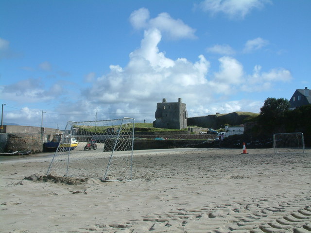
Through the Middle Ages, Clare Island was part of the lands of the O'Malley family. The ruins of an O'Malley tower-house, known as Granuaile's Castle because of its most famous resident, are close to the pier at the eastern edge of the island. Clare Island Abbey near the south coast of the island was founded by the O'Malleys and contains the O'Malley Tomb, a possible burial site of Gráinne O'Malley. The Abbey is known for its rare medieval roof paintings. In 1588, a ship from the Spanish Armada was wrecked on Clare Island and its men were killed by the O'Malleys.
A very prominent landmark of the island is the Clare Island Lighthouse, established by John Denis Browne, the 1st Marquess of Sligo, in 1806. On 29 September 1813 a fire, caused by careless disposal of the oil-lamp wicks, destroyed part of the tower and the lantern. The rebuilt light was ready in 1818.
In 1834, the tower was struck by lightning. After 159 years of faithful service the lighthouse was taken out of service on 28 September 1965, replaced by the modern Achillbeg Island lighthouse on the south side of Achill Island.
Clare Island Lighthouse has been refurbished and is now an upmarket guesthouse, while its optic is on permanent rotating display at the World of Glass museum and visitor centre in North West England.
Demographics
The table below reports data on Clare Island's population taken from Discover the Islands of Ireland (Alex Ritsema, Collins Press, 1999) and the Census of Ireland.
|
|
| ||||||||||||||||||||||||||||||||||||||||||||||||||||||||||||||||||||||||||||||||||||
| Source: Central Statistics Office. "CNA17: Population by Off Shore Island, Sex and Year". CSO.ie. Retrieved 12 October 2016. | ||||||||||||||||||||||||||||||||||||||||||||||||||||||||||||||||||||||||||||||||||||||
Fauna and Flora
Between 1909 and 1911, the Belfast naturalist Robert Lloyd Praeger led an exhaustive biological survey of the island, the Clare Island Survey, which was unprecedented at the time and served as a template for future studies. A new study of the Island was made in 1990 to 2005 and the results were published in six volumes, the last of which was published in 2007.[3] This is reputedly the only survey of its kind in Europe and is serving as a model for measuring the effects of climate change on environment.[4]
Algae
Three species of freshwater red algae have been recorded from Clare Island: Batrachospermum atrum (Hudson) Harvey, B. turfosum Bory and Lemanea fucina Bory.[3]
Transportation and Infrastructure
Clare Island is accessible by daily ferry services from Roonagh Pier near Louisburgh. The island has a hostel, a few bed and breakfasts and a yoga and meditation centre. The island also has a bicycle rental facility.[5]
The island has its own primary school and a post office. Children go to the mainland for secondary school education. The harbour, located on the SE of the island, offers good shelter in all winds with West in them, but is completely open to easterly winds. The piers are not suitable for yachts to come alongside[6] but in the summer Mayo county council maintains a number of moorings for visiting yachts. The inner harbour dries out with a sandy bottom.[7]
Culture
The island features in the song "Clare Island" by the Irish folk-rock band, the Saw Doctors from their 1996 album, Same Oul' Town. In the song, the island is described as a haven from hectic city life. It is also mentioned in the lyrics of the song "The Green and Red of Mayo".
Clare Island is the setting for Bob Quinn's film Budawanny (1987). He also shot a documentary on Clare Island, titled The Island, in 1966.[8]
Clare Island is the setting for the Michael Morpurgo book The Ghost of Grania O'Malley.[citation needed]
The Clare Island Film Festival has been run annually since 2014.[9]
Gallery
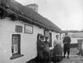 Post office c. 1900
 Granuaile's Castle
 The optic from the Clare Island lighthouse now on permanent rotating display at The World of Glass gift shop, St. Helens, UK
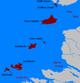 Islands off County Mayo
Click for larger view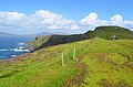 Visiting Clare Island.
 Visiting Clare Island.
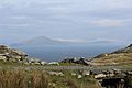 Clare Island as seen from Inishturk


See also
References
- Clare Island/Cliara. Placenames Database of Ireland.
- "The Story of Clew Bay from Granuaile to John Lennon". The Irish Times. Retrieved 11 May 2020.
- Ed. Guiry, M.D., John, D.M., Rindi, F. and McCarthy, T. K. New Survey of Clare Island Volume 6: The Freshwater and Terrestrial Algae. Royal Irish Academy ISBN 978-1-904890-31-7
- "The Ghost of Grania O'Malley".
- "Clare island tourism".
- "Amenities and Activities".
- "Clare Island harbour".
- "Filmography and DVDs | conamara.org".
- "The Clare Island Film Festival". Clare Island Info. Retrieved 12 August 2018.
External links
- Information site on Clare Island, updated regularly with news and events
- Another information site on Clare Island, maintained by an islander
- In this series of podcasts on Mayo's Heritage, an excerpt can be heard from Ger Reidy's visit to Clare Island as part of his Heritage Tour of Clew Bay

Authority control | |
|---|---|
| General |
|
| National libraries | |
| Other |
|
На других языках
[de] Clare Island
Clare Island (irisch Cliara oder Oileán Chliara) ist eine Insel vor der Westküste des County Mayo in Irland. Sie liegt am Eingang der Clew Bay und ist neben Achill Island und Inishturk die größte (16,4 km²) bewohnte Insel. Sie ist auch die Insel mit der höchsten Erhebung (461 Meter) und den steilsten Klippen in der Bay und liegt circa 3,5 Meilen vom nächsten Festland-Hafen entfernt. Es leben noch 168 Menschen auf dem kleinen Eiland (Stand 2011). Die Hälfte seiner einst mehr als 1500 Bewohner verlor Clare während der großen Hungersnot ab 1845.- [en] Clare Island
[fr] Île de Clare
Clare Island (Oileán Chliara en irlandais) est une île montagneuse à l'entrée de Clew Bay dans le Comté de Mayo, en Irlande. Elle a été rendue célèbre par la reine des pirates, Gráinne O'Malley. Approximativement, 145 personnes vivent sur l'île. Au sud-ouest de Clare Island se trouvent les îles inhabitées de Caher Island et de Inishturk.[it] Clare Island
Clare Island (Cliara in gaelico irlandese) è una suggestiva isola situata sull'ingresso della Clew Bay, nel Mayo, Irlanda. Celebre per essere stata il covo della regina pirata Grace O'Malley, oggi annovera 120 abitanti circa.[ru] Клэр (остров)
Клэр (ирл. Oileán Chliara[1], англ. Clare Island) — остров вблизи западного побережья Ирландии, в заливе Клю, графство Мейо. Наиболее известен замком Грануаль, базой известной ирландской предводительницы пиратов (здесь расположены её замок и семейная часовня, в которой она, вероятно, была захоронена)[2]. Население — 168 чел. (2011).[3]Другой контент может иметь иную лицензию. Перед использованием материалов сайта WikiSort.org внимательно изучите правила лицензирования конкретных элементов наполнения сайта.
WikiSort.org - проект по пересортировке и дополнению контента Википедии