geo.wikisort.org - Insel
Clare Island (irisch Cliara oder Oileán Chliara) ist eine Insel vor der Westküste des County Mayo in Irland. Sie liegt am Eingang der Clew Bay und ist neben Achill Island und Inishturk die größte (16,4 km²) bewohnte Insel. Sie ist auch die Insel mit der höchsten Erhebung (461 Meter) und den steilsten Klippen in der Bay und liegt circa 3,5 Meilen vom nächsten Festland-Hafen entfernt. Es leben noch 168 Menschen auf dem kleinen Eiland (Stand 2011). Die Hälfte seiner einst mehr als 1500 Bewohner verlor Clare während der großen Hungersnot ab 1845.
| Clare Island | ||
|---|---|---|
 | ||
| Gewässer | Atlantischer Ozean | |
| Geographische Lage | 53° 48′ 18″ N, 9° 59′ 37″ W | |
| ||
| Länge | 7,8 km | |
| Breite | 4 km | |
| Fläche | 16,4 km² | |
| Höchste Erhebung | Knockmore (An Cnoc Mór) 462 m | |
| Einwohner | 168 (2011[1]) 10 Einw./km² | |
| Hauptort | Capnagower | |
 | ||

Auf Clare liegen das internationale Zentrum für Inselforschung und die Ruine der Zisterzienserabtei Clare Island Abbey aus dem 14. Jahrhundert. Der Leuchtturm der Insel mit seiner Gebäudegruppe wird als Hotel genutzt und ist heute in Privatbesitz. Bei Lecarrow befindet sich ein Court tomb und mehrere von Dutzenden Ancient cooking places. Es gibt mehrere Promontory Forts (Strake) und Menhire.
Zu der Insel besteht nur eine unregelmäßige Fährverbindung. Die Fähre „Pirate Queen“ gehört der Familie O’Grady und ist benannt nach Grace O’Malley (Granuaile oder Grainneuaile), der Piratenkönigin des 16. Jahrhunderts. Sie lebte in einem Castle am Hafen von Clare.
Bildergalerie
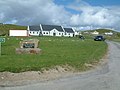 Capnagower (community center)
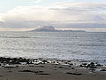 Clare Island
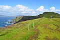 Clare Island.
 Clare Island.


Literatur
- Anne Chambers: Granuaile – The Life and Times of Grace O'Malley. Wolfhound Press, Dublin 1979, ISBN 0-905473-31-0
Weblinks
Einzelnachweise
- Table No. 11 Population of inhabited Islands off the coast, 2006 and 2011. In: Central Statistics Office (Hrsg.): Population Classified by area. Dublin 2012, S. 132–133 (PDF-Datei; 3,64 MB (Memento vom 10. Oktober 2012 im Internet Archive))
На других языках
- [de] Clare Island
[en] Clare Island
Clare Island (Irish: Cliara or Oileán Chliara), also historically Inishcleer,[1] is a mountainous island guarding the entrance to Clew Bay in County Mayo, Ireland. Historically part of the kingdom of Umhaill, it is famous as the home of the 15th century pirate queen Gráinne O'Malley. The current population of the island is roughly 150.[fr] Île de Clare
Clare Island (Oileán Chliara en irlandais) est une île montagneuse à l'entrée de Clew Bay dans le Comté de Mayo, en Irlande. Elle a été rendue célèbre par la reine des pirates, Gráinne O'Malley. Approximativement, 145 personnes vivent sur l'île. Au sud-ouest de Clare Island se trouvent les îles inhabitées de Caher Island et de Inishturk.[it] Clare Island
Clare Island (Cliara in gaelico irlandese) è una suggestiva isola situata sull'ingresso della Clew Bay, nel Mayo, Irlanda. Celebre per essere stata il covo della regina pirata Grace O'Malley, oggi annovera 120 abitanti circa.[ru] Клэр (остров)
Клэр (ирл. Oileán Chliara[1], англ. Clare Island) — остров вблизи западного побережья Ирландии, в заливе Клю, графство Мейо. Наиболее известен замком Грануаль, базой известной ирландской предводительницы пиратов (здесь расположены её замок и семейная часовня, в которой она, вероятно, была захоронена)[2]. Население — 168 чел. (2011).[3]Другой контент может иметь иную лицензию. Перед использованием материалов сайта WikiSort.org внимательно изучите правила лицензирования конкретных элементов наполнения сайта.
WikiSort.org - проект по пересортировке и дополнению контента Википедии