geo.wikisort.org - Island
Inishturk (Inis Toirc in Irish, meaning Wild Boar Island) is an inhabited island of County Mayo, in Ireland.[3]
Native name: Inis Toirc | |
|---|---|
 North coast of Inishturk | |
 Inishturk | |
| Geography | |
| Location | Atlantic Ocean |
| Coordinates | 53.7014°N 10.1083°W |
| Area | 6 km2 (2.3 sq mi)[1] |
| Highest elevation | 189.3 m (621.1 ft)[2] |
| Administration | |
Ireland | |
| Province | Connacht |
| County | Mayo |
| Demographics | |
| Population | 51 (2016) |
| Pop. density | 8.5/km2 (22/sq mi) |
| Ethnic groups | Irish |
Geography
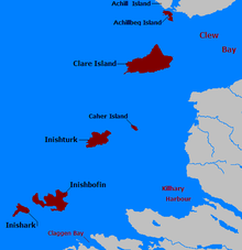
The island lies about 15 km (9 mi) off the coast; its highest point reaches 189.3 m (621.1 ft) above sea level.[2] Between Inisturk and Clare Island lies Caher Island. It has a permanent population of 58 people.[4] There are two main settlements, both on the more sheltered eastern end of the island, Ballyheer and Garranty. Bellavaun and Craggy are abandoned settlements. The British built a Martello tower on the western coast during the Napoleonic Wars.
History
Inishturk has been inhabited on and off since 4,000 BCE and has been inhabited permanently since at least 1700.[5] Some of the more recent inhabitants are descended from evacuees from Inishark to the southwest.[citation needed]
Recent history
In 1993, Inishturk Community centre was opened, this community centre doubles as a library and a pub. In June 2014 the ESB commissioned three new Broadcrown BCP 110-50 100kVA diesel generators to supply electricity to the island[6] The ESB have operated a diesel power station on the island since the 1980s[7]
Inishturk gained international attention in 2016 after a number of websites claimed that the island would welcome any American "refugees" fleeing a potential Donald Trump presidency.[8][9][10] These were examples of the type of "fake news" that arose during the 2016 US presidential election campaign.[11]
The island is home to a primary school on the island which in 2011 had only 3 pupils; this is believed to be the smallest primary school in Ireland.[12]
Demographics
The table below reports data on Inisturk's population taken from Discover the Islands of Ireland (Alex Ritsema, Collins Press, 1999) and the Census of Ireland.
|
|
| ||||||||||||||||||||||||||||||||||||||||||||||||||||||||||||||||||||||||||||||||||||
| Source: Central Statistics Office. "CNA17: Population by Off Shore Island, Sex and Year". CSO.ie. Retrieved 12 October 2016. | ||||||||||||||||||||||||||||||||||||||||||||||||||||||||||||||||||||||||||||||||||||||
Transport
Prior to 1997 there was no scheduled ferry service and people traveled to and from the islands using local fishing boats. Since then a ferry service operates from Roonagh Quay, Louisburgh, County Mayo.[13] The pier was constructed during the 1980s by the Irish government, around this time the roads on the island were paved.[14]
Gallery
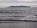 Inisturk and Caher island
 Inishturk pier
 Harbour with Caher Island in background
 Community centre
 Freshwater lake
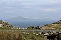 Clare Island as seen from Inishturk
 Power station


See also
References
- R. Lloyd Praeger (March 1907). "The Flora of Inishturk". The Irish Naturalist. 16 (3): 113–125. JSTOR 25523043.
Inishturk lies off the Mayo coast [..] It is also much smaller than either [of its neighbours], having an area of 21⁄4 square miles, as against Bofin's 41⁄2 square miles (Inishark included), and Clare's 61⁄6 square miles
- "Inisturk". MountainViews. Ordnance Survey Ireland. Retrieved 23 February 2015.
- Sometimes the island's name is reported as Inisturk, as for instance by Google Maps
- "No Christmas medical cover on island of Inishturk". breakingnews.ie. 24 December 2014.
- Mayo Walks - Inishturk
- BC Inishturk case study
- New hope for Inishturk, esbelectricmail.com. Accessed 29 September 2022.
- "Inishturk: The Tiny Irish Island That Will Welcome American Refugees". Retrieved 29 September 2022.
- Huffington Post - Looking to escape Donald Trump, Huffingtonpost.com. Accessed 29 September 2022.
- Remote Irish island seeks American fleeing Donald Trump presidency, Irishcentral.com. Accessed 29 September 2022.
- "Fake news is big business - and may have handed Trump the election". The Business Post. 20 November 2016.
- Three-pupil school urges families to consider move to 'idyllic' island, irishtimes.com. Accessed 29 September 2022.
- islander committed to her community
- Winter Inishturk
External links
 Media related to Inishturk at Wikimedia Commons
- Podcast series on Mayo's Heritage, including a heritage Tour of Inishturk
- Mayo News - Inishturk islander committed to her community
- Island life Inishbofin Inishturk
- Irish Islands - Inishturk

Authority control | |
|---|---|
| General |
|
| National libraries | |
На других языках
[de] Inishturk
Inishturk (irisch: Inis Toirc; deutsch: „Wildschwein-Insel“) ist eine bewohnte Insel in der Clew Bay vor der Küste des County Mayo in Irland.- [en] Inishturk
[fr] Inishturk
Inishturk (en Irlandais : Inis Toirc) est une île irlandaise de l'océan Atlantique au large des côtes du comté de Mayo. L'île est habitée toute l'année et sa population s'élève à environ 70 individus dont certains sont les descendants directs des derniers habitants de l'île voisine Inishark évacuée en 1960. En irlandais, le nom de l'île signifie île au sanglier.[it] Inishturk
Inishturk (Inis Toirc in gaelico irlandese, che significa "isola del verro selvatico") è un'isola abitata al largo delle coste del Mayo, in Irlanda, di cui fa parte.[ru] Иништурк
Иништурк (ирл. Inis Toirc[1], англ. Inishturk, — «остров диких кабанов»[2]) — остров вблизи западного побережья Ирландии, в заливе Клю, графство Мейо. Расположен южнее островов Клэр и Кахер, между Клэром и Инишбофином[3]. Население — 53 чел. (2011).[4]. На острове четыре достопримечательности — форт IX века, старая церковь, действующее кладбище и сигнальная башня[5]. На острове некогда преобладал английский язык, но после переселения людей от Великого голода основным языком к началу XX века здесь стал ирландский. Геологически остров относится к ордовикскому периоду[2].Другой контент может иметь иную лицензию. Перед использованием материалов сайта WikiSort.org внимательно изучите правила лицензирования конкретных элементов наполнения сайта.
WikiSort.org - проект по пересортировке и дополнению контента Википедии