geo.wikisort.org - Island
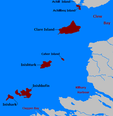
Caher Island (Cathair na Naomh in Irish), an uninhabited island off the coast of County Mayo in Ireland, is situated between the larger Clare Island and Inishturk.
Native name: Cathair na Naomh | |
|---|---|
 Looking towards Caher Island from Inishturk | |
 Caher Caher Island (Ireland) | |
| Geography | |
| Location | Atlantic Ocean |
| Coordinates | 53.°43.3′N 10°1.38′W |
| Archipelago | Clew Bay |
| Total islands | 117 |
| Major islands | Clare Island, Inishturk, Inishbofin, Inishark, Achillbeg, Caher Island |
| Area | 128 acres (52 ha)[1] |
| Highest elevation | 61 m (200 ft) |
| Highest point | Unnamed Peak |
| Administration | |
Ireland | |
| Province | Connacht |
| County | Mayo |
| Demographics | |
| Population | 0 |
| Pop. density | 0/km2 (0/sq mi) |
Etymology
Cathair na Naomh in Irish means the City of the Saints.
History
Click for larger view
An ancient centre for pilgrimage, it is still visited for this reason today.[2] On 15 August each year, the Feast of the Assumption, there is a pilgrimage to the island.[citation needed]
The island has an Early Christian monastery with the remains of a chapel in an enclosure and several carved slabs. The island appears to hold the remains of hermitages of seventh century monks.[citation needed]
After being widowed in 1565, the legendary pirate queen and Irish clan leader Gráinne Mhaol (Grace O'Malley) allegedly took a shipwrecked sailor as her lover. The affair only lasted briefly as he was killed in a deliberate provocation by Clan MacMahon of Ballyvoy. Seeking vengeance, O'Malley attacked Clan MacMahon's stronghold of Doona Castle in Blacksod Bay and slew her lover's killers upon Caher Island. Her vengeance against Clan MacMahon earned Gráinne Mhaol the sinister nickname the 'Dark Lady of Doona'.[3]
Access to the island
The island is accessed by boat from Inishturk. Caher can only be accessed reasonably safely by approaching with a small boat, such as a currach, from the east to the point marked as Portatemple on the charts. This is not a safe harbour, as heavy Atlantic swells can break through even on rare calm days. The comment on the chart for the area, "The entire area of irregular depths up to 4 miles offshore between Clew Bay and Killary harbour 10 miles further south, breaks in bad weather" reflects the fact that even in moderate swell conditions of less than 5 metres, peaks can rise and break unexpectedly.
References
- The Holy Wells of Ireland, Patrick Logan, Colin Smythe, 1980, pag. 146
- Inishturk Island - Caher Island
- Gráinne Mhaol Ní Maille, Dictionary of Irish Biography.
See also
Places in County Mayo | ||
|---|---|---|
County town: Castlebar | ||
| Towns |
|  |
| Villages and townlands |
| |
| Baronies |
| |
| Landforms | ||
| ||
This article related to the geography of County Mayo, Ireland is a stub. You can help Wikipedia by expanding it. |
На других языках
[de] Caher Island
Caher Island (irisch Oileán na Cathrach, auch Cathair na Naomh – deutsch Stadt der Heiligen) ist eine Insel, acht Kilometer vor der Westküste Irlands. Sie liegt in der Clew Bay zwischen den Inseln Clare Island und Inishturk im County Mayo.- [en] Caher Island
[fr] Île de Caher
L'île de Caher (Caher Island en anglais, Cathair na Naomh en irlandais), une île inhabitée au large des côtes du comté de Mayo, en Irlande, est située entre la plus grande île de l'archipel, Clare et Inishturk. Un ancien lieu de pèlerinage fait que l'île est encore visitée de nos jours. Le 15 août de chaque année, à l'Assomption, la tradition du pèlerinage est encore respectée. Le nom de l'île, en irlandais, signifie « la cité des saints ». Il est possible de s'y rendre par bateau, à partir d'Inishturk.[it] Caher Island
L'isola di Caher (Cathair na Naomh in gaelico irlandese) è un'isola situata al largo della costa della contea di Mayo, Irlanda.[ru] Кахер (остров)
Кахер (ирл. Oileán na Cathrach[1], англ. Caher) — необитаемый остров вблизи западного побережья Ирландии, в заливе Клю, графство Мейо. Расположен между островами Клэр и Иништурк. Ранее (в VI-VII вв.) здесь были расположены монашеские поселения; существует традиция паломничества сюда 15 августа. Плоский камень на южно-восточной части развалин местной часовни назван в честь святого Патрика Leaba Phádraic[2].Другой контент может иметь иную лицензию. Перед использованием материалов сайта WikiSort.org внимательно изучите правила лицензирования конкретных элементов наполнения сайта.
WikiSort.org - проект по пересортировке и дополнению контента Википедии