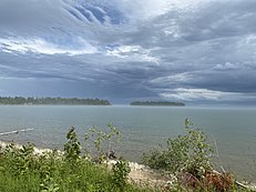
 View from shore in July
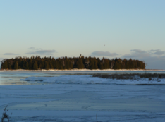 View from shore in December
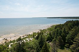 Shore of the island as seen from the lighthouse
 Small buildings on the island as seen from the lighthouse
 View towards the mainland as seen from the lighthouse
 View of mainland Baileys Harbor from Cana Island
 Aerial view in August
 July, island at lower right
![View of the tombolo and island from the mainland on August 18, 2006; during August 2006 Lake Michigan had an average water level of 176.13 meters above sea level.[6]](//upload.wikimedia.org/wikipedia/en/thumb/6/6d/CanaIslandLighthouseWalk.jpg/337px-CanaIslandLighthouseWalk.jpg) View of the tombolo and island from the mainland on August 18, 2006; during August 2006 Lake Michigan had an average water level of 176.13 meters above sea level.[6]
View of the tombolo and island from the mainland on August 18, 2006; during August 2006 Lake Michigan had an average water level of 176.13 meters above sea level.[6]![View of the tombolo and island on May 24, 2013; during May 2013 Lake Michigan had an average water level of 175.93 meters above sea level[6]](//upload.wikimedia.org/wikipedia/commons/thumb/3/35/Tombolo_to_Cana_Island_in_Door_County%2C_Wisconsin_on_May_24%2C_2013_during_the_lower_lake_level_conditions.jpg/231px-Tombolo_to_Cana_Island_in_Door_County%2C_Wisconsin_on_May_24%2C_2013_during_the_lower_lake_level_conditions.jpg) View of the tombolo and island on May 24, 2013; during May 2013 Lake Michigan had an average water level of 175.93 meters above sea level[6]
View of the tombolo and island on May 24, 2013; during May 2013 Lake Michigan had an average water level of 175.93 meters above sea level[6]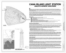 Diagram of the island in 1883
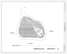 Later diagram of the island
geo.wikisort.org - Island
Cana Island is an island in Lake Michigan in the town of Baileys Harbor in Door County, Wisconsin, United States.[2] The Cana Island Light is on the east side of the island. It is possible to walk to Cana Island from the mainland over the tombolo when water levels are low.[3] Tombolo conditions are monitored by a webcam operated by the county parks department.[4] The island is part of the Town of Baileys Harbor, Wisconsin.
 | |
 Cana Island  Cana Island | |
| Geography | |
|---|---|
| Location | Door County, Wisconsin |
| Coordinates | 45°05′17″N 87°02′58″W |
| Area | 8.7[1] acres (3.5 ha) |
| Highest elevation | 581 ft (177.1 m) |
| Administration | |
United States | |
| State | Wisconsin |
| County | Door |
| Town | Baileys Harbor |
In 1896 the wooden bulk freighter Australasia burned and sank off Cana Island.[5]
Gallery


![View of the tombolo and island from the mainland on August 18, 2006; during August 2006 Lake Michigan had an average water level of 176.13 meters above sea level.[6]](http://upload.wikimedia.org/wikipedia/en/6/6d/CanaIslandLighthouseWalk.jpg)
![View of the tombolo and island on May 24, 2013; during May 2013 Lake Michigan had an average water level of 175.93 meters above sea level[6]](http://upload.wikimedia.org/wikipedia/commons/3/35/Tombolo_to_Cana_Island_in_Door_County%2C_Wisconsin_on_May_24%2C_2013_during_the_lower_lake_level_conditions.jpg)


Climate
| ||||||||||||||||||||||||||||||||||||||||||||||||||||||||||||||||||||||||||||||||||||||||||||||||||||||||||||||||||||||||||||
References
- "Cana Island". Door County Maritime Museum. Retrieved 30 August 2021.
- "Cana Island". Geographic Names Information System. United States Geological Survey, United States Department of the Interior.
- "Cana Island Light Station".
- Cana Island Camera, Door County Parks Department
- "Australasia (1884)". Wisconsin Shipwrecks. Retrieved March 10, 2018.
- Lake Michigan-Huron: Monthly Lake-Wide Average Water Levels (1918 - Present), Great Lakes Environmental Research Laboratory, National Oceanic and Atmospheric Administration, accessed February 25, 2022
- "NASA EarthData Search". NASA. Retrieved 30 January 2016.
External links
- Cana Island, Web-Map of Door County, Wisconsin
Lake Michigan Islands | ||||
|---|---|---|---|---|
| Michigan |
|  | ||
| Wisconsin |
| |||
| Authority control |
|---|
This article about a location in Door County, Wisconsin is a stub. You can help Wikipedia by expanding it. |
На других языках
- [en] Cana Island
[fr] Cana Island
Cana Island est une île du lac Michigan. L'île fait partie de la ville de Baileys Harbor (en) dans le Comté de Door, Wisconsin.Текст в блоке "Читать" взят с сайта "Википедия" и доступен по лицензии Creative Commons Attribution-ShareAlike; в отдельных случаях могут действовать дополнительные условия.
Другой контент может иметь иную лицензию. Перед использованием материалов сайта WikiSort.org внимательно изучите правила лицензирования конкретных элементов наполнения сайта.
Другой контент может иметь иную лицензию. Перед использованием материалов сайта WikiSort.org внимательно изучите правила лицензирования конкретных элементов наполнения сайта.
2019-2026
WikiSort.org - проект по пересортировке и дополнению контента Википедии
WikiSort.org - проект по пересортировке и дополнению контента Википедии