geo.wikisort.org - Island
Austvågøya is the northeasternmost and largest of the larger islands in the Lofoten archipelago in Nordland county, Norway. It is located between the Vestfjorden and the Norwegian Sea. The island of Vestvågøya lies to the southwest and the large island of Hinnøya to the northeast. In 2017, the island had about 9,000 residents.[1]
This article relies largely or entirely on a single source. (August 2021) |
 | |
 | |
 Austvågøya Location of the island  Austvågøya Austvågøya (Norway) | |
| Geography | |
|---|---|
| Location | Nordland, Norway |
| Coordinates | 68.2447°N 14.4882°E |
| Archipelago | Lofoten |
| Area | 526.7 km2 (203.4 sq mi) |
| Length | 40 km (25 mi) |
| Width | 30 km (19 mi) |
| Highest elevation | 1,146 m (3760 ft) |
| Highest point | Higravstinden |
| Administration | |
Norway | |
| County | Nordland |
| Municipalities | Vågan and Hadsel |
| Demographics | |
| Population | 9,264[1] (2017) |
| Pop. density | 17.6/km2 (45.6/sq mi) |
Most of the island is part of Vågan Municipality, while the northeastern part belongs to Hadsel Municipality. The main town on the island is Svolvær. Austvågøya is popular among mountain climbers. The famous Trollfjord is located in the eastern part of the island. Austvågøya is connected by the European route E10 highway to the neighboring island of Hinnøya to the east using the Raftsund Bridge and to the island of Gimsøya to the west using the Gimsøystraumen Bridge.[1]
Geography
The 526.7-square-kilometre (203.4 sq mi) island is 40 kilometres (25 mi) long in the east to west direction and 30 kilometres (19 mi) wide from the north to south. The islands surrounding Austvågøya include Gimsøya and Vestvågøya to the west, Skrova, Litlmolla, and Stormolla to the south, Hinnøya to the east, and Hadseløya to the north.
Austvågøya is largely a mountain massif, with lowland almost exclusively at the coastal beaches, the brim of lowland around the coast. The highest mountain on the island (and in all of Lofoten) is the 1,146-metre (3,760 ft) tall Higravstinden, located on the eastern part of the island. Svartsundtindan (1,050 metres or 3,440 feet), Trolltindan (1,045 metres or 3,428 feet), and Olsanestind (1,000 metres or 3,300 feet) are also in the eastern part, while the famous Vågakallen (942 metres or 3,091 feet) looms over the village of Henningsvær in the southwestern part.
Name
The Old Norse form of the name was Vágøy. The first element is the name of the old church site at Vågan where Vågan Church is located today. The last element is øy which means "island". The word aust (meaning "east") was later added to the name to differentiate it with the neighboring island of Vestvågøya.
Media gallery
 Kabelvåg on Austvågøy
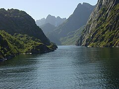 Trollfjord
 Raftsundet (strait) between Austvågøy and Hinnøya, painting by Eckenbrecher
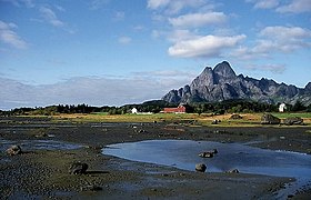 Vågakallen, at 942 metres in height


See also
References
- Thorsnæs, Geir, ed. (9 April 2017). "Austvågøya". Great Norwegian Encyclopedia (in Norwegian). Kunnskapsforlaget. Retrieved 18 December 2018.
External links
- DNT - Trollfjordhytta - DNT lodge near Trollfjord
На других языках
[de] Austvågøya
Austvågøya ist zugleich die größte und östlichste Insel der Lofotenkette. Sie teilt sich in zwei Kommunen. Der nordöstliche Teil wird von der in der Region Vesterålen befindlichen Kommune Hadsel verwaltet, während der westliche und größere Teil die Kommune Vågan bildet.- [en] Austvågøy
[es] Austvågøy
Austvågøy (también conocida como Austvågøya) es una isla de Noruega, la más al nordeste de las islas más grandes del archipiélago de Lofoten, perteneciente al condado de Nordland. La isla ocupa una superficie de 526.7 km² y se extiende más de 40 km en dirección este-oeste y 30 km norte-sur. Austvågøy es fundamentalmente un macizo montañoso. El monte más alto de Lofoten es Higravstind (1145 m), localizado en la parte oriental de la isla. Svartsundtindan (1050 m), Trolltindan (1045 m) y Olsanestind (1000 m) también están en esta parte oriental, mientras que el famoso Vågakallen (942 m) se encuentra al sur.[fr] Austvågøya
Austvågøya (en norvégien : « l'île d'Austvåg ») est une île de l'archipel des Lofoten, en Norvège.[it] Austvågøy
Austvågøy è un'isola appartenente all'arcipelago delle Lofoten, in Norvegia.[ru] Эуствогёй
Э́уствогёй[1][2], или Эствогё[3] (норв. Austvågøy), — крупнейший северо-восточный остров в архипелаге Лофотен, расположенный в фюльке Нурланн в Норвегии. Площадь острова составляет 526,7 км², он простирается на 40 км с востока на запад и на 30 км с севера на юг. Остров является горным массивом, с низменностями возле побережья. Самая высокая гора острова — Хигравстинден (норв. Higravstinden), 1146 м, расположена в восточной части острова. Также в восточной части расположены горы Svartsundtindan (1050 м), Trolltindan (1045 м) и Olsanestind (1000 м), однако известнейшая гора Вогакаллен (норв. Vågakallen, 942 м), возвышается в юго-западной части острова.Другой контент может иметь иную лицензию. Перед использованием материалов сайта WikiSort.org внимательно изучите правила лицензирования конкретных элементов наполнения сайта.
WikiSort.org - проект по пересортировке и дополнению контента Википедии