geo.wikisort.org - Insel
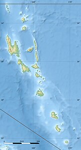
Die Torres-Inseln sind die nördlichste Inselgruppe des südpazifischen Inselstaats Vanuatu. Zusammen mit den Banks-Inseln bilden sie die vanuatuische Provinz Torba.
| Torres-Inseln | ||
|---|---|---|
 | ||
| Gewässer | Korallenmeer | |
| Geographische Lage | 13° 15′ S, 166° 37′ O | |
|
| ||
| Anzahl der Inseln | 7 | |
| Hauptinsel | Hiw | |
| Gesamte Landfläche | 117,7 km² | |
| Einwohner | 826 (2009) | |
 | ||
Geographie
Die kleine Gruppe grenzt im Norden an die Salomon-Inseln und im Südosten an die Banks-Inseln. Westlich der Torres-Inseln befindet sich, an der tektonischen Schnittstelle von australischer und pazifischer Platte, ein tiefer Meeresgraben (Torres-Graben).
Die Inseln erstrecken sich über etwa 44 km Luftlinie und sind, im Gegensatz zu nahezu allen anderen Inseln von Vanuatu, keine Vulkan-, sondern Koralleninseln. Die höchsten geographischen Punkte liegen maximal 200 m über Meereshöhe. Zur Gruppe zählen folgende Inseln:
| Inselname | Fläche (km²) |
Bevölkerung 2009 |
Hauptort | Gipfel | Höhe (Meter) |
Geokoordinate |
|---|---|---|---|---|---|---|
| Hiw | 50,6 | 269 | Gavigamana | Mount Wonvara | 366 | 13° 8′ S, 166° 34′ O |
| Metoma | 3,0 | 13 | Rival | ... | 115 | 13° 12′ S, 166° 36′ O |
| Tegua | 30,7 | 58 | Lateu | Tawaten | 300 | 13° 15′ S, 166° 37′ O |
| Ngwel | 0,07 | - | - | ... | 4 | 13° 16′ S, 166° 35′ O |
| Linua | 2,2 | - | - | ... | 26 | 13° 20′ S, 166° 38′ O |
| Loh | 11,9 | 210 | Lungharegi | ... | 115 | 13° 21′ S, 166° 39′ O |
| Toga | 18,8 | 276 | Litew | Mount Lemeura | 240 | 13° 25′ S, 166° 42′ O |
| Torres-Inseln | 117,2 | 826 | Lungharegi | Mount Wonvara | 366 | 13° 15′ S, 166° 37′ O |
Name der Inselgruppe
Die Bezeichnung Torres-Inseln leitet sich vermutlich vom Namen des portugiesischen Nautikers Luiz Vaéz de Torres ab, der im 16. Jahrhundert gemeinsam mit dem Seefahrer Pedro Fernández de Quirós auch einige Inseln des heutigen Vanuatu aufsuchte. Nach Luiz Vaéz de Torres sind aber insbesondere die "Torres-Straße", eine Meerenge zwischen Australien und Neuguinea, sowie die dort gelegenen Torres Strait Inseln benannt. Die Inseln vor der australischen Nordküste haben allerdings mit den hier beschriebenen vanuatuischen, und über 1700 km östlicher gelegenen, Torres-Inseln nichts zu tun.
Bevölkerung

Auf den Torres-Inseln leben heute 826 Menschen,[1] die zwei Sprachen sprechen: Hiw und Lo-Toga.[2] Die Siedlung Lungharegi an der Nordküste der Insel Loh gilt als offizielle Verwaltungsstelle der Inselgruppe, die eine der sieben Gemeinden der Provinz Torba bildet.
Literatur
- Walter John Durrad: Notes on the Torres Islands. In: Oceania, Band 10, Nr. 4, Juni 1940, S. 389–403
- Walter John Durrad: Notes on the Torres Islands (Continued). In: Oceania, Band 11, Nr. 1, September 1940, S. 75–109
- Walter John Durrad: Notes on the Torres Islands (Continued). In: Oceania, Band 11, Nr. 2, Dezember 1940, S. 186–201
Weblinks
Einzelnachweise
На других языках
- [de] Torres-Inseln (Vanuatu)
[en] Torres Islands
The Torres Islands are in the Torba Province of the country of Vanuatu, and is that country’s the northernmost island group. The chain of islands that make up this micro-archipelago straddles the broader cultural boundary between Island Melanesia and several Polynesian outliers located in the neighbouring Solomon Islands. To the island chain’s north is Temotu Province of the Solomon Islands, to its south is Espiritu Santo, and to its southeast are the Banks Islands. To the west, beneath the ocean surface, is the deep Torres Trench, which is the subduction zone between the Australian and Pacific plates.[es] Islas Torres
Las islas Torres son un grupo de pequeñas islas situadas en la parte septentrional del archipiélago de las islas Vanuatu. Administrativamente pertenecen, junto con las islas Banks, a la provincia de Torba de la República de Vanuatu.[fr] Îles Torrès
Les îles Torres ou Torrès[1] sont un archipel du Vanuatu situé au nord-ouest des îles Banks avec lesquelles elles forment la province administrative de Torba. C’est l’archipel le plus septentrional du pays, proche de la frontière maritime avec les îles Salomon. Elles sont peuplées par 826 habitants[2].[it] Isole Torres
Le Isole Torres sono un gruppo di isole di origine vulcanica dell'Oceano Pacifico, le più settentrionali di Vanuatu collocate nella Provincia di Torba.[ru] Острова Торрес
Острова Торрес (англ. Torres Islands) — группа островов в юго-западной части Тихого океана между островами Санта-Крус и Новые Гебриды. Входят в состав провинции Торба Республики Вануату. Административным центром островов является поселение Лунгхареги (Lungharegi).Другой контент может иметь иную лицензию. Перед использованием материалов сайта WikiSort.org внимательно изучите правила лицензирования конкретных элементов наполнения сайта.
WikiSort.org - проект по пересортировке и дополнению контента Википедии
