geo.wikisort.org - Insel
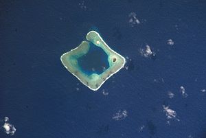
Das Rose-Atoll, auch Rose Island, ist ein unbewohntes[1], nahezu quadratisch geformtes Atoll im Pazifischen Ozean, das zum Territorium Amerikanisch-Samoas gehört. Die Landfläche beträgt 0,214 km², und die Gesamtfläche des Atolls mit Lagune beträgt rund 5 km². Im Nordosten des Korallenriffs liegen zwei Inseln, die größere Rose Island im Osten und die vegetationslose Sand Island im Norden.
| Rose-Atoll | ||
|---|---|---|
 | ||
| Gewässer | Pazifischer Ozean | |
| Archipel | Samoa-Inseln | |
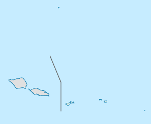
| Geographische Lage | 14° 33′ S, 168° 9′ W | |
|
| ||
| Anzahl der Inseln | 2 | |
| Hauptinsel | Rose Island | |
| Landfläche | 21,4 ha | |
| Lagunenfläche | 2,46 km² | |
| Gesamtfläche | 6,6 km² | |
| Einwohner | unbewohnt | |
 | ||
Das Rose-Atoll bildet das am weitesten südlich gelegene Territorium der USA.
Die erste dokumentierte Sichtung eines Europäers erfolgte durch Louis de Freycinet im Jahr 1819, der das Atoll nach seiner Frau Rose de Freycinet Île de Rose nannte. 1824 wurde das Atoll von einer Expedition unter Otto von Kotzebue, der es nach seinem ersten Leutnant Kordinkow benannte, erneut gesichtet.
Die zwei Inselchen bilden als bedeutender Vogelrastplatz und Brutplatz der Grünen Meeresschildkröte seit 1973 das Rose Atoll National Wildlife Refuge[2]. 2009 wurde zudem das Rose Atoll Marine National Monument ausgewiesen. Die Betreuung der beiden Schutzgebiete liegt beim U.S. Fish and Wildlife Service und der Regierung von Amerikanisch-Samoa.
Mögliche Flächenreduzierung vom Rose Atoll Marine National Monument durch Präsident Trump
Am 26. April 2017 hatte Präsident Trump mit Executive Order 13792 das Innenministerium der Vereinigten Staaten angewiesen die Flächengröße von 27 National Monuments, welche nach dem 1. Januar 1996 ausgewiesen wurden und mindestens 100.000 Hektar Flächengröße haben, zu überprüfen.[3] Am 24. August legte Innenminister Ryan Zinke den Abschlussbericht zur Executive Order 13792 vor. Der Abschlussbericht forderte die Flächenreduzierung vom Bears Ears National Monument, Cascade-Siskiyou National Monument, Gold Butte National Monument, Grand Staircase-Escalante National Monument, Pacific Remote Islands Marine National Monument und Rose Atoll Marine National Monument. Ferner sollen bei allen geprüften National Monuments mehr traditionelle menschliche Nutzungen wie Beweidung, Holzeinschlag, Kohleabbau und kommerzielle Fischerei innerhalb der Schutzgebiete zugelassen werden. Zinke begründete dies damit, dass Präsidenten in den letzten Jahrzehnten zu weit gegangen seien, um kommerzielle Aktivitäten in den National Monuments einzuschränken.[4][5] Eine Flächenreduzierung des Rose Atoll Marine National Monuments wurde durch Präsident Trump, anders als bei anderen Monumenten, nicht durchgeführt.
 Luftaufnahme von Rose Island
 Hinweistafel des USFWS
- President Bush bei Ausweisung des Rose Atoll Marine National Monument am 6. Januar 2009
Einzelnachweise
- United States Census Bureau
- U.S. Fish and Wildlife Service
- Executive Order 13792 of April 26, 2017 Review of Designations Under the Antiquities Act
- Final Report Summarizing Findings of the Review of Designations Under the Antiquities Act
- Shrink at least 4 national monuments and modify a half-dozen others, Zinke tells TrumpWashington Post vom 17. September 2017
На других языках
- [de] Rose-Atoll
[en] Rose Atoll
Rose Atoll, sometimes called Rose Island or Motu O Manu ("Bird Island") by people of the nearby Manu'a Islands, is an oceanic atoll within the U.S. territory of American Samoa. An uninhabited wildlife refuge, it is the southernmost point belonging to the United States. The land area is just 0.05 km2 (12 acres) at high tide. The total area of the atoll, including lagoon and reef flat amounts to 6.33 km2 (1,560 acres). Just west of the northernmost point is a channel into the lagoon, about 40 m wide. There are two islets on the northeastern rim of the reef, larger Rose Island in the east (3.5 m high) and the non-vegetated Sand Island in the north (1.5 m high). The Rose Atoll Marine National Monument that lies on the two outstanding islands of the Atoll is managed cooperatively between the U.S. Fish and Wildlife Service and the government of American Samoa.[1][fr] Rose (île)
L'île Rose est un atoll des Samoa américaines, point situé le plus au sud des États-Unis.[it] Atollo Rose
L'atollo Rose (in inglese Rose Atoll, in samoano Motu O Manu) è un atollo delle Samoa Americane, situato a est delle isole Manu'a.[ru] Розе (атолл)
Атолл Розе (англ. Rose Atoll, иногда остров Розе, остров Роз) — необитаемый[1] атолл, заповедник недалеко от островов Мануа. Является частью Американского Самоа. Древнее название — Моту-О-Ману (Motu O Manu).Другой контент может иметь иную лицензию. Перед использованием материалов сайта WikiSort.org внимательно изучите правила лицензирования конкретных элементов наполнения сайта.
WikiSort.org - проект по пересортировке и дополнению контента Википедии


