geo.wikisort.org - Island
The Treshnish Isles are an archipelago of small islands and skerries, lying west of the Isle of Mull, in Scotland. They are part of the Inner Hebrides. Trips to the Treshnish Isles operate from Ulva Ferry, Tobermory, Ardnamurchan and Tiree
| Scottish Gaelic name | Eileanan Treisinis |
|---|---|
| Meaning of name | unknown |
| Location | |
 Treshnish Isles Treshnish Isles shown within Argyll and Bute | |
| OS grid reference | NM278419 |
| Coordinates | 56.49°N 6.42°W |
| Physical geography | |
| Island group | Mull |
| Area | 128 ha (316 acres)[1] |
| Highest elevation | Cruachan, on Lunga 103 m (338 ft) |
| Administration | |
| Sovereign state | United Kingdom |
| Country | Scotland |
| Council area | Argyll and Bute |
| Demographics | |
| Population | 0 |
| References | [2] |
Geography
The archipelago extends over a distance of roughly 7 kilometres (4 mi), from the island of Bac Beag in the south (towards Cairn na Burgh Beag) to the north-east. The largest island in the group, Lunga, is 7 kilometres (4 mi) west of Gometra, 6 kilometres (4 mi) south-west of Rubha' a' Chaoil (on the Isle of Mull), 12 kilometres (7 mi) south-east of Coll, and 5 kilometres (3 mi) north-west of Staffa.[2]
Other relatively large islands in the group are Cairn na Burgh Mòr, Fladda and Bac Mòr. There are numerous small skerries, particularly north of Lunga. All the islands are of volcanic origin.[3]
| Island | Gaelic name[4] | Area (ha)[4] | Highest point (m)[5] |
|---|---|---|---|
| Bac Beag | Am Baca Beag | 6.7 | 27 |
| Bac Mòr | Am Baca Mòr | 24.7 | 86 |
| Lunga | Lunga | 59.9 | 103 |
| Sgeir a' Chaisteil | Sgeir a' Chaisteil | 3.7 | 26 |
| Sgeir an Eirionnaich | Sgeir an Eirionnaich | 5 | 15 |
| Fladda | Flada | 20.6 | 26 |
| Cairn na Burgh Mòr | Cairn Bhuirg Mòr | 3.6 | 35 |
| Cairn na Burgh Beag | Cairn Bhuirg Beag | 2.2 | 22 |
History
There are several possible duns on the islands of Iron Age origin. Little is known of the early history, although these prominent landmarks would have been significant waypoints for the Norse settlers during their conquest in the early years of the Kingdom of the Isles,[4] which lasted from the 9th to the 13th centuries. There are remains on Lunga of a village of blackhouses abandoned in 1857[6]
The Isles were purchased in 1938 by explorer and naturalist Col. Niall Rankin and they were sold to the Hebridean Trust in 2000.[7] The Trust are guardians of the islands to protect them and the wildlife and to monitor and study the ecology and archaeology.[8]
Due to the beauty and remoteness of the Isles and the abundance of wildlife, particularly the puffins, they are very popular with tourists who visit by boat, generally to Lunga, for day-trips during the summer.
Etymology
Treisinis is a Gaelic name of unknown meaning that includes the Old Norse root ness, meaning 'headland'.[9]
Bac Mòr is also known as "The Dutchman's Cap" in English due to its shape. Bac Beag is from the Gaelic Am Baca Beag, with Bac meaning 'bank' or 'dune' and Beag simply being a diminutive in contrast to Mòr. Bac Mòr is also known as Baca Rois in Gaelic, which means 'dune of the Ross' and is a reference to the shape of the island when framed against the Ross of Mull. Lunga is probably from the Old Norse lungr-øy, meaning 'longship island'.[4][10] Sgeir an Eirionnaich and Sgeir a' Chaisteil are Gaelic names meaning 'Irishman's skerry' and 'castle skerry' respectively. Cairn na Burgh Mòr means 'cairn of the large fort' and Cairn na Burgh Beg is thus 'cairn of the small fort'.[4]
The name Fladda originates from the Old Norse for 'flat island'.[11]
Natural history and conservation
The Treshnish Isles are part of the Loch na Keal National Scenic Area, one of 40 in Scotland.[12] They are also designated as a Site of Special Scientific Interest, a Special Protection Area[13] due to their importance for breeding seabirds and a marine Special Area of Conservation.[14] They are also known for their Atlantic grey seals and ruined castles.[15]
 |
 |
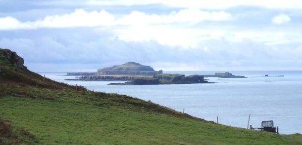
| The Treshnish Isles from above Port Haunn on Mull. Nearest are Cairn na Burgh Beag and Cairn na Burgh Mòr. Behind are the low flat island of Fladda and the tallest island, Lunga, which obscures Bac Mòr and Bac Beag beyond. | The Treshnish Isles from the east as seen from Loch Tuath. From left to right: (Ellean Dioghlum), Bac Mòr, Lunga, Fladda, Cairn na Burgh Mòr, Cairn na Burgh Beag. |
See also
Notes
- Treshnish Isles Management Plan p. 3
- Ordnance Survey Landranger Map (1:50 000) "Iona & West Mull". Sheet 48
- Haswell-Smith (2004) p. 106
- Treshnish Isles Management Plan p. 5
- Ordnance Survey Explorer Map (1:25 000) "Isle of Mull North & Tobermory". Sheet 374.
- The Scottish Islands - Haswell-Smith (2008) p.108
- The Scottish Islands - Haswell-Smith (2008) p.106
- Hebridean Trust website
- Mac an Tailleir (2003) p. 114
- Haswell-Smith (2004) p. 105
- Mac an Tailleir (2003) p. 50
- "National Scenic Areas". Scottish Natural Heritage. Archived from the original on 11 March 2017. Retrieved 30 March 2011.
- "SPA description: Treshnish". Joint Nature Conservation Committee. Retrieved 28 July 2007.
- "Argyll Marine SAC: Treshnish Isles". Retrieved 28 July 2007.
- "Mull and Iona". Scotland View. Retrieved 28 July 2007.
References
- Haswell-Smith, Hamish (2004). The Scottish Islands. Edinburgh: Canongate. ISBN 978-1-84195-454-7.
- Mac an Tailleir, Iain (2003) "Ainmean-àite le buidheachas/Placenames". Scottish Parliament/Pàrlamaid na h-Alba. (pdf) Retrieved 12 May 2012.
- Treshnish Isles Management Plan 2001-11 (2001) The Hebridean Trust.
External links
| Main settlements |  | |
|---|---|---|
| Smaller settlements | ||
| Geographical features |
| |
| History and architecture |
| |
| Local culture and economy |
| |
| Surrounding islands | ||
Inhabited islands of the Hebrides | ||
|---|---|---|
| Inner Hebrides |  | |
| Outer Hebrides |
| |
|  | ||||||||||||||||
|
| |||||||||||||||||
| |||||||||||||||||
| |||||||||||||||||
| |||||||||||||||||
| |||||||||||||||||
| |||||||||||||||||
| |||||||||||||||||
| Authority control: National libraries |
|---|
На других языках
[de] Treshnish Isles
Die Treshnish Isles sind eine unbewohnte Inselgruppe, die zu den Inneren Hebriden in Schottland gehört.- [en] Treshnish Isles
[es] Islas Treshnish
Las Islas Treshnish forman un archipiélago de pequeñas islas e islotes en Escocia, concretamente al oeste de la isla de Mull, en el Area Council de Argyll y Bute. Son pues, parte de las Hébridas Interiores. De norte a sur, las islas más grandes incluyen:[fr] Îles Treshnish
Les îles Treshnish sont un groupe d'îles appartenant à l'archipel des Hébrides intérieures en Écosse. Ces îles sont situées à cinq kilomètres à l'ouest de Mull, dans la mer des Hébrides, et font partie du Council area d'Argyll and Bute.Другой контент может иметь иную лицензию. Перед использованием материалов сайта WikiSort.org внимательно изучите правила лицензирования конкретных элементов наполнения сайта.
WikiSort.org - проект по пересортировке и дополнению контента Википедии