geo.wikisort.org - Sea
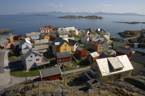
Po Toi O (Chinese: 布袋澳; lit. 'Cloth Pouch Bay')[1] is a small fishing village[2] at Clear Water Bay Peninsula, Sai Kung, New Territories, Hong Kong.


The village is situated at a bay shaped like a sack, thus earning its name Po Toi (meaning a "sack").
Administration
Po Toi O is a recognized village under the New Territories Small House Policy.[3]
History
Po Toi O was historically a multi-clan village with surnames Cheung (張), Chan (陳), Chong (莊) and others.[4]
Features
This small fishing village has two seafood restaurants and is popular with tourists.
There is a Hung Shing Temple in Po Toi O. The temple was probably built in 1663. A Kung So (公所) building adjacent to the temple was built in 1740 and was used to deal with village affairs and served as a school until the 1930s.[5] The temple is a Grade III historic building.
In popular culture
- Parts of the Hollywood movie Lara Croft: Tomb Raider – The Cradle of Life were filmed here.
- Australian celebrity chef Kylie Kwong visited Po Toi O for an episode of the TV series Kylie Kwong: Simply Magic. The episode was called "Hong Kong Island Hideaway".
- In the 2018 ITV TV miniseries Strangers, an apartment owned by a murder victim in Po Toi O proves important to the plot.
Transportation
Po Toi O can be reached by land using Po Toi O Chuen Road (布袋澳村路). The village is served by green minibus 16 - Po Lam, Tseung Kwan O to Po Toi O.[6][2]
References
- Film Services Office: Po Toi O Village
- Agriculture, Fisheries and Conservation Department: Clearwater Bay Country Park
- "List of Recognized Villages under the New Territories Small House Policy" (PDF). Lands Department. September 2009.
- Antiquities Advisory Board. Historic Building Appraisal. Hung Shing Temple , Po Toi O
- Brief Information on Proposed Grade III Items. Item #1054 Archived 2017-03-11 at the Wayback Machine
- Transport Department website: Green Minibus Route 16
External links
- Delineation of area of existing village Po Toi O (Hang Hau) for election of resident representative (2019 to 2022)
- Pictures of Po Toi O
| |||||||||||||
| |||||||||||||

Другой контент может иметь иную лицензию. Перед использованием материалов сайта WikiSort.org внимательно изучите правила лицензирования конкретных элементов наполнения сайта.
WikiSort.org - проект по пересортировке и дополнению контента Википедии