geo.wikisort.org - Sea
Liaodong Bay (simplified Chinese: 辽东湾; traditional Chinese: 遼東灣; pinyin: Liáodōng Wān) is largest and longest of the three main bays (along with Laizhou Bay to the south and the Bohai Bay to the southwest) of the Bohai Sea, the innermost gulf of the Yellow Sea.

This article does not cite any sources. (December 2009) |
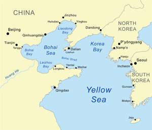
Although named after the Liaodong Peninsula (which forms its eastern shore), the bay is located directly south of the Liaoxi region, almost entirely west of the Liao River. It is bounded by the coastline of cities from southern Liaoning province (Dalian, Yingkou, Panjin, Jinzhou and Huludao) and eastern Hebei province (Qinhuangdao and Tangshan), between the Laotieshan Cape at Dalian's Lüshunkou District in the east, and the Daqing River estuary (which is an old southern mouth of Luan River) at Tangshan's Laoting County in the west.
The major rivers that drain into the Liaodong Bay include Luan River, Daling River, Xiaoling River, Liao River and Daliao River.
See also
- Geography of China
- Bijia Mountain - an island-mountain in the bay
Authority control | |
|---|---|
| General | |
| National libraries | |
This Chinese location article is a stub. You can help Wikipedia by expanding it. |
На других языках
- [en] Liaodong Bay
[ru] Ляодунский залив
Ляоду́нский зали́в — внутренний залив Жёлтого моря, расположен в Китае.Другой контент может иметь иную лицензию. Перед использованием материалов сайта WikiSort.org внимательно изучите правила лицензирования конкретных элементов наполнения сайта.
WikiSort.org - проект по пересортировке и дополнению контента Википедии