geo.wikisort.org - Sea
The Florida Current is a thermal ocean current that flows from the Straits of Florida around the Florida Peninsula and along the southeastern coast of the United States before joining the Gulf Stream Current near Cape Hatteras. Its contributing currents are the Loop Current and the Antilles Current. The current was discovered by Spanish explorer Juan Ponce de León in 1513.
This article includes a list of references, related reading or external links, but its sources remain unclear because it lacks inline citations. (September 2017) |
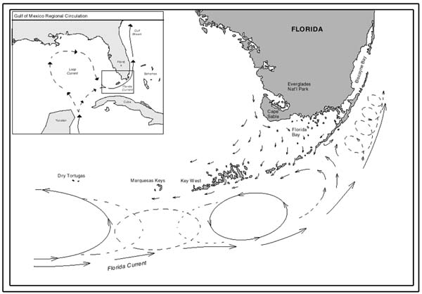
The Florida Current results from the movement of water pushed from the Atlantic into the Caribbean Sea by the rotation of the Earth (which exerts a greater force at the equator). The water piles up along Central America and flows northward through the Yucatán Channel into the Gulf of Mexico. The water is heated in the Gulf and forced out through the Florida Straits, between the Florida Keys and Cuba and flows northward along the east coast of the United States. The Florida Current is often referred to imprecisely as the Gulf Stream. In fact, the Florida Current joins the Gulf Stream off the east coast of Florida.
Transport
The Florida Current has an estimated mean transport of 30 Sv,[1][2][3] varying seasonally and interannually by as much as 10 Sv.[3] The volume transport increases as it flows farther north, reaching its maximum transport of 85 Sv near Cape Hatteras.[4]
The water reaches a velocity of 1.8 m/s or 3.6 knots.
Seasonal variation
The Florida current reaches a maximum transport in July and a minimum transport in October, with a subsequent secondary maximum and minimum occurring in January and April, respectively.[5] Shorter variations in the transport may last between 2 and 20 days depending on wind current patterns, and are shortest during the summer months.[6]
Spatial scale
Like transport, the spatial magnitude of the current increases along its course. At 27°N, it has a width of 80 km (50 mi); it gradually increases from 120 km (75 mi) at 29°N to 145 km (90 mi) where it flows into the Gulf Stream at 73°W.[7]
See also
- Ocean current
- Oceanic gyre
- Physical oceanography
References
- Schmitz, William J. (1968-12-01). "On the transport of the Florida current". Deep Sea Research and Oceanographic Abstracts. 15 (6): 679–693. Bibcode:1968DSROA..15..679S. doi:10.1016/0011-7471(68)90081-8.
- Leaman, Kevin D.; Molinari, Robert L.; Vertes, Peter S. (1987-05-01). "Structure and Variability of the Florida Current at 27°N: April 1982–July 1984". Journal of Physical Oceanography. 17 (5): 565–583. Bibcode:1987JPO....17..565L. doi:10.1175/1520-0485(1987)017<0565:SAVOTF>2.0.CO;2. ISSN 0022-3670.
- Schott, Friedrich A.; Lee, Thomas N.; Zantopp, Rainer (1988-09-01). "Variability of Structure and Transport of the Florida Current in the Period Range of Days to Seasonal". Journal of Physical Oceanography. 18 (9): 1209–1230. Bibcode:1988JPO....18.1209S. doi:10.1175/1520-0485(1988)018<1209:VOSATO>2.0.CO;2. ISSN 0022-3670.
- Worthington; Kawai (1972). "Comparisons between deep sections across the Kuroshio and the Florida Current and Gulf Stream". In Stommel; Yoshida (eds.). Kuroshio, its Physical Aspects. Tokyo: University of Tokyo Press. pp. 371–385.
- Montgomery, R (1938). "Fluctuations in the monthly sea level on the eastern U.S. Coast as related to dynamics of the western North Atlantic Ocean". Journal of Marine Research. 1: 32–37.
- Lee, T; Williams, E (1988). "Wind-forced transport fluctuations of the Florida Current". Journal of Physical Oceanography. 18: 937–946. doi:10.1175/1520-0485(1988)018<0937:wftfot>2.0.co;2.
- Leaman, K; Johns, E; Rossby, T (1989). "The average distribution of volume transport and Potential Vorticity with temperature at three sections across the Gulf Stream". Journal of Physical Oceanography. 19 (1): 36–51. Bibcode:1989JPO....19...36L. doi:10.1175/1520-0485(1989)019<0036:TADOVT>2.0.CO;2.
External links
- Florida Current Transport Time Series and Cruises; Western Boundary Time Series
- Joanna Gyory et al. The Florida Current; University of Miami
Ocean currents and gyres | |||||||||||
|---|---|---|---|---|---|---|---|---|---|---|---|
| Currents |
| ||||||||||
| Gyres |
| ||||||||||
| Related |
| ||||||||||
На других языках
- [en] Florida Current
[ru] Флоридское течение
Флоридское течение — тёплое морское течение в Атлантическом океане вдоль юго-восточного побережья американского штата Флорида.Другой контент может иметь иную лицензию. Перед использованием материалов сайта WikiSort.org внимательно изучите правила лицензирования конкретных элементов наполнения сайта.
WikiSort.org - проект по пересортировке и дополнению контента Википедии