geo.wikisort.org - Sea
Chatham Harbour (former name States Bay, Spanish: Puerto de San Joseph, Puerto de San José) is the large bay indenting the central part of Weddell Island in the Falkland Islands.[1] It is entered east of Beacon Point and west of Loop Head. The 3 km wide bay extends 5 km in southeast direction, this part of the feature forming an anchorage named Bald Road, and north of Clay Point turning for 10 km in southwest direction. Chatham Harbour is centred at 51°50′16″S 60°57′32″W.


States Cove (former names States Harbour, Hussey Harbour) is an estuary on the southeast side of Chatham Harbour, centred at 51°50′15″S 60°54′15″W.[2]
Maps
- The Falkland Islands. Scale 1:401280 map. London: Edward Stanford, 1901
- Falkland Islands Explorer Map. Scale 1:365000. Ocean Explorer Maps, 2007
- Falklands Topographic Map Series. Scale 1:50000, 29 sheets. DOS 453, 1961-1979
- Falkland Islands. Scale 1:643000 Map. DOS 906. Edition 3-OS, 1998
- Map 500k--xm20-4. 1:500000 map of Weddell Island and part of West Falkland. Russian Army Maps (for the world)
- Approaches to the Falkland Islands. Scale 1:1500000 chart. Gps Nautical Charts, 2010
- Illustrated Map of Weddell Island
Gallery
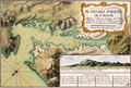 A post 1770 large scale, southeast-up map of Chatham Harbour (Puerto de San Joseph in the title); the illustration shows a north view of the harbour entrance marked by Bald Island (island “A”), with Mount Weddell prominent in the background
 States Bay, States Harbour and Swan Island (present Chatham Harbour, States Cove and Weddell Island) on a pre 1829 Falklands map by Charles Barnard
 1841 Falkland Islands map by John Arrowsmith, fragment featuring Swan Island, States Harbour and Great Harbour (present Weddell Island, States Cove and Gull Harbour)
 Map of Weddell Island


Notes
- Chatham Harbour. Falkland Islands. GeoNames Geographical Database
- States Cove. Falkland Islands. GeoNames Geographical Database
References
- B. Stonehouse (ed.). Encyclopedia of Antarctica and the Southern Oceans. Chichester, West Sussex: John Wiley & Sons, 2002. 404 pp. ISBN 978-0-471-98665-2
- C.H. Barnard. A Narrative of the Sufferings and Adventures of Capt. Charles H. Barnard, in a Recent Voyage Round the World, Including an Account of His Residence for Two Years on An Uninhabited Island. New York: J.P. Callender, 1836
- P.P. King and R. Fitzroy. The South America Pilot. Part II. From the Rio de la Plata to the Bay of Panama, including Magellan Strait, the Falkland, and Galapagos Islands. Fifth Edition. London: Printed for the Hydrographic Office, Admiralty, 1860. pp. 116–118
External links
- Weddell Island Official Website
- Weddell Island from space. NASA Johnson Space Center, 30 April 2005
Capital: Port Stanley | |||||||
| History |
| ||||||
| Geography | |||||||
| Military |
| ||||||
| Politics |
| ||||||
| Economy |
| ||||||
| Society |
| ||||||
(*) Sixth-formers attend Peter Symonds College in England and national diploma/NVQ students attend Chichester College in England | |||||||
Текст в блоке "Читать" взят с сайта "Википедия" и доступен по лицензии Creative Commons Attribution-ShareAlike; в отдельных случаях могут действовать дополнительные условия.
Другой контент может иметь иную лицензию. Перед использованием материалов сайта WikiSort.org внимательно изучите правила лицензирования конкретных элементов наполнения сайта.
Другой контент может иметь иную лицензию. Перед использованием материалов сайта WikiSort.org внимательно изучите правила лицензирования конкретных элементов наполнения сайта.
2019-2025
WikiSort.org - проект по пересортировке и дополнению контента Википедии
WikiSort.org - проект по пересортировке и дополнению контента Википедии