geo.wikisort.org - River
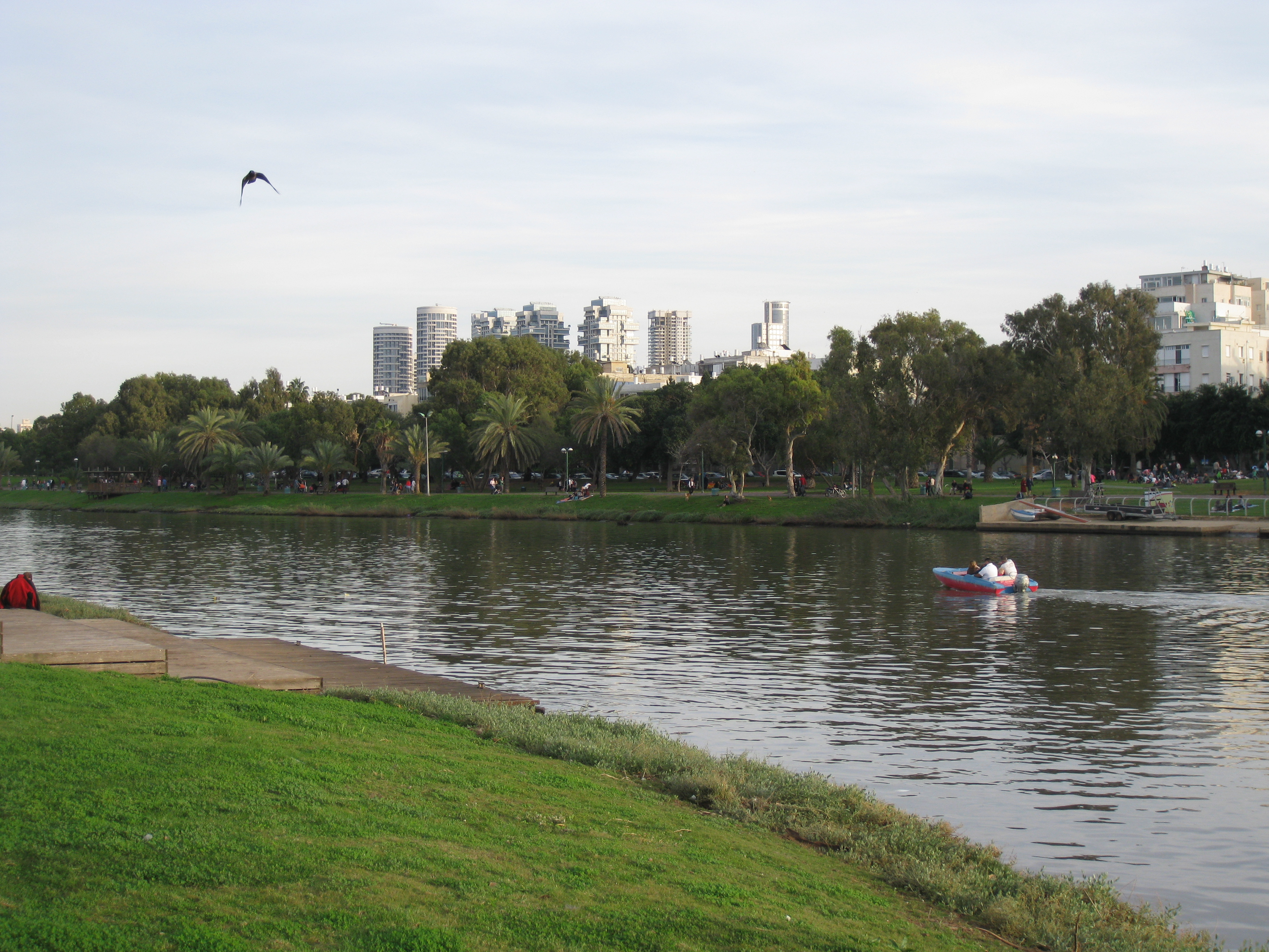
The Yarkon River, also Yarqon River or Jarkon River[1] (Hebrew: נחל הירקון, Nahal HaYarkon, Arabic: نهر العوجا, Nahr al-Auja), is a river in central Israel. The source of the Yarkon ("Greenish" in Hebrew) is at Tel Afek (Antipatris), north of Petah Tikva. It flows west through Gush Dan and Tel Aviv's Yarkon Park into the Mediterranean Sea. Its Arabic name, al-Auja, means "the meandering". The Yarkon is the largest coastal river in Israel, at 27.5 km in length.[2]
| Yarkon River | |
|---|---|
 | |
| Location | |
| Country | Israel |
| Cities | Tel Aviv, Petah Tikva, Rosh HaAyin |
| Physical characteristics | |
| Source | Tel Afek |
| • location | near Rosh Ha'ayin, Central District, Israel |
| Mouth | Mediterranean Sea |
• location | Tel Aviv, Tel Aviv District, Israel |
• coordinates | 32°5′45″N 34°46′48″E |
| Length | 27.5 km (17.1 mi) |
History
Iron Age
The Yarkon was the northern boundary of the territory of the Philistines.[3] During the time of the Assyrian rule over the country, a fortress was built in a site known today as Tell Qudadi, on the northern bank of the river, next to its estuary.
Ottoman Period
The Yarkon formed the southern border of the vilayet of Beirut during the late Ottoman period.[2]
World War I
The Arabic name of the river, al-Auja ("the meandering one"), is shared with Wadi Auja, another small stream that flows into the Jordan Valley north of Jericho. During World War I this coincidence led to the term of "the line of the two Aujas" referring to a strategic line connecting the two river valleys and taken by the expeditionary forces of General Allenby during his early 1918 advance against the Ottoman army.[4]
The mouth of the river was conquered already during the late-1917 Battle of Jaffa.
Mandate period
In the Mandatory period, the British government granted a number of concessions, including to Pinhas Rutenberg's Jaffa Electric Company exclusive rights to generate, distribute, and sell electricity in the District of Jaffa. These rights were delivered through the “Auja Concession”, which was formally signed on September 12, 1921. The Concession had authorized the company to generate electricity by means of hydroelectric turbines that would exploit the water power of the Yarkon River to supply electricity to the administrative District of Jaffa. The district comprised Jaffa, the oldest and at the time still most important town in the area, the fast growing town of Tel Aviv north of it, and other smaller locations. Yet the plan to generate electricity by hydroelectric means never materialized, and instead the company designed and built a powerhouse that produced electricity by means of diesel-fueled engines.[5][page needed]

State of Israel
The river became increasingly polluted after the 1950s, many blaming this on the construction of the Reading Power Station which is situated near its mouth.
When the river's headwaters were diverted to the Negev via the National Water Carrier for irrigation purposes, the state of the Yarkon declined. As sewage replaced the flow of fresh water, habitats were destroyed and flora and fauna disappeared. This was exacerbated by continuous discharges of industrial effluents and municipal sewage into the rivers, which allowed algae to multiply.[6] On July 14, 1997, the infamous Maccabiah bridge collapse led to the death of four athletes, three of which died due to infections caused by exposure to the polluted river water.[7] Subsequent and ongoing cleanup projects, some government-run, some benefitting from financial aid from Jewish donors from Australia, and some with regional character supported by the NGO FoEME, helped improve the quality of the water.[8][9][10][11]
 Average Monthly Discharge (1969–1975)
 Average Annual Discharge (1969–1975)


Yarkon River Authority
In 1988, the Yarkon River Authority[12] was established to revitalize the river and make sections of it suitable for sailing, fishing, swimming and other recreation. Water quality improved after the construction of modern sewage treatment plants in Hod Hasharon and Ramat Hasharon. The river was dredged to restore its original depth and natural flow. River banks were raised and reinforced, hiking and bicycling paths were built, and picnic and fishing areas were developed with the help of contributions from the Australian Jewish community via the Jewish National Fund.[6]
Vegetation and Wildlife
The Yarkon River Authority website has a detailed list of vegetation[13] and wildlife[14] that can be found in and around the river. Mammals include: Nutria (coypu); Swamp cat; and Golden jackal. Although not mentioned by The Yarkon River Authority, mongoose has also been spotted by visitors and hikers.[15]
Maccabiah disaster
On July 14, 1997, four members of the Australian delegation to the Maccabiah Games were killed and 60 injured as a result of the collapse of a temporary pedestrian bridge over the Yarkon. The deaths were eventually traced to a fungal infection caused by aspiration of the heavily polluted water.[16]
See also
Further reading
- Eran Eldar, ‘The Yarkon is always green’: the ecological problems of the Yarkon River, Israel affairs, Volume 24, 2018 - Issue 5
References
- Beitzel, Barry J (2009). The New Moody Atlas of the Bible. Moody Publishers. ISBN 9780802404411.
- Weldon C. Matthews (2006) Confronting an Empire, Constructing a Nation: Arab Nationalists and Popular Politics in Mandate Palestine I.B.Tauris, ISBN 1-84511-173-7 p 26
- Fahlbusch, Erwin; Bromiley, Geoffrey William (2005). The Encyclopedia of Christianity, Volume 4: P-Sh. Grand Rapids, Michigan: Wm. B. Eerdmans Publishing. p. 185. ISBN 0-8028-2416-1.
- H. S. Gullett (1923). The Australian Imperial Force in Sinai and Palestine, 1914-1918. Sydney: Angus & Robertson Ltd. pp. 487, 542. Retrieved 16 September 2015.
Allenby did not hesitate. His original objective had been the "line of the two Aujas" from the Nahr Auja, which falls into the Mediterranean above Jaffa, to the Wady Auja, a little stream which, bursting from springs in the desert foot-hills above the Jordan valley, flows eastwards to the Jordan River about ten miles north of the Dead Sea.
- Shamir, Ronen (2013). Current Flow: The Electrification of Palestine. Stanford: Stanford University Press.
- A rural walk through the big cities, Jerusalem Post
- Trounson, Rebecca (August 9, 1997). "Bridge Collapse Casts Light on Israel's Troubled Waters" (Newspaper article). Los Angeles Times. Retrieved 26 March 2009.
- Keren Kayemeth LeIsrael–Jewish National Fund, The Wetland Project Revives Yarkon River, January 07, 2009
- EcoPeace Middle East (formerly Friends of the Earth Middle East), Good Water Neighbors - Cross Border Meetings throughout the Region, September 2015
- KKL-JNF staff,Cornerstone Laid for Bird-Watching Center in Yarkon Park, 26 December 2013
- WATEC Israel 2015 Conference, Yarkon River Rehabilitation Project
- https://en.yarkon-river.org.il/
- https://en.yarkon-river.org.il/ecology/vegetation/
- https://en.yarkon-river.org.il/ecology/animals/
- https://www.ramat-gan.muni.il/quality_environment/hiking_trails/hayarkon/
- Jewish Virtual Library Maccabiah Games
External links
- Yarkon River Authority (in Hebrew)
- Yarkon River Authority Archived 2014-05-15 at the Wayback Machine (in English)
- Nahr Abī Fuṭrus, Brill: Online Reference Works
Authority control | |
|---|---|
| General | |
| National libraries | |
| Other |
|
На других языках
[de] Yarkon
Der Yarkon (hebräisch .mw-parser-output .Hebr{font-size:115%}נַחַל הַיַּרְקוֹן .mw-parser-output .Latn{font-family:"Akzidenz Grotesk","Arial","Avant Garde Gothic","Calibri","Futura","Geneva","Gill Sans","Helvetica","Lucida Grande","Lucida Sans Unicode","Lucida Grande","Stone Sans","Tahoma","Trebuchet","Univers","Verdana"}Nachal ha-Jarqōn, deutsch ‚Fluss des Jarqon‘, auch Jarḳōn, in Luthers Schreibung Me-Jarkon, מֵי יַרְקוֹן Mej Jarqōn, Wässer des Grünlichen/Jarkon; Jos 19,46 LUT; arabisch العوجا, DMG Al-ʿŪǧā) ist ein 28 km langer, ganzjährig wasserführender Fluss in Israel, der bei Rosch haAjin entspringt und bei Tel Aviv ins Mittelmeer mündet. Er ist der wasserreichste aller Mittelmeer-Küstenflüsse Israels. „Yarkon“ bedeutet auf Hebräisch etwa „der Grünliche“. Sein arabischer Name lautet Al-ʿUja, was „der Mäandernde“ bedeutet.- [en] Yarkon River
[es] Río Yarkon
Río Yarkon (en hebreo: נחל הירקון, Nahal HaYarkon; también escrito Río Yarqon y en árabe:نهر العوجا, Nahr el-Auŷa), es un río en el centro del país asiático de Israel.[1] El origen del Yarkon ("verdoso" en hebreo) se encuentra en Tel Afek (Antipatris), al norte de Petah Tikva. Fluye al oeste a través de Gush Dan en el Mar Mediterráneo. El-Auja, la contraparte árabe, significa "serpenteo".[it] Yarkon
Il fiume Yarkon o Yarqon (in ebraico: נחל הירקון?, Nahal HaYarkon), è un corso fluviale del centro di Israele. Le sorgenti del fiume, in ebraico "verdastro" o "verdognolo" è a Tel Afek, a nord di Petah Tiqwa. Scorre ad ovest lungo il Gush Dan ed parco Yarkon di Tel Aviv fino al mar mediterraneo. Il suo nome arabo El-Auja, significa "sinuoso".[ru] Яркон
Ярко́н (ивр. נַחַל הַיַּרְקוֹן, араб. أبو بطرس Абу-Бутрус у истока, араб. العوجا эль-Ауджа в устье) — река в Израиле, протекающая в центральной части страны.Другой контент может иметь иную лицензию. Перед использованием материалов сайта WikiSort.org внимательно изучите правила лицензирования конкретных элементов наполнения сайта.
WikiSort.org - проект по пересортировке и дополнению контента Википедии