geo.wikisort.org - River
The West Branch is a 5.5-mile-long (8.9 km)[1] river located in eastern New Hampshire in the United States. It is the northern tributary of Ossipee Lake, part of the Saco River watershed leading to the Atlantic Ocean.
| West Branch | |
|---|---|
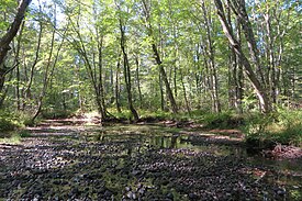
 The West Branch at summer low level north of Ossipee Lake | |
  | |
| Location | |
| Country | United States |
| State | New Hampshire |
| County | Carroll |
| Towns | Madison, Freedom, Ossipee |
| Physical characteristics | |
| Source | Silver Lake |
| • location | Madison |
| • coordinates | 43°50′55″N 71°10′17″W |
| • elevation | 468 ft (143 m) |
| Mouth | Ossipee Lake |
• location | Ossipee / Freedom |
• coordinates | 43°48′32″N 71°9′44″W |
• elevation | 407 ft (124 m) |
| Length | 5.5 mi (8.9 km) |
The West Branch begins at the outlet of Silver Lake in the southern corner of Madison, New Hampshire, and takes a winding course south towards Ossipee Lake. It forms the boundary between the towns of Freedom and Ossipee. The flat, sandy terrain through which the river flows is known as the West Branch Pine Barrens and is the site of a nature preserve owned and managed by The Nature Conservancy.
See also
References
External links
Текст в блоке "Читать" взят с сайта "Википедия" и доступен по лицензии Creative Commons Attribution-ShareAlike; в отдельных случаях могут действовать дополнительные условия.
Другой контент может иметь иную лицензию. Перед использованием материалов сайта WikiSort.org внимательно изучите правила лицензирования конкретных элементов наполнения сайта.
Другой контент может иметь иную лицензию. Перед использованием материалов сайта WikiSort.org внимательно изучите правила лицензирования конкретных элементов наполнения сайта.
2019-2025
WikiSort.org - проект по пересортировке и дополнению контента Википедии
WikiSort.org - проект по пересортировке и дополнению контента Википедии