geo.wikisort.org - River
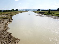
The Waipaoa River is a river of the northeast of New Zealand's North Island. It rises on the eastern slopes of the Raukumara Range, flowing south for 80 kilometres (50 mi) to reach Poverty Bay and the Pacific Ocean just south of Gisborne. For about half of this distance its valley is followed by State Highway 2. The river has several important tributaries, among them the Wharekopai, Waikohu, Mangatu, Waingaromia and Waihora rivers. Major settlements along the banks of the river include Te Karaka, Ormond, and Patutahi.
| Waipaoa River | |
|---|---|
 | |
| Location | |
| Country | New Zealand |
| Physical characteristics | |
| Source | Raukumara Range |
| Mouth | 38°42′48″S 177°56′31″E |
| Basin size | 2,150 km2 (830 sq mi) |
| Discharge | |
| • location | Poverty Bay |
References
На других языках
[de] Waipaoa River
Der Waipaoa River ist ein Fluss in der Region Gisborne auf der Nordinsel von Neuseeland.- [en] Waipaoa River
Текст в блоке "Читать" взят с сайта "Википедия" и доступен по лицензии Creative Commons Attribution-ShareAlike; в отдельных случаях могут действовать дополнительные условия.
Другой контент может иметь иную лицензию. Перед использованием материалов сайта WikiSort.org внимательно изучите правила лицензирования конкретных элементов наполнения сайта.
Другой контент может иметь иную лицензию. Перед использованием материалов сайта WikiSort.org внимательно изучите правила лицензирования конкретных элементов наполнения сайта.
2019-2025
WikiSort.org - проект по пересортировке и дополнению контента Википедии
WikiSort.org - проект по пересортировке и дополнению контента Википедии