geo.wikisort.org - River
The Wailoa River State Recreation Area, also known as Wailoa River State Park, is a park in Hilo, on Hawaiʻi Island in the US state of Hawaii. It was developed as a buffer zone following the devastating 1960 tsunami that wiped out the central bayfront district of Hilo.
| Wailoa River State Recreation Area | |
|---|---|
 Wailoa River State Recreation Area, including the Waiolama Footbridge across the mouth of Waiākea Pond | |
 Location of mouth | |
 | |
| Nearest city | Hilo, Hawaii |
| Coordinates | 19°43′7″N 155°4′30″W |
| Area | 131.9 acres (53.4 ha) |
| Created | 1969 |
| Operated by | State of Hawaiʻi |
| Website | dlnr |
Description

The name wai loa literally means "long water" in the Hawaiian language.[1] The Wailoa River itself flows just a short distance from Waiākea Pond within the park to the Pacific Ocean.[2]
- Points of interest
- Parks and open spaces
- Transportation
The park lies between downtown Hilo, Hawaii and Hilo Bay. The Hawaii Belt Road (Route 19, known as Kamehameha Avenue at this point) forms the northern boundary of the park; the land north of Route 19 is the public Hawaiʻi County-run Hilo Bayfront Beach Park. East of the Wailoa River bridge is another county park, Liliʻuokalani Gardens.[3]
The 131.9-acre (53 ha) park is administered by the Hawaiʻi Department of Land and Natural Resources. It includes a boat ramp and visitor center with cultural displays.[4] The Wailoa Arts & Cultural Center, founded in 1967, has free admission, but limited hours.[5]
Kamehameha Statue

On display is a Kamehameha Statue (although not the original work by Thomas R. Gould) honoring King Kamehameha I, founder of the Kingdom of Hawaii. The statue was originally commissioned by the Princeville resort on the island of Kauaʻi. However, it was put into storage when the local population pointed out that Kauaʻi was the one major island never conquered by Kamehameha in war. An alumni group from Kamehameha Schools raised funds to transport the statue, and put on display in 1997.[6]
The Royal Order of Kamehameha I objected to the first placement of the statue, pointing out that the shorefront has a history of being devastated by tsunamis.[7]
Memorials
Memorials within the park include monuments to Shinmachi, the Vietnam War, and the Korean War (dedicated in 2019).[8] The Shinmachi Tsunami Memorial also incorporates a floor mural entitled "Submerged Rocks and Water Reflections" by Hawaiian artist Tadashi Sato.[9]
History
Shinmachi
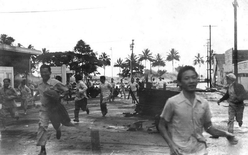
The central bayfront area was settled in 1913 by first-generation immigrants from Japan, who started businesses in Waiākea and named the area Shinmachi ("New Town").[10] Shinmachi was wiped out by the tsunami waves resulting from the 1946 Aleutian Islands earthquake on April 1, 1946; wave heights were estimated at 35 to 50 ft (11 to 15 m). Residents returned and rebuilt, only to have Shinmachi destroyed again by another tsunami on May 23, 1960, following the 1960 Valdivia earthquake.[11] A documentary film about Shinmachi was broadcast on local PBS stations in April 2021.[12]
Project Kaikoʻo
The Hawaiʻi County Board of Supervisors formed the Hawaii Redevelopment Agency (HRA) on May 31, and passed an ordinance banning further reconstruction in the flooded area. A 5-person Board of Commissioners was appointed on July 14, with Ralph Kiyosaki as the first chairman.[13]: 9 HRA decided to permanently relocate Shinmachi rather than rebuild and initiated Project Kaikoʻo ("rough seas"), completing the acquisition of land and relocation of residents by 1965. Approximately 300 acres (120 ha) of oceanfront land would be set aside as a green belt and buffer zone to absorb future tsunamis, including the Wailoa River State Recreation Area. At the edge of the high water mark from the 1960 tsunami, 40 acres (16 ha) of land were filled to an average elevation of 26 ft (7.9 m) above sea level, creating a parcel for a new commercial center and County offices along Kilauea Avenue.[13]: 12 [14]
Plans for Project Kaikoʻo were approved in March 1961; most businesses agreed to move to public lands zoned for light industrial uses near the airport, but residents were more stubborn and refused relocation. In some cases, land had to be condemned and the property seized.[13]: 13–14 600,000 cu yd (460,000 m3) of volcanic fill were used to create the new commercial center plateau, and the project received a strong endorsement in 1963 when the County decided to build its new center on the elevated site.[13]: 15
References
- Lloyd J. Soehren (2010). "lookup of wailoa river park ". in Hawaiian Place Names. Ulukau, the Hawaiian Electronic Library. Retrieved October 30, 2010.
- U.S. Geological Survey Geographic Names Information System: Wailoa River
- "South Hilo map 5". Shoreline access. on official Hawaiʻi County web site. Retrieved October 30, 2010.
- "Wailoa River State Recreation Area". official Hawaii's State Park web site. Hawai'i Department of Land and Natural Resources. Retrieved October 30, 2010.
- "Hawaii Arts Organizations". HI Art Magazine. Retrieved October 30, 2010.
- "Kamehameha Schools alumni from East Hawaiʻi are doing their part to honor and remember Kamehameha the Great" (PDF). Kamehameha Schools Alumni Association. Spring 2003. pp. 26, 28. Retrieved October 30, 2010.
- "Letter from Royal Order of Kamehameha I to Hawaii County council". February 6, 1997. Retrieved October 30, 2010.
- Burnett, John (June 23, 2019). "Korean War memorial dedicated in Hilo". Hawaii Tribune-Herald. Retrieved 26 May 2021.
- "Tadashi Sato, 82, Painter and Muralist, Dies". The New York Times. The Associated Press. June 11, 2005. Retrieved 26 May 2021.
- Brestovansky, Michael (May 20, 2019). "Researcher documents the story of Shinmachi". Hawaii Tribune-Herald. Retrieved 26 May 2021.
- Burnett, John (April 1, 2021). "Survivors reflect on devastating tsunami that struck Hilo 75 years ago". Hawaii Tribune-Herald. Retrieved 26 May 2021.
- "Shinmachi: Stronger Than a Tsunami premiering April 1". West Hawaii Today. March 19, 2021. Retrieved 26 May 2021.
- Project: Kaikoʻo (Report). Hawaii Redevelopment Agency. 1971.
- Clark, John R. K. (1985). "6. Hilo Bayfront Park". Beaches of the Big Island. Honolulu: University of Hawaii Press. pp. 17–18. ISBN 0-8248-0976-9. Retrieved 26 May 2021.
External links
| Wikimedia Commons has media related to Wailoa River State Recreation Area. |
- "Welcome to Wailoa Center". Wailoa Center.
- Urban Renewal Plan – Kaikoʻo Project – 1965 (Report). Hawaiʻi County Planning Department, Community Development Plans. 1965.
Другой контент может иметь иную лицензию. Перед использованием материалов сайта WikiSort.org внимательно изучите правила лицензирования конкретных элементов наполнения сайта.
WikiSort.org - проект по пересортировке и дополнению контента Википедии