geo.wikisort.org - River
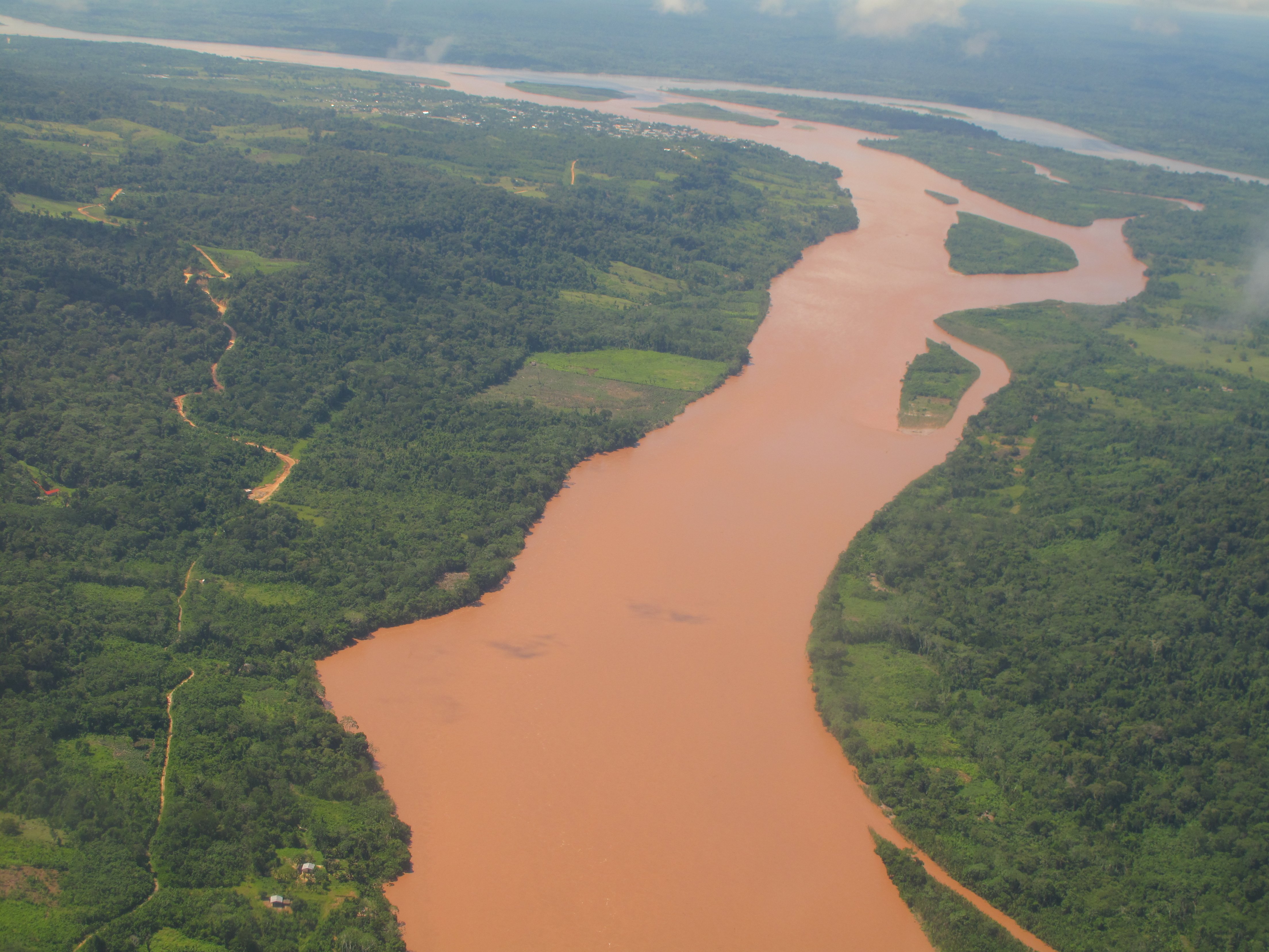
The Ucayali River (Spanish: Río Ucayali, IPA: [ˈri.o ukaˈʝali]) is the main headstream of the Amazon River. It rises about 110 km (68 mi) north of Lake Titicaca, in the Arequipa region of Peru and becomes the Amazon at the confluence of the Marañón close to Nauta city. The city of Pucallpa is located on the banks of the Ucayali.
This article needs additional citations for verification. (February 2015) |
| Ucayali River | |
|---|---|
 Confluence of the Tambo (from bottom) and Urubamba Rivers (background right) forming the Ucayali River (background left) | |
 Map of the Amazon Basin with the Ucayali River highlighted | |
| Location | |
| Country | Peru |
| Physical characteristics | |
| Source | confluence of the Tambo and Urubamba Rivers |
| • location | Atalaya, Ucayali, Peru |
| Mouth | Amazon River |
• location | confluence with Marañón River, Loreto, Peru |
| Length | 2,238 km (1,391 mi)[1] 1,460 km (910 mi)[2] |
| Basin size | 351,549 km2 (135,734 sq mi)[3] |
| Discharge | |
| • location | Requena, Peru |
| • average | (Period of data: 1990-2006)13,385 m3/s (472,700 cu ft/s)[4]
13,500 m3/s (480,000 cu ft/s) (Confluence of Marañón: ~13,800 m3/s (490,000 cu ft/s)) |
| • minimum | 3,000 m3/s (110,000 cu ft/s)[5] |
| • maximum | 28,000 m3/s (990,000 cu ft/s)[6] |
| Discharge | |
| • location | Pucallpa, Peru (Basin size: 260,733 km2 (100,670 sq mi) |
| • average | (Period of data: 1990-2006)8,931.2 m3/s (315,400 cu ft/s)[7] |
| Basin features | |
| Tributaries | |
| • left | Tambo, Pachitea, Aguaytia, Pisqui, Cushabatay |
| • right | Urubamba, Tamaya, Tapiche |
Description
The Ucayali, together with the Apurímac River, the Ene River and the Tambo River, is today considered the main headwater of the Amazon River, totaling a length of 2,669.9 kilometres (1,659.0 mi) from the source of the Apurímac at Nevado Mismi to the confluence of the Ucayali and Marañón Rivers:
- Apurímac River (total length): 730.7 km (454.0 mi)
- Ene River (total length): 180.6 km (112.2 mi)
- Tambo River (total length): 158.5 km (98.5 mi)
- Ucayali River (confluence with Tambo River to confluence with the Marañón): 1,600.1 km (994.3 mi)
Exploration
The Ucayali was first called San Miguel, then Ucayali, Ucayare, Poro, Apu-Poro, Cocama and Rio de Cuzco. Peru has organised many costly and ably-conducted expeditions to explore it. One of them (1867) claimed to have reached within 380 km (240 mi) of Lima, and the little steamer "Napo" found its way up the violent currents for 124 km (77 mi) above the junction with the Pachitea River, and as far as the Tambo River, 1,240 km (770 mi) from the confluence of the Ucayali with the Amazon. The "Napo" then succeeded in ascending the Urubamba River 56 km (35 mi) upstream from its junction with the Tambo, to a point 320 km (200 mi) north of Cuzco.
Navigation
Its width varies from 400–1,200 metres (1,300–3,900 ft), due to the large number of islands. The current runs from 5–6 kilometres per hour (3.1–3.7 mph), and a channel from 20–50 metres (66–164 ft) wide can always be found with a minimum depth of 1.5 m (4.9 ft). There are five difficult passes, due to the accumulation of trees and rafts of timber. Sometimes large rocks which have fallen from the mountains and spread over the river-bed cause whirlpools.
National Reserve
Ucayali is home to the Amazon river dolphin, giant otter, and the Amazonian manatee, which are abundant in Pacaya-Samiria National Reserve, close to Nauta. The southeastern border of the reserve is formed by the lower Ucayali River.
The river gives its name to the Ucayali Region of Peru and the Ucayali Province of the Loreto Region.
References
- (PDF) http://www.minem.gob.pe/minem/archivos/file/DGGAE/ARCHIVOS/estudios/EIAS%2520-%2520hidrocarburos/EIA/EIA%2520LOTE%2520131/SubCap%25201.6%2520Hidrolog%25C3%25ADa.pdf.
{{cite web}}: Missing or empty|title=(help) - Ziesler, R.; Ardizzone, G.D. (1979). "Amazon River System". The Inland waters of Latin America. Food and Agriculture Organization of the United Nations. ISBN 92-5-000780-9. Archived from the original on 8 November 2014.
- (PDF) http://www.minem.gob.pe/minem/archivos/file/DGGAE/ARCHIVOS/estudios/EIAS%2520-%2520hidrocarburos/EIA/EIA%2520LOTE%2520131/SubCap%25201.6%2520Hidrolog%25C3%25ADa.pdf.
{{cite web}}: Missing or empty|title=(help) - (PDF) http://repositorio.unsa.edu.pe/bitstream/handle/UNSA/3206/GFcoqujv.pdf.
{{cite web}}: Missing or empty|title=(help) - (PDF) http://www.minem.gob.pe/minem/archivos/file/DGGAE/ARCHIVOS/estudios/EIAS%2520-%2520hidrocarburos/EIA/EIA%2520EMERALD/3.0%2520LB%2520AMBIENTAL.pdf.
{{cite web}}: Missing or empty|title=(help) - (PDF) http://www.minem.gob.pe/minem/archivos/file/DGGAE/ARCHIVOS/estudios/EIAS%2520-%2520hidrocarburos/EIA/EIA%2520EMERALD/3.0%2520LB%2520AMBIENTAL.pdf.
{{cite web}}: Missing or empty|title=(help) - (PDF) http://repositorio.unsa.edu.pe/bitstream/handle/UNSA/3206/GFcoqujv.pdf.
{{cite web}}: Missing or empty|title=(help)
External links
| Wikimedia Commons has media related to Ucayali River. |
Authority control | |
|---|---|
| General |
|
| National libraries | |
На других языках
[de] Río Ucayali
Der Río Ucayali ist einer der beiden Quellflüsse des Amazonas in Südamerika. Er entsteht seinerseits durch den Zusammenfluss von Río Urubamba und Río Tambo bei Atalaya. Der Río Ucayali vereinigt sich im nordöstlichen Peru nahe dem Äquator mit dem kürzeren, jedoch mit einem rund 10 Prozent höheren mittleren Abfluss etwas größeren Río Marañón zum Amazonas.- [en] Ucayali River
[it] Ucayali (fiume)
Il Rio Ucayali, che nasce circa 140 kilometri a nord del Lago Titicaca, è il braccio principale del Rio delle Amazzoni. Quando si unisce al Rio Marañon, non lontano dalla città di Iquitos, inizia ad essere denominato ufficialmente Rio delle Amazzoni.[ru] Укаяли
Укая́ли[1] (исп. Ucayali) — река в Перу, правый приток Амазонки. Иногда Укаяли «включают в состав» Амазонки; в этом случае исток Укаяли считают истоком Амазонки.Другой контент может иметь иную лицензию. Перед использованием материалов сайта WikiSort.org внимательно изучите правила лицензирования конкретных элементов наполнения сайта.
WikiSort.org - проект по пересортировке и дополнению контента Википедии