geo.wikisort.org - River
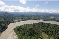
The Ene River (Spanish: Río Ene; Quechua: Iniy mayu) is a Peruvian river on the eastern slopes of the South American Andes.
This article needs additional citations for verification. (December 2009) |


Geography
Headwaters
The Ene is formed at 12°15′45″S 73°58′30″W at the confluence of the Mantaro River and the Apurímac River, circa 400 m above sea level, where the three Peruvian Regions Junín, Cusco, and Ayacucho meet.
The river flows in a northwesterly direction at a total length of 180.6 km.
The Ene River is part of the headwaters of the Amazon River whose origin is at the Mismi south of Cuzco where it first becomes Apurímac River, then the Ene River and Tambo River before its waters meet the Ucayali River which later forms the Amazon.
At 11°09′39″S 74°14′48″W the Ene River joins the Perené River at the town Puerto Prado, 295 m above sea level, and is called the Tambo from then on.
Threats
The proposed 2,200-megawatt Pakitzapango hydroelectric dam would flood much of the Ene River valley.[1] Protests by the Central Ashaninka del Rio Ene (CARE, Asháninka Center of the Ene River) and Ruth Buendia (president since 2005) have halted the construction.[1][2] For her efforts Buendia was awarded the Goldman Environmental Prize in 2014.[3][2]
References
- "Pakitzapango Dam". International Rivers. Retrieved April 30, 2016.
- Monti Aguirre (April 28, 2014). "Ruth Buendía of Peru Wins 2014 Goldman Environmental Prize". International Rivers. Retrieved April 30, 2016.
- "Prize Recipient: Ruth Buendia, 2014 South & Central America". Goldman Environmental Prize. Retrieved 3 June 2014.
External links
 Media related to Ene River at Wikimedia Commons
На других языках
[de] Río Ene
Der Río Ene ist der 153 km lange rechte Quellfluss des Río Tambo in der zentral in Peru gelegenen Region Junín.- [en] Ene River
[es] Río Ene
El río Ene es un río del Perú que constituye la parte superior del curso del río Ucayali, y, por tanto, parte también del curso principal del río Amazonas. Discurre por la vertiente oriental de los Andes peruanos, en la parte sur del país.Другой контент может иметь иную лицензию. Перед использованием материалов сайта WikiSort.org внимательно изучите правила лицензирования конкретных элементов наполнения сайта.
WikiSort.org - проект по пересортировке и дополнению контента Википедии