geo.wikisort.org - River
The Tompo (Russian: Томпо) is a river in the Sakha Republic (Yakutia), Russia, a right tributary of the Aldan, part of the Lena basin. River Tompo gives its name to the Tompo District. It flows across desolate regions, Topolinoye being the only inhabited place in the long course of the river.[1]
| Tompo | |
|---|---|
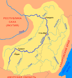 Aldan basin. The Tompo in the upper right | |
 Mouth location in Yakutia, Russia | |
| Location | |
| Country | Russian Federation |
| Physical characteristics | |
| Source | Elgi Plateau |
| • coordinates | 64°29′02″N 139°10′59″E |
| • elevation | 1,790 m (5,870 ft) |
| Mouth | Aldan River |
• coordinates | 62°42′24″N 134°42′34″E |
• elevation | 101 m (331 ft) |
| Length | 570 km (350 mi) |
| Basin size | 42,700 km2 (16,500 sq mi) |
| Basin features | |
| Progression | Aldan→ Lena→ Laptev Sea |
The Tompo is not navigable. The area of the river's drainage basin is 42,700 square kilometres (16,500 sq mi).[2]
Course
The Tompo originates in the southern slopes of the Elgi Plateau.[3] For about 400 km (250 mi), the river displays the characteristics of a typical mountain river, flowing within a deep and narrow valley bound by steep slopes.
In its uppermost course the Tompo runs roughly northward along the northern side of the Suntar-Khayata mountains; after roughly 80 km (50 mi) it turns and follows a generally westward direction for about 200 km (120 mi) through the southern part of the Elgi Plateau. Downstream from the mouth of the Delinya, its 2nd largest tributary, which flows from the central part of the Yana-Oymyakon Highlands, the Tompo bends SSE into a roughly 130 km (81 mi) long deep gorge, separating the Verkhoyansk Range proper to the northwest and the group of three parallel ranges formed by the Ulakhan-Bom, Sette-Daban and the Skalisty Range to the southeast. After the mouth of the Menkule River, it emerges from the mountains and, flowing in a southwesterly direction, enters the eastern side of the Central Yakutian Plain, where its valley becomes very wide and swampy, its riverbed dividing into lazily-flowing arms as the speed of the flow decreases. Finally the Tompo meets the right bank of the Aldan River, opposite Megino-Aldan village, upstream of the mouth of the Baray.[4][5]
Tributaries
The main tributaries of the Tompo are the 389 km (242 mi) long Khunkhada and 357 km (222 mi) long Delinya from the right, as well as the 225 km (140 mi) long Menkule and 186 km (116 mi) long Tomporuk from the left. There are 1,662 lakes in the basin of the Tompo with a total area of 43.9 km2 (16.9 sq mi).[3]
See also
References
- Google Earth
- Tompo - State Water Register of Russia
- Tompo- Water of Russia
- Томпо, Great Soviet Encyclopedia
- 1,000,000 scale Operational Navigation Chart; Sheet C-6
This Sakha Republic location article is a stub. You can help Wikipedia by expanding it. |
This article related to a river in Russia is a stub. You can help Wikipedia by expanding it. |
На других языках
[de] Tompo
Der Tompo (jakutisch und russisch Томпо) ist ein 570 km langer rechter Nebenfluss des Aldan in Nordostsibirien (Russland, Asien).- [en] Tompo
[it] Tompo
Il Tompo è un fiume della Russia siberiana orientale, affluente di destra dell'Aldan nel bacino della Lena. Scorre nel Tomponskij ulus della Sacha-Jakuzia.[ru] Томпо
Томпо́[2] — река в Якутии (Россия), правый приток Алдана.Другой контент может иметь иную лицензию. Перед использованием материалов сайта WikiSort.org внимательно изучите правила лицензирования конкретных элементов наполнения сайта.
WikiSort.org - проект по пересортировке и дополнению контента Википедии