geo.wikisort.org - River
The Teno River is a river located in the Maule Region of central Chile. It begins at the confluence of the Malo and Nacimiento rivers. The former originates north of Planchón volcano at Lagunas de Teno. The river flows initially northwest across the Andes. At the locality of Los Queñes, the Teno is joined by the Claro River, which is fed by glaciers of Planchón-Peteroa complex.
| Teno River | |
|---|---|
 Maule cuenca | |
| Location | |
| Country | Chile |
| Physical characteristics | |
| Mouth | |
• location | Mataquito River[1] |
| Length | 102 km (63 mi)[1] |
| Basin size | 1,590 km2 (610 sq mi)[1] |

Shortly after being crossed by the Pan-American Highway and by Chile's main railroad, the Teno River turns its course southwestward until it meets the Lontué River, about 10 kilometers west of Curicó near the locality of Sagrada Familia, forming the Mataquito River.
References
- Cuenca del río Mataquito Archived 2007-09-27 at the Wayback Machine
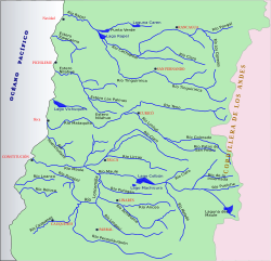
Hydrography of Maule Region | ||
|---|---|---|
| Rivers |  | |
| Waterfalls |
| |
| Lakes | ||
| Authority control |
|
|---|
This Maule Region location article is a stub. You can help Wikipedia by expanding it. |
На других языках
- [en] Teno River
[es] Río Teno
El río Teno es un curso natural de agua que nace en la confluencia de los ríos Malo y Nacimiento en la Región del Maule. Astaburuaga llama Teno al río a partir de las lagunas de Teno, a diferencia de Luis Risopatrón que llama río Malo al cauce superior.Текст в блоке "Читать" взят с сайта "Википедия" и доступен по лицензии Creative Commons Attribution-ShareAlike; в отдельных случаях могут действовать дополнительные условия.
Другой контент может иметь иную лицензию. Перед использованием материалов сайта WikiSort.org внимательно изучите правила лицензирования конкретных элементов наполнения сайта.
Другой контент может иметь иную лицензию. Перед использованием материалов сайта WikiSort.org внимательно изучите правила лицензирования конкретных элементов наполнения сайта.
2019-2026
WikiSort.org - проект по пересортировке и дополнению контента Википедии
WikiSort.org - проект по пересортировке и дополнению контента Википедии