geo.wikisort.org - River
The Shebelle River (Somali: Webi Shabeelle, Arabic: نهر شبيلي, Amharic: እደላ) begins in the highlands of Ethiopia, and then flows southeast into Somalia towards Mogadishu. Near Mogadishu, it turns sharply southwest, where it follows the coast. Below Mogadishu, the river becomes seasonal. During most years, the river dries up near the mouth of the Jubba River, while in seasons of heavy rainfall, the river actually reaches the Jubba and thus the Somali Sea.
| Shebelle River | |
|---|---|
 Map of the Jubba/Shebelle drainage basin | |
| Location | |
| Countries |
|
| Physical characteristics | |
| Source | |
| • location | near |
| • coordinates | 7.2201°N 39.4665°E |
| Mouth | |
• location | occasionally continues into the Jubba River, usually dries up near |
• coordinates | 0.1659°N 42.7727°E |
The Shebelle river's name is derived from the Somali term Webi Shabeelle, meaning "Leopard River". The Somali administrative regions consisting of Middle Shebelle and Lower Shabeelle are also named after the river.
Tributaries
The Shebelle has a number of tributaries, both seasonal and permanent rivers. They include:
- Erer River
- Galetti River
- Wabe River
The Fafen only reaches the Shebelle in times of heavy rainfall; its stream usually ends before reaching the main river.
History
Ajuran Empire
During the middle ages, the Shebelle river was under the control of the Ajuran Empire and was largely utilized for its plantations. Coming into prominence during the 13th century AD, the Ajuran monopolized the water resources of the Jubba and Shebelle Rivers. Through hydraulic engineering, they also constructed many of the limestone wells and cisterns of the state many of which are still in use today. Its rulers developed new systems for agriculture and taxation, which continued to be used in parts of the Horn of Africa as late as the 19th century.[1]
Through their control of the region's wells, the Garen rulers effectively held a monopoly over their nomadic subjects as they were the only hydraulic empire in Africa during their reign. Large wells made out of limestone were constructed throughout the state, which attracted Somali and Oromo nomads with their livestock. The centralized regulations of the wells made it easier for the nomads to settle disputes by taking their queries to government officials who would act as mediators. Long-distance caravan trade, a long-time practice in the Horn of Africa, continued unchanged in Ajuran times. Today, numerous ruined and abandoned towns throughout the interior of Somalia and the Horn of Africa are evidence of a once-booming inland trade network dating from the medieval period.[2]
With the centralized supervision of the Ajuran, farms in Afgooye, Bardhere and other areas in the Jubba and Shabelle valleys increased their productivity. A system of irrigation ditches known locally as Kelliyo fed directly from the Shebelle River and Jubba rivers into the plantations where sorghum, maize, beans, grain and cotton were grown during the gu (Spring in Somali) and xagaa (Summer in Somali) seasons of the Somali calendar. This irrigation system was supported by numerous dikes and dams. To determine the average size of a farm, a land measurement system was also invented with moos, taraab and guldeed being the terms used.
The urban centers of Mogadishu, Merca, Barawa, Kismayo and Hobyo and other respective ports became profitable trade outlets for commodities originating from the interior of the state. The Somali farming communities of the hinterland from Jubba and Shebella valleys brought their crops to the Somali coastal cities, where they were sold to local merchants who maintained a lucrative foreign commerce with ships sailing to and coming from Arabia, Persia, India, Venice, Egypt, Portugal, and as far away as Java and China.[3]
Modern period
The source of the Shebelle River is cultivated by the Arsi Oromo, Sidamo and mostly Somalis, respectively. It is surrounded by a sacred enclosure wooded with juniper trees, which as of 1951 was under the protection of a Muslim member of the Arsi.[4]
In 1989, with the help of Soviet engineers, the Melka Wakena dam was built on the upper reaches of the Shebelle River in the Bale Mountains. Producing 153 megawatts, this dam is Ethiopia’s largest hydroelectric generator.[5]
The recent history of the Shabelle is marked by frequent destructive flash floods. The Shabelle is said to have flooded every other year prior to the 1960s; that decade had only two devastating floods, the hidigsayley in 1965, and the soogudud in 1966. In the 1970s, the most devastating flood was the kabahay of 1978.[6] In 1996, floods devastated three woredas in Ethiopia. On 23 October 1999, the river unexpectedly flooded in the middle of the night, destroying homes and crops in 14 out of the 117 kebeles in Kelafo woreda, as well as 29 of the 46 kebeles in neighboring Mustahil woreda. According to the local authorities, 34 people and an estimated 750 livestock died, with 70,000 affected by the floods and in need of assistance.[7] Two more recent floods were the dawdle in 2003, when about 100 livestock and 119 people were washed away, and the flood of April 2005, when about 30,000 persons were surrounded by floodwaters and 2000 camels and 4000 shoats were washed away by the floods; some locals consider this the worst flood in 40 years.[6]
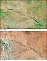 Satellite pictures showing the Shebelle valley in southern Somalia and Ethiopia before and during floods in 2005
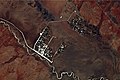 Astronaut photograph showing irrigation along the river


See also
- Geography of Ethiopia
- Geography of Somalia
- List of rivers of Ethiopia
Notes
- Njoku, Raphael Chijioke (2013). The History of Somalia. p. 26. ISBN 9780313378577. Retrieved 2014-02-14.
- Cassanelli (1982), p. 149.
- Journal of African History pg.50 by John Donnelly Fage and Roland Anthony Oliver
- J. Spencer Trimingham, Islam in Ethiopia (Oxford: Geoffrey Cumberlege for the University Press, 1952), p. 260.
- Lulseged Ayalew, "Something that We Need to Know about Our River’s Hydropower Potential" Archived 2006-05-22 at the Wayback Machine. Accessed 20 April 2006
- Ayele Gebre-Mariam, The Critical Issue of Land Ownership Archived 2020-03-03 at the Wayback Machine, Working Paper No. 2 (Bern: NCCR North-South, 2005), pp. 35f (accessed 19 January 2009)
- "Drought and Floods: Stress Livelihoods and Food Security in the Ethiopian Somali Region" UNDP Emergencies Unit for Ethiopia report, dated November 1999 (accessed 28 December 2008)
External links
- ReliefWeb: Somalia Integrated Phase Classification Maps (as of Sep 2008)[permanent dead link]
- Bale Mountains National Park
- Map of the Shebelle River basin at Water Resources eAtlas[permanent dead link]
- Hydropolitics in the Horn of Africa
| Authority control |
|
|---|
На других языках
[de] Shabelle
Der Shabelle (Somali Shabeelle, in Äthiopien auch Shebele oder Shebeli, amharisch ሸበሌ ወንዝ Šäbälle wänz, italienisch Scebeli; manchmal mit dem Zusatz Uebi, Webi, Wabi oder Wabe versehen) ist ein mindestens 1820 km langer[1] Fluss in Äthiopien und Somalia.- [en] Shebelle River
[es] Río Shebelle
El río Shebelle (en somalí: Webi Shabeelle, que significa «río Leopardo/Tigre») es un importante río de África oriental que nace en el macizo etíope, y luego fluye en dirección sudeste, hacia Mogadiscio, ya en Somalia. Cerca de Mogadiscio gira bruscamente al sudoeste, donde sigue la costa. Por debajo de Mogadiscio, el río se convierte en estacional. La mayoría de los años el río se seca cerca de la desembocadura del río Juba, mientras que en las estaciones de fuertes precipitaciones el río llega incluso hasta el Juba y así al océano Índico. El río da su nombre a las regiones administrativas somalís del río Shabeelle, siendo Shabeellaha Dhexe y Shabeellaha Hoose.[it] Uebi Scebeli
L'Uebi Scebeli (con numerose variazioni del nome, tra cui Shebelle, Shabele e Shabell; in somalo Shabeelle) è un fiume che nasce nell'Acrocoro Etiopico e scorre verso sudest entrando in Somalia, per poi passare non molto distante da Mogadiscio. Il nome significa "fiume dei leopardi". La sua esplorazione avvenne nel corso del XIX secolo, ma solo nel 1928/29 ne fu eseguito un rilievo sistematico dalle sorgenti alla foce da parte del Duca degli Abruzzi. Il Duca ne rimase così colpito che chiese, alla sua morte, di essere sepolto vicino alla sua riva.[ru] Уэби-Шабелле
Уэ́би-Шабе́лле[1][2][3] (в Сомали), также Уабе-Шэбэлле[1], Уа́би-Шэбэ́лле[4][5] (в Эфиопии)[2][3] (сомал. Webi Shabeelle, итал. Uebi Scebeli) — река в Сомали и Эфиопии. Берёт начало в Эфиопии, по территории которой протекает около 1000 км. В нижнем течении течёт практически параллельно берегу океана на расстоянии 10-15 км. Впадает в реку Джубба.Другой контент может иметь иную лицензию. Перед использованием материалов сайта WikiSort.org внимательно изучите правила лицензирования конкретных элементов наполнения сайта.
WikiSort.org - проект по пересортировке и дополнению контента Википедии