geo.wikisort.org - River
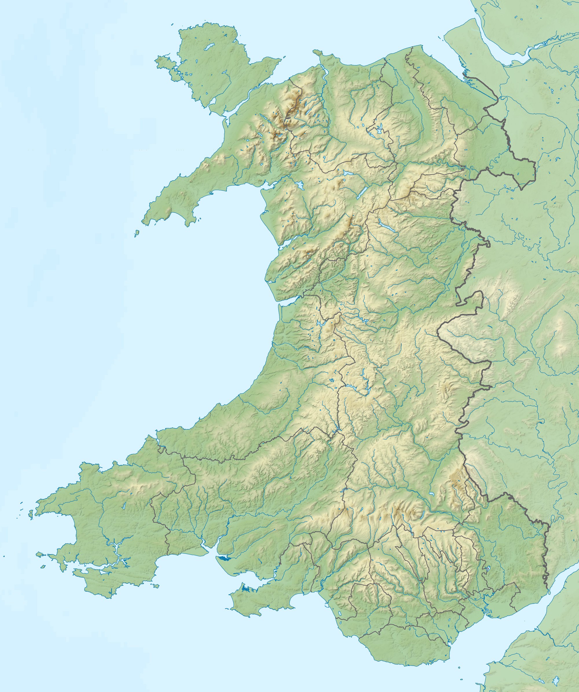
The River Teifi (Welsh: Afon Teifi pronounced [ˈtəɪvɪ]) in Wales forms the boundary for most of its length between the counties of Ceredigion and Carmarthenshire, and for the final 3 miles (4.8 km) of its total length of 76 miles (122 km), the boundary between Ceredigion and Pembrokeshire. Its estuary is northwest of Cardigan. Teifi has formerly been anglicised as "Tivy".[4][5]
| River Teifi Welsh: Afon Teifi | |
|---|---|
 Llyn Teifi, the source of the Teifi | |
 Mouth of the Teifi shown within Wales | |
| Location | |
| Country | Wales |
| Counties | Ceredigion, Carmarthenshire, Pembrokeshire |
| Physical characteristics | |
| Source | |
| • location | Llyn Teifi |
| • coordinates | 52.2918°N 3.7900°W |
| • elevation | 455 m (1,493 ft) |
| Mouth | |
• location | Cardigan Bay |
• coordinates | 52.103°N 4.689°W |
• elevation | 0 m (0 ft) |
| Length | 122 km (76 mi)[1] |
| Basin size | 1,008 km2 (389 sq mi)[2] |
| Discharge | |
| • location | Glan Teifi[3] |
| • average | 29.1 m3/s (1,030 cu ft/s)[3] |
| • maximum | 373.6 m3/s (13,190 cu ft/s) |
| Basin features | |
| Tributaries | |
| • left | Tyweli, Cych |
| • right | Dulas, Clettwr, Ceri |
Geography
The Teifi has its source in Llyn Teifi, one of several lakes known collectively as the Teifi Pools. These are situated towards the north of the county of Ceredigion; the source is in the Cambrian Mountains at 1,493 feet (455 m). This wide area of Mid-Wales, with a very sparse population, is part of what is sometimes called the "Desert of Wales". The river flows past Strata Florida Abbey and then through Pontrhydfendigaid before turning broadly southwest. Here it passes through Cors Caron, one of the great raised mires of Britain also known as Tregaron Bog or Cors Goch Glanteifi (translates from Welsh as red bog on the banks of the Teifi).[6] From here the river descends through pastures and bogs forming meanders on farmland below. Several small tributaries join from the valley with gorges, rocky and tree-lined sections also in the area.
Over the next 30 miles (48 km), the Teifi meanders southwest in a gentle arc passing through Tregaron, Llanddewi Brefi, Cwmann, Lampeter, Llanybydder, Llandysul, Newcastle Emlyn, and Cenarth. The river is tidal below Llechryd, descending through the steep-sided Cilgerran Gorge to Cardigan. West of Cardigan and St Dogmaels, the river broadens into a wide estuary with Poppit Sands on its west bank and Gwbert on its east bank as it enters Cardigan Bay.
On the lower parts of the river the wildlife is rich. There is a large variety ranging from water-crowfoot to Atlantic salmon as well as otters, wetland birds and multi fruited river moss. There have also been sightings of bottle-nosed dolphins where the river opens into the estuary.[7]
It is sometimes asserted that the Afon Tywi at 75 miles (121 km) and Afon Teifi at 76 miles (122 km) are the longest rivers wholly in Wales[8] though at about 78 miles (126 km), the River Usk exceeds both.[9]
The river is susceptible to flooding and there were some heavy floods in 2007 and 2008. If the swollen river is backed up by a high tide, flooding can occur in Cardigan[10] and as far up river as Llechryd.[11] The most recent flooding was in December 2015.[12]
The principal tributaries of the Teifi (ordered from source to sea) are as follows: Afon Mwyro, Nant Glasffrwd, Afon Meurig, Afon Fflur, Camddwr Fach, Camddwr, Brennig, Nant Carfan, Afon Brefi, Nant Digonest, Nant Clywedog, Ffrwd Cynon, Nant Gou, Nant Dulas, Nant Hathren, Nant Eiddig, Nant y Gwragedd, Nant Dolgwm, Afon Granell, Afon Duar, Nant Hust, Nant Ceiliog, Nant Caradog, Nant Cwm-du, Nant Cledlyn, Nant Fylchog, Afon Clettwr, Nant Wern-macwydd, Gwenffrwd, Afon Cerdin, Afon Tyweli, Nant Merwydd, Hoffnant, Afon Gwr-fach, Afon Siedi, Camnant, Nant Bachnog, Nant Iago, Nant Bargod, Afon Cynllo, Afon Cwm-wern, Nant Halen, Afon Arad, Nant Sarah, Afon Ceri, Afon Nawmor, Afon Hirwaun, Afon Cych, Afon Eifed, Nant Arberth, Afon Morgenau, Afon Plysgog, Nant Rhyd-y-fuwch, Afon Piliau, Afon Mwldan, Nant Degwen, Nant-y-ferwig.
Geology and landscape
The Teifi and its tributaries are underlain by ancient Ordovician and Silurian mudstones which have been extensively glaciated during the ice ages. The resultant landform is one of gently rolling hills supporting a range of agriculture in which dairy and sheep farming dominate. Ceredigion had the reputation of supplying London with its milk in the 19th century. The landscapes of the Teifi valley are very attractive and the Teifi is considered by many to be one of the most beautiful rivers in Wales.
Teifi Pools, the source of the Teifi, are a series of small upland lakes left by past glacial activity. The lakes are acid in nature. Some have been enlarged by damming and now provide a source of drinking water. The very extensive raised mire above Tregaron acts as a huge sponge at the head of the river and evens out extremes in flow.
Rapids and waterfalls are uncommon but the examples at Henllan and, especially at Cenarth, are noteworthy and have been extensively photographed and painted because of the beauty of the landscape. A dramatic painting of the falls was made by Frank Miles and is now at Nottingham City Museum. Miles's father inherited Cardigan Priory from his father, Philip John Miles, but lived in Nottinghamshire as Rector of Bingham.[13]
The river enters a narrow gorge between Llechryd and Cilgerran, the sides of which are thickly wooded with a distinctive under-storey flora of wood rush.
SSSI
| Site of Special Scientific Interest | |
| Location | Ceredigion |
|---|---|
| Grid reference | SN5153250832 |
| Interest | Biological and Geological |
| Area | 778.18 ha |
| Notification | 1997 |
The Teifi has been designated as a Site of Special Scientific Interest (SSSI) since December 1997 in an attempt to protect the rare and unique features and species within it. This SSSI has been notified as being of both geological and biological importance. It is protected by law.[14] The site has an area of 778.18 hectares and is managed by Natural Resources Wales.
Hydrology

The catchment of the river is estimated to be 1,008 square kilometres (389 sq mi)[2] yielding an average flow at Glan Teifi, just upstream of Llechryd Bridge, of 29.126 m³/s.[3] The maximum recorded flow between 1959 and 2011 was 373.6 m³/s on 18 October 1987.[3] The average annual rainfall varies from 1,552 millimetres (61.1 in) in the upper catchment to 1,176 millimetres (46.3 in) in the lower catchment, which is higher than the average for United Kingdom at 1,101 millimetres (43.3 in).[15]
Culture and history

The Teifi valley has been inhabited since pre-history. There are many remains of Iron Age and Stone Age man including cromlechs (burial chambers) and standing stones. The remains of a medieval abbey stand at Strata Florida with some excellent examples of encaustic tiles on the floors. The river flows near to the Lampeter campus of the University of Wales, Trinity Saint David, its predecessor, the University of Wales, Lampeter (est. 1822) having been the oldest university established in Wales. The river forms the southern boundary of the hamlet of Pen-y-wenallt.
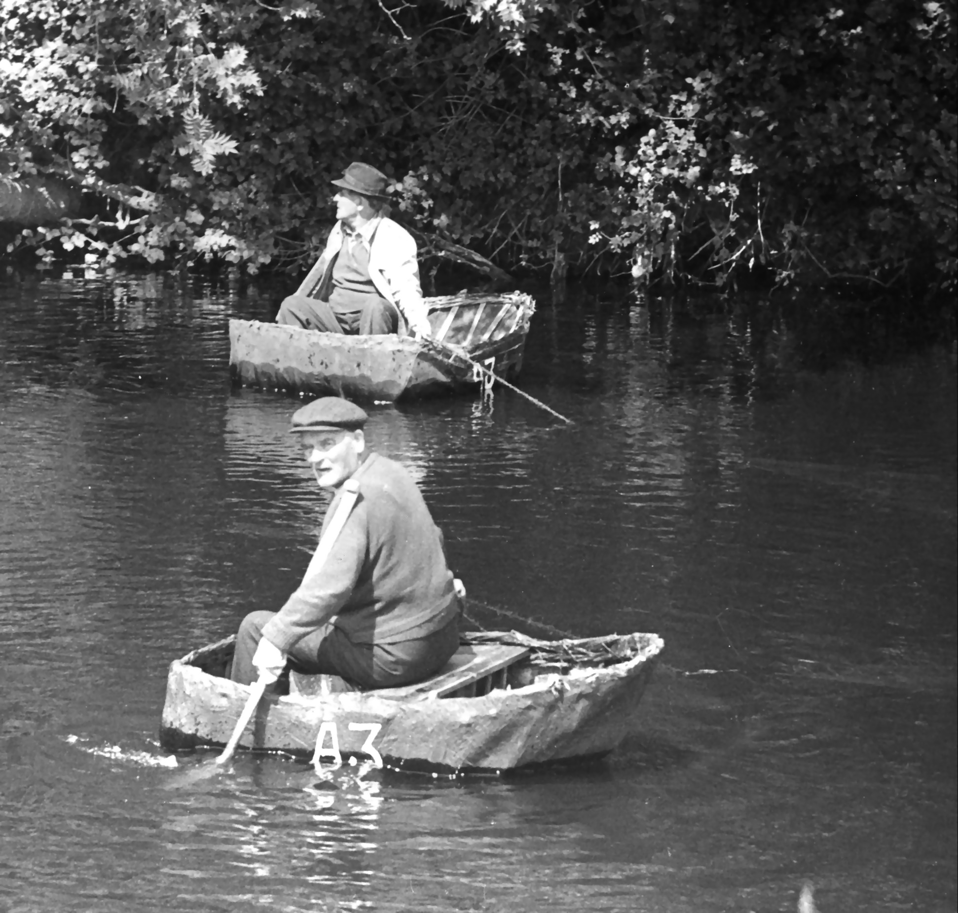
Between Cenarth and Cardigan, there is an ancient tradition of fishing and travel using coracles – very simple light-weight boats made of bent sticks covered with waterproofed hide or skins. These are paddled by a single oar used at the front of the craft which requires great skill. The principal use for coracles is for salmon fishing using nets. This form of fishing is now very tightly controlled and the right to fish in this way is passed down from father to son. There is also an age-old tradition of illegal salmon and sea-trout fishing in the lower Teifi. In 1188 Giraldus Cambrensis observed what is thought to have been the last colony of European beaver in England or Wales on the Teifi.
See also
- Cardigan Castle
- Cenarth Falls
- Cilgerran Castle
- Coedmor National Nature Reserve
- Teifi Valley Railway
References
- "River Teifi". Countryside Council for Wales. Archived from the original on 21 February 2014. Retrieved 4 February 2014.
- "First Water Resources Survey : Report", South West Wales River Authority, Published 1970, Page 41; Table 1
- "62001-Teifi at Glanteifi". The National River Flow Archive. Centre for Ecology & Hydrology. Retrieved 4 February 2014.
- "Felindre, River Tivy (Avon Teifi) c.1955". Francis Frith. Retrieved 10 August 2019.
- "River Tivy". Bartleby.com. Retrieved 11 August 2019.
- "Y Gors Goch".
- "River Teifi SAC". Archived from the original on 26 February 2014. Retrieved 6 June 2014.
- Davies, John; Jenkins, Nigel; Baines, Menna; Lynch, Peredur I., eds. (2008). The Welsh Academy encyclopaedia of Wales. Cardiff: University of Wales Press. pp. 894 & 855. ISBN 978-0-7083-1953-6.
- "Usk Management Catchment Summary" (PDF). Natural Resources Wales. Retrieved 25 April 2020.
- "30 homes flooded in Cardigan after "worst ever" flood". Carmarthen Journal. 3 January 2014. Retrieved 30 January 2016.
- "Resident marooned in home after River Teifi bursts banks". BBC. 21 December 2015. Retrieved 30 January 2016.
- "This is the scene in Pembrokeshire as further flood warnings issued across Wales". Wales Online. 22 December 2015. Retrieved 30 January 2016.
- "Salmon Leap, Cenarth Falls, Cardiganshire". Art UK. Retrieved 30 January 2016.
- "Countryside Council for Wales website (Natural Resources Wales since 2013)". Archived from the original on 1 January 2014. Retrieved 6 June 2014.
- "Climate tables UK 1961-90". Met Office. Retrieved 10 May 2013.
| Principal settlements |  | |
|---|---|---|
| Communities |
| |
| Towns and villages |
| |
| Universities and colleges |
| |
| Rivers | ||
| Castles |
| |
| Islands | ||
| Topics |
| |
| Authority control |
|
|---|
На других языках
[de] Teifi (Fluss)
Der River Teifi (Afon Teifi) ist ein Fluss in der Grafschaft Ceredigion, Wales, der unterhalb Cardigan ins Meer mündet. Das Einzugsgebiet des Flusses wird auf 1008 Quadratkilometer geschätzt. Die durchschnittliche jährliche Abflussmenge bei Glan Teifi beträgt 31,026 m³/s. Die maximale aufgezeichnete Abflussmenge (bis 1970) wurde am 17. Dezember 1965 mit 269,7 m³/s aufgezeichnet. Die durchschnittliche Niederschlagsmenge variiert von 155 mm im Jahr am Oberlauf bis zu 1176 mm im Jahr am Unterlauf des Flusses.- [en] River Teifi
[it] Teifi (fiume)
Il Teifi è un fiume di 122 km[1][2] del Galles centro-meridionale, che scorre tra le contee del Carmarthenshire, del Ceredigion e del Pembrokeshire[1][2]: nasce dal Lago Teifi (Llyn Teifi)[2][3], uno dei "Teifi Pools"[1][3], nei Monti Cambrici[1][3] e sfocia nella baia di Cardigan[1]. È il secondo fiume per lunghezza del Galles dopo il fiume Towy.[2]Другой контент может иметь иную лицензию. Перед использованием материалов сайта WikiSort.org внимательно изучите правила лицензирования конкретных элементов наполнения сайта.
WikiSort.org - проект по пересортировке и дополнению контента Википедии