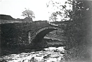
 The "Roman Bridge" over the River Goyt between New Mills and Marple Bridge is actually 17th century.
 The Goyt (right) meets the Tame in Stockport to form the Mersey.
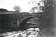 Goyts Bridge – the packhorse bridge (see Errwood Reservoir above) was partly broken in 1960, but restored when it was moved.
 River Goyt at Furness Vale (1968) when the colour depended on discharges from the calico print mills in the valley.
geo.wikisort.org - River
The River Goyt is a tributary of the River Mersey in North West England.
| River Goyt | |
|---|---|
 | |
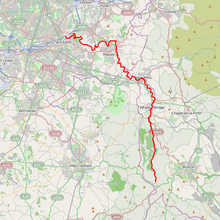 The River Goyt is highlighted in red Coordinates: 53.41420°N 2.15689°W | |
| Location | |
| Country | England |
| Physical characteristics | |
| Source | |
| • location | Axe Edge Moor, Derbyshire |
| • elevation | 520 m (1,710 ft)[1] |
| Mouth | |
• location | River Mersey |
• elevation | 40 m (130 ft)[2] |
| Length | 48.844 km (30.350 mi) |
| Basin features | |
| Progression | Mersey—Irish Sea |
| Tributaries | |
| • left | Todd Brook |
| • right | Sett, Etherow |
| River Goyt | ||||||||||||||||||||||||||||||||||||||||||||||||||||||||||||||||||||||||||||||||||||||||||||||||||||||||||||||||||||||||||||||||||||||||||||||||||||||||||||||||||||||||||||||||||||||||||||||||||||||||||||||||||
|---|---|---|---|---|---|---|---|---|---|---|---|---|---|---|---|---|---|---|---|---|---|---|---|---|---|---|---|---|---|---|---|---|---|---|---|---|---|---|---|---|---|---|---|---|---|---|---|---|---|---|---|---|---|---|---|---|---|---|---|---|---|---|---|---|---|---|---|---|---|---|---|---|---|---|---|---|---|---|---|---|---|---|---|---|---|---|---|---|---|---|---|---|---|---|---|---|---|---|---|---|---|---|---|---|---|---|---|---|---|---|---|---|---|---|---|---|---|---|---|---|---|---|---|---|---|---|---|---|---|---|---|---|---|---|---|---|---|---|---|---|---|---|---|---|---|---|---|---|---|---|---|---|---|---|---|---|---|---|---|---|---|---|---|---|---|---|---|---|---|---|---|---|---|---|---|---|---|---|---|---|---|---|---|---|---|---|---|---|---|---|---|---|---|---|---|---|---|---|---|---|---|---|---|---|---|---|---|---|---|---|
| ||||||||||||||||||||||||||||||||||||||||||||||||||||||||||||||||||||||||||||||||||||||||||||||||||||||||||||||||||||||||||||||||||||||||||||||||||||||||||||||||||||||||||||||||||||||||||||||||||||||||||||||||||
Etymology
The name Goyt may be derived from the Middle English gote, meaning "a watercourse, a stream".[3] Derivation from the Welsh gwyth meaning "vein" has been suggested, but described as "doubtful".[4]
Course
The Goyt rises on the moors of Axe Edge, near the River Dane and the Cat and Fiddle Inn. The area is known as the Upper Goyt Valley. The old Cat and Fiddle Road from Buxton to Macclesfield crosses the river just as it turns northwards to flow down its well-known valley. The river then flows under Derbyshire Bridge, which was the old boundary between Derbyshire and Cheshire. Later it reaches an old packhorse bridge that was moved when Errwood reservoir was built in the 1960s (see photo below). Further downstream there is another reservoir, the Fernilee Reservoir, built in 1938.[5] The original line of the Cromford and High Peak Railway can be seen near this point.
The Goyt then passes through Taxal and Horwich End where it is joined by the Todd Brook. Thereafter it passes through Whaley Bridge, New Mills (where it is joined by the River Sett) and Marple Bridge. Having been joined by the River Etherow, the Goyt joins the River Tame at Stockport, forming the River Mersey.
The section of the Goyt valley between Etherow Country Park and Whaley Bridge is followed by the Goyt Way, a 10-mile (16 km) walking route and part of the longer Midshires Way.[6]
The River Goyt is reputedly haunted by the ghost of a girl whose Royalist lover drowned in the river.[7]
Pollution
The river's Environment Agency pollution classification changed from moderate to poor in its lower section from the Etherow to the Mersey in 2016,[8] and in 2015 for the New Mills to Whaley Bridge length.[9] Otherwise the quality is moderate.[10][11]
Tributaries
- Poise Brook (L)
- Ochreley Brook (R)
- Torkington Brook (L)
- Marple Brook (R)
- Padden Brook ?
- St Chad's Brook ?
- River Etherow (R)
- Marple Bridge Brook ? (R)
- Hollywood Brook ? (R)
- Mellor Brook ? (R)
- Linnet Brook ? (R)
- Strines Brook ? (R)
- Higgin's Brook ? (L)
- River Sett (R)
- River Kinder (R)
- Upper Brook ? (L)
- William Brook ? (R)
- Blackshaws Brook ? (L)
- Red Brook (L)
- River Kinder (R)
- Shedyard Brook ? (R)
- Waterside Brook ? (R)
- Green Botham Brook ? (R)
- Todd Brook (L)
- Gnathole Brook (L)
- Carr Brook (R)
- Randal Carr Brook (R)
- Meveril Brook (L)
- Brook Houses Brook (R)
- Meveril Brook (L)
Gallery


See also
List of mills in New Mills area
References
Template:Attached KML/River Goyt
KML is from Wikidata
- Environment Agency (March 2004). "The Tame, Goyt and Etherow catchment abstraction management strategy". Environment Agency North West, Warrington. p. 6. Archived from the original (pdf) on 27 September 2007. Retrieved 13 March 2007.
- Boyce, D (August 2005). "Mersey and Bollin Catchment abstraction management strategy". Environment Agency North West, Warrington. p. 5. Archived from the original (pdf) on 27 September 2007. Retrieved 13 March 2007.
- "The place-names of England and Wales". Retrieved 17 July 2017.
- Studia Celtica. University of Wales Press. 2006. p. 47. Retrieved 15 June 2019.
- "History". Goyt Valley Online. Retrieved 14 August 2019.
- "Goyt Way". Long Distance Walkers Association. Retrieved 26 March 2018.
- Ash, Russell (1973). Folklore, Myths and Legends of Britain. Reader's Digest Association Limited. p. 372. ISBN 9780340165973.
- "Catchment Data Explorer - Goyt (Etherow to Mersey)". environment.data.gov.uk. Retrieved 14 August 2019.
- "Catchment Data Explorer - River Goyt (Sett to Etherow)". environment.data.gov.uk. Retrieved 15 August 2019.
- "Catchment Data Explorer - River Goyt (Sett to Etherow)". environment.data.gov.uk. Retrieved 14 August 2019.
- "Catchment Data Explorer - River Goyt (Source to Randall Carr Brook)". environment.data.gov.uk. Retrieved 14 August 2019.
Further reading
"The Goyt Valley (Fact Sheet: 16)" (PDF). Peak District National Park Authority. Archived from the original (PDF) on 12 May 2013. Retrieved 28 April 2014.
Authority control | |
|---|---|
| General |
|
| National libraries | |
На других языках
[de] River Goyt
Der River Goyt ist ein Fluss im Nordwesten Englands und – zusammen mit dem Etherow und dem Tame – einer der drei Quellflüsse des Mersey. Er entspringt in den Mooren von Axe Edge in einer Gegend, die als oberes Goyttal bekannt ist. Nach seiner Vereinigung mit dem Etherow fließt er bei Stockport mit dem Tame zusammen, um dann als Mersey weiterzufließen.- [en] River Goyt
Текст в блоке "Читать" взят с сайта "Википедия" и доступен по лицензии Creative Commons Attribution-ShareAlike; в отдельных случаях могут действовать дополнительные условия.
Другой контент может иметь иную лицензию. Перед использованием материалов сайта WikiSort.org внимательно изучите правила лицензирования конкретных элементов наполнения сайта.
Другой контент может иметь иную лицензию. Перед использованием материалов сайта WikiSort.org внимательно изучите правила лицензирования конкретных элементов наполнения сайта.
2019-2026
WikiSort.org - проект по пересортировке и дополнению контента Википедии
WikiSort.org - проект по пересортировке и дополнению контента Википедии