geo.wikisort.org - River
The River Dun (historically known as Bedwyn Brook) is a tributary of the River Kennet, flowing through Wiltshire and Berkshire in England.[1] Its main source is in the parish of Great Bedwyn, Wiltshire and it flows 16 kilometres (10 mi) in a northeasterly direction into Berkshire. It discharges into the Kennet at Hungerford,[2][3] which has a smaller average flow and width upstream of that point.
This article needs additional citations for verification. (February 2018) |
| River Dun Bedwyn Brook | |
|---|---|
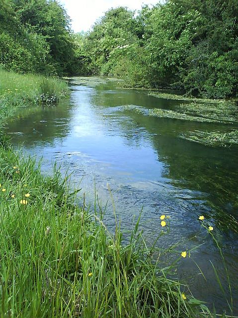 River Dun at Freeman's Marsh, before reaching Hungerford | |
| Location | |
| Country | England |
| Counties | Wiltshire, Berkshire |
| Towns | Great Bedwyn, Hungerford |
| Physical characteristics | |
| Source | |
| • location | Great Bedwyn, Wiltshire, United Kingdom |
| • coordinates | 51.37109°N 1.60664°W |
| • elevation | 120 m (390 ft) |
| Mouth | River Kennet |
• location | Hungerford, Berkshire, United Kingdom |
• coordinates | 51.412169°N 1.494023°W |
• elevation | 90 m (300 ft) |
| Length | 16 km (9.9 mi) |
The Dun valley is an important transport route through the high chalklands between the London Basin to the east and the Vale of Pewsey to the west. It is the route by which the Kennet and Avon Canal (linking London and Bristol) enters the Thames basin from the Vale of Pewsey, crossing the watershed with the aid of the Bruce Tunnel and Crofton Pumping Station. The later Reading to Plymouth railway linking London and the south-west also follows the valley.
The Dun has two named tributaries: the Froxfield Stream joins on the left between Little Bedwyn and Hungerford, and the Shalbourne Stream on the right above Hungerford.[4] During or after the building of the Kennet and Avon Canal in the late 18th century, the Shalbourne was diverted into it. In 2000 the stream was returned to its original course, rejoining the Dun via a culvert under the canal.[5]
References
- Blackmore, Mike (April 2014). "River Dun, Froxfield, Wiltshire" (PDF). wildtrout.org. p. 4. Retrieved 28 February 2018.
- "Upper Dun". Catchment Data Explorer. Environment Agency. Retrieved 28 February 2018.
{{cite web}}: CS1 maint: url-status (link) - "Kennet and Avon Canal and Dun above Hungerford". environment.data.gov.uk. Retrieved 28 February 2018.
- "Kennet and Avon Canal and Dun above Hungerford". Catchment Data Explorer. Environment Agency. Retrieved 21 January 2020.
{{cite web}}: CS1 maint: url-status (link) - "Southern Streams". The Kennet Catchment. Retrieved 21 January 2020.
{{cite web}}: CS1 maint: url-status (link)
| Wikimedia Commons has media related to River Dun, Wiltshire. |
| Rivers |
|
|---|---|
This Berkshire location article is a stub. You can help Wikipedia by expanding it. |
This article about a location in Wiltshire is a stub. You can help Wikipedia by expanding it. |
На других языках
[de] River Dun (River Kennet)
Der River Dun ist ein Fluss in Wiltshire und Berkshire, England. Er entsteht in Great Bedwyn. Sein Lauf in nördlicher bzw. nordöstlicher und schließlich östlicher Richtung folgt in direkter Nachbarschaft zum Kennet-und-Avon-Kanal meistens auf der nördlichen Seite des Kanals, nur zwischen Froxfield und westlich von Hungerford verläuft er auf der südlichen Seite. Der Dun mündet östlich von Hungerford in den River Kennet.- [en] River Dun (River Kennet)
[it] Dun (fiume)
Il Dun è un fiume che scorre nello Wiltshire e nel Berkshire in Inghilterra. Nasce nei pressi di Great Bedwyn, Wiltshire e scorre, per il suo intero corso, in direzione est-nord-est, in Berkshire dove confluisce nel fiume Kennet a Hungerford.Другой контент может иметь иную лицензию. Перед использованием материалов сайта WikiSort.org внимательно изучите правила лицензирования конкретных элементов наполнения сайта.
WikiSort.org - проект по пересортировке и дополнению контента Википедии