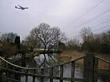
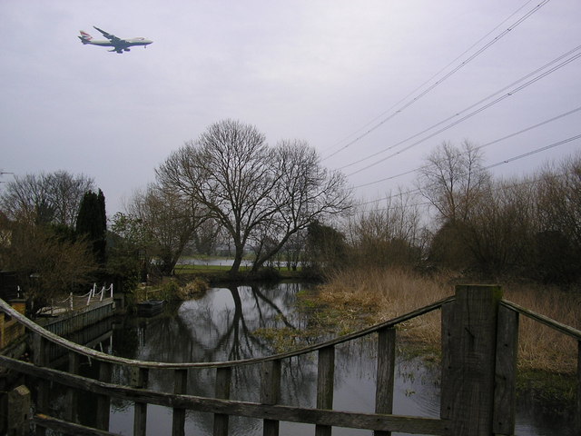
 In the village of Colnbrook
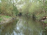 South of Colnbook
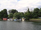 On discharge at the River Thames
geo.wikisort.org - River
River Colne (Hertfordshire) | |||||||||||||||||||||||||||||||||||||||||||||||||||||||||||||||||||||||||||||||||||||||||||||||||||||||||||||||||||||||||||||||||||||||||||||||||||||||||||||||||||||||||||||||||||||||||||||||||||||||||||||||||||||||||||||||||||||||||||||||||||||||||||||||||||||||||||||||||||||||||||||||||||||||||||||||||||||||||||||||||||||||||||||||||||||||||||||||||||||||||||||||||||||||||||||||||||||||||||||||||||||||||||||||||||||||||||||||||||||||||||||||||||||||||||||||||||||||||||||||||||||||||||||||||||||||||||||||||||||||||||||||||
|---|---|---|---|---|---|---|---|---|---|---|---|---|---|---|---|---|---|---|---|---|---|---|---|---|---|---|---|---|---|---|---|---|---|---|---|---|---|---|---|---|---|---|---|---|---|---|---|---|---|---|---|---|---|---|---|---|---|---|---|---|---|---|---|---|---|---|---|---|---|---|---|---|---|---|---|---|---|---|---|---|---|---|---|---|---|---|---|---|---|---|---|---|---|---|---|---|---|---|---|---|---|---|---|---|---|---|---|---|---|---|---|---|---|---|---|---|---|---|---|---|---|---|---|---|---|---|---|---|---|---|---|---|---|---|---|---|---|---|---|---|---|---|---|---|---|---|---|---|---|---|---|---|---|---|---|---|---|---|---|---|---|---|---|---|---|---|---|---|---|---|---|---|---|---|---|---|---|---|---|---|---|---|---|---|---|---|---|---|---|---|---|---|---|---|---|---|---|---|---|---|---|---|---|---|---|---|---|---|---|---|---|---|---|---|---|---|---|---|---|---|---|---|---|---|---|---|---|---|---|---|---|---|---|---|---|---|---|---|---|---|---|---|---|---|---|---|---|---|---|---|---|---|---|---|---|---|---|---|---|---|---|---|---|---|---|---|---|---|---|---|---|---|---|---|---|---|---|---|---|---|---|---|---|---|---|---|---|---|---|---|---|---|---|---|---|---|---|---|---|---|---|---|---|---|---|---|---|---|---|---|---|---|---|---|---|---|---|---|---|---|---|---|---|---|---|---|---|---|---|---|---|---|---|---|---|---|---|---|---|---|---|---|---|---|---|---|---|---|---|---|---|---|---|---|---|---|---|---|---|---|---|---|---|---|---|---|---|---|---|---|---|---|---|---|---|---|---|---|---|---|---|---|---|---|---|---|---|---|---|---|---|---|---|---|---|---|---|---|---|---|---|---|---|---|---|---|---|---|---|---|---|---|---|---|---|---|---|---|---|---|---|---|---|---|---|---|---|---|---|---|---|---|---|---|---|---|---|---|---|---|---|---|---|---|---|---|---|---|---|---|---|---|---|---|---|---|---|---|---|---|---|---|---|---|---|---|---|---|---|---|---|---|---|---|---|---|---|---|---|---|---|---|---|---|---|---|---|---|---|---|---|---|---|---|---|---|---|---|---|---|---|---|---|---|---|---|---|---|---|---|---|---|---|---|---|---|---|---|---|---|---|---|---|---|---|---|---|---|---|
| |||||||||||||||||||||||||||||||||||||||||||||||||||||||||||||||||||||||||||||||||||||||||||||||||||||||||||||||||||||||||||||||||||||||||||||||||||||||||||||||||||||||||||||||||||||||||||||||||||||||||||||||||||||||||||||||||||||||||||||||||||||||||||||||||||||||||||||||||||||||||||||||||||||||||||||||||||||||||||||||||||||||||||||||||||||||||||||||||||||||||||||||||||||||||||||||||||||||||||||||||||||||||||||||||||||||||||||||||||||||||||||||||||||||||||||||||||||||||||||||||||||||||||||||||||||||||||||||||||||||||||||||||
The Colne Brook is a river in England that is a distributary of the River Colne which runs from Uxbridge Moor, there forming the western border of Greater London, to the River Thames just below Bell Weir Lock in Hythe End, Wraysbury, Berkshire.[n 1]
Course
On leaving the Colne at Uxbridge Moor in the Colne Valley regional park, the Colne Brook flows close by to its west until West Drayton then passes under the M25 motorway at the M4 "Thorney interchange", enters Berkshire and flows through the village of Colnbrook. South of there it receives some water from the Poyle Channel, after which that becomes the Wraysbury River watering the west of Staines Moor. Then the Brook runs between Horton's centre and another residential part of Horton on Coppermill Road adjoining Wraysbury Reservoir. Colne Brook has its end stage in the easternmost parish of the Royal Borough of Windsor and Maidenhead. It passes Wraysbury railway station then adjoins gravel-extraction-made lakes of Wraysbury, a Site of Special Scientific Interest, before running into the River Thames: between the M25 Runnymede Bridge and Bell Weir Lock upstream.[1]
Images of the river and on discharge at the River Thames


See also
- Tributaries of the River Thames
- List of rivers of England
Notes and references
- Notes
- In the same way as Datchet, Eton and Slough, all parts of Berkshire mentioned were historically Buckinghamshire.
- References
| Non-tributaries | |
|---|---|
| Tributaries | |
| Passing Denham/Iver |
|
| Man-made | |
На других языках
[de] Colne Brook
Der Colne Brook ist ein Wasserlauf in Buckinghamshire, England. Er entsteht als Abzweig des River Colne bei Uxbridge auf der Grenze von Greater London und Buckinghamshire. Während der River Colne weiter in Greater London verläuft, wendet sich der Colne Brook nach Westen und fließt nach dem Unterqueren des M25 motorway in südlicher Richtung. Zwischen Iver und Thorney verläuft er noch einmal östlich der M25. Am Autobahnkreuz von M25 und M4 motorway unterquert er erst die M25 nach Westen und dann die M4 nach Süden und verläuft dann westlich der M25 bis zu seiner Mündung in die Themse an der M25 Runnymede Bridge flussabwärts des Bell Weir Lock.- [en] Colne Brook
Текст в блоке "Читать" взят с сайта "Википедия" и доступен по лицензии Creative Commons Attribution-ShareAlike; в отдельных случаях могут действовать дополнительные условия.
Другой контент может иметь иную лицензию. Перед использованием материалов сайта WikiSort.org внимательно изучите правила лицензирования конкретных элементов наполнения сайта.
Другой контент может иметь иную лицензию. Перед использованием материалов сайта WikiSort.org внимательно изучите правила лицензирования конкретных элементов наполнения сайта.
2019-2026
WikiSort.org - проект по пересортировке и дополнению контента Википедии
WikiSort.org - проект по пересортировке и дополнению контента Википедии