geo.wikisort.org - River
The Ramu River is a major river in northern Papua New Guinea. The headwaters of the river are formed in the Kratke Range from where it then travels about 640 km (398 mi) northwest to the Bismarck Sea.
| Ramu | |
|---|---|
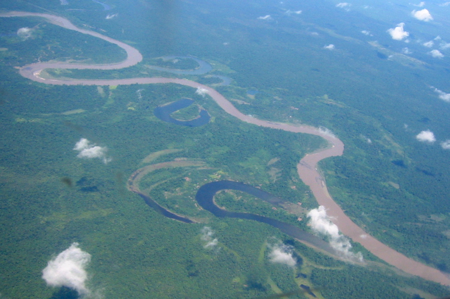 Part of the Ramu from the air | |
 Location of the Ramu River | |
| Location | |
| Country | Papua New Guinea |
| Region | Madang Province |
| Physical characteristics | |
| Source | |
| • location | Kratke Range, Papua New Guinea |
| Mouth | |
• location | Bismarck Sea, Papua New Guinea |
• coordinates | 4°1′S 144°40′E |
| Length | 640 km (400 mi) |
| Basin size | 18,720 km2 (7,230 sq mi) |
| Discharge | |
| • average | 1,500 m3/s (53,000 cu ft/s) |
| • maximum | 5,000 m3/s (180,000 cu ft/s) |
Along the Ramu's course, it receives numerous tributaries from the Bismarck Range to the south and the Finisterre and Adelbert.
History
For many millennia, people have lived along the river, and the river has formed the basis for food, transport, and culture.
German exploration
The area encompassed by the Ramu was part of Kaiser-Wilhelmsland when Germany established German New Guinea in 1884. The Germans were quick to explore their territory, and the mouth of the Ramu was discovered in 1886 by Vice-Admiral Freiherr von Schleinitz after returning to Finschhafen from an expedition to the nearby Sepik.[1] Schleinitz called the Ramu, Ottilien after his ship the Ottilie.[1]
The course of the river was first discovered 10 years later in 1896 after Dr Carl Lauterbach, a botanist, led an expedition organised by the German New Guinea Company (Neu Guinea Kompagnie) to find the headwaters of the Markham River.[2] After crossing the Ortzen Mountains from Astrolabe Bay south of Madang, Lauterbach's party, instead of finding the Markham, found an unknown river flowing northwest. The party canoed along a section before their supplies dwindled; they returned to the coast retracing their route.[2]
Another German explorer, Ernst Tappenbeck, who had accompanied Lauterbach previously, led the first expedition to ascend the Ramu in 1898. Tappenbeck was charged with discovering whether the Ottilien found in 1886 was the same river Lauterbech had found. He was accompanied by former Prussian Army officers, a Kompagnie official and an Australian gold prospector Robert Phillip, and travelled in the Neu Guinea Kompagnie steamer Herzog Johann Albrecht.[3]
After five days of journey up the Ramu, Tappenbeck left his companions at a well-stocked camp when river water levels fell. He returned four and half months later in another steamer, Herzogin Elisabeth, and the party managed to navigate 190 mi (310 km) upstream and go farther still by canoe.[3] By the end of 1898, the expedition had established a station on the river, mapped it and tributaries, and made a large botanical collection.[3]
Further explorations for gold and botanical specimens were conducted by the Germans. In 1902, Hans Klink and J. Schlenzig established a new Ramu station that was later connected by a bridle track to the coast.[4] Dr R. Schlecter led another expedition in 1902 in search of gutta-percha trees.[4] Then in 1907, Austrian explorer Wilhelm Dammköhler led an expedition up the Markham Valley and linked the headwaters of the Markham River with the Ramu for the first time.[4]
Australian administration and Second World War

After the First World War, German New Guinea passed over to Australian control and became the Territory of New Guinea. The Ramu reverted to its local name during this time.
In 1936, Briton, Lord Moyne, ventured up the Ramu during an expedition to Indonesia and New Guinea. Moyne discovered a race of pygmy-like people inhabiting the middle Ramu region 170 miles (270 km) from the mouth of the river in the Aiome foothills.[5]
During the Second World War, in 1942 the Japanese annexed the entire Territory of New Guinea from the Australians. Intense fighting occurred between the Imperial Japanese Army and the Australian and US Armies to recapture New Guinea. During the Finisterre Range campaign in 1943 and 1944, the Ramu valley became the scene of a major battle.
Hydroelectric plant
The Ramu flows into Yonki Dam, where it feeds the Ramu 1 power station.
A hydroelectric plant was under construction on the toe of the Yonki Dam, however construction is currently (May 2011) suspended.
Image gallery
 The last 300 or so kilometres of the Ramu as it winds towards the Bismarck
 Ramu and Sepik sediment plumes

References
- Souter (1963) p. 73
- Souter (1963) p. 77
- Souter (1963) p. 78
- Souter (1963) pp. 111-112
- Lord Moyne; Kathleen Haddon (Jul–Dec 1936). "The Pygmies of the Aiome Mountains, Mandated Territory of New Guinea". Journal of the Royal Anthropological Institute. Royal Anthropological Institute. 66: 269–290. doi:10.2307/2844082. JSTOR 2844082.
- Souter, Gavin (1963). New Guinea: The Last Unknown. Angus & Robertson. ISBN 0-207-94627-2.
| Authority control |
|
|---|
На других языках
[de] Ramu
Der Ramu ist ein Fluss im nördlichen Papua-Neuguinea.- [en] Ramu
[ru] Раму (река)
Раму (англ. Ramu River) — река на острове Новая Гвинея. Протекает по территории провинции Маданг государства Папуа — Новая Гвинея. Исток реки находится в горах Кратке. Впадает в море Бисмарка, в северо-восточной части острова, в 32 км к юго-востоку от устья реки Сепик. Общая длина Раму составляет около 640 км. Последние 100 км река течет почти прямо на север.Другой контент может иметь иную лицензию. Перед использованием материалов сайта WikiSort.org внимательно изучите правила лицензирования конкретных элементов наполнения сайта.
WikiSort.org - проект по пересортировке и дополнению контента Википедии