geo.wikisort.org - River
The Osage River is a 276-mile-long (444 km)[2] tributary of the Missouri River in central Missouri in the United States. The eighth-largest river in the state, it drains a mostly rural area of 15,300 square miles (40,000 km2). The watershed includes an area of east-central Kansas and a large portion of west-central and central Missouri, where it drains northwest areas of the Ozark Plateau.
This article needs additional citations for verification. (June 2011) |
| Osage River | |
|---|---|
 | |
 Map of the Osage River watershed showing the Niangua River | |
| Location | |
| Country | United States |
| State | Missouri Kansas |
| Region | Osage Plains, Ozarks |
| City | Warsaw, Lake Ozark, Tuscumbia, St. Thomas |
| Physical characteristics | |
| Source confluence | |
| • location | Vernon County, Missouri |
| • coordinates | 38°01′39″N 94°14′39″W |
| • elevation | 722 ft (220 m) |
| Mouth | Missouri River |
• location | Bonnots Mill, Missouri |
• coordinates | 38°35′49″N 91°56′43″W[1] |
• elevation | 518 ft (158 m) |
| Length | 276 mi (444 km) |
| Basin size | 15,300 sq mi (40,000 km2) |
| Discharge | |
| • location | near St. Thomas, MO |
| • average | 10,879 cu ft/s (308.1 m3/s) |
| • minimum | 640 cu ft/s (18 m3/s) |
| • maximum | 216,000 cu ft/s (6,100 m3/s) |
| Basin features | |
| Tributaries | |
| • left | Marais des Cygnes River, South Grand River |
| • right | Little Osage River, Clear Creek, Sac River, Pomme de Terre River, Niangua River |
| Watersheds | Osage-Missouri-Mississippi |
The river flows generally easterly, then northeasterly for the final 80 miles (130 km) where it joins the Missouri River. It is impounded in two major locations. Most of the river has been converted into a chain of two reservoirs, the Harry S. Truman Reservoir and the Lake of the Ozarks.
Description
The Osage is formed in southwestern Missouri, approximately 14 miles (23 km) northeast of Nevada on the Bates-Vernon County line, by the confluence of the Marais des Cygnes and Little Osage Rivers; the Marais des Cygnes is sometimes counted as part of the river, placing its headwaters in eastern Kansas and bringing its total length to over 500 miles (800 km). The combined stream flows east past the Schell-Osage Wildlife Area into St. Clair County, widening into a long meandering arm of the Harry S. Truman Reservoir, approximately 40 miles (64 km) long. The lake receives the South Grand River as a second arm of the reservoir from the northwest, as well as the Pomme de Terre River from the south. The two arms of the reservoir join near the Harry S. Truman Dam in central Benton County.
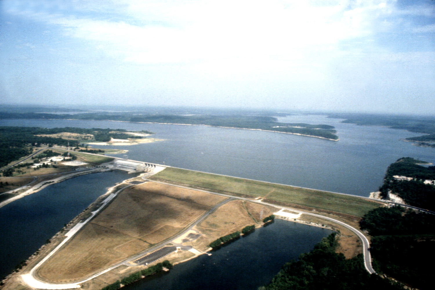
Downstream from the Truman Dam, the river becomes the serpentine Lake of the Ozarks, stretching eastward for nearly 92 miles (148 km) to Bagnell Dam in Camden County and southwestern Miller County. Constructed in 1931, the dam collects the Niangua River. Downstream from the dam, the Osage flows freely to the northeast in broad oxbow meanders through forested bluffs, joining the Missouri approximately 15 miles (24 km) east and downstream of Jefferson City.
History

The river is named for the Osage Nation,[3] the historic indigenous people who dominated this region at the time when the first European settlers arrived. The river presented significant navigation difficulties for early settlers because of its fluctuating water levels, as well as the presence of shallow pools and sand bars caused by its tight meandering course through the hills.
The Missouri Legislature attempted as early as 1839 to deepen the channel of the river. Early attempts failed because of lack of funding for the immense task. Commercial navigation on the river in the 19th century was confined mostly to smaller craft that could navigate the tight bends and shoals of the river. Improvements in the channel by the last two decades of the century led to greater commercial traffic. These changes made the lower reaches of the river navigable for steamboat commerce for a period of six to nine months out of the year.
In the 20th century, federal construction of the Bagnell Dam, primarily to generate hydroelectricity, began in 1922 and was completed after nine years. It effectively ended commercial navigation on the river. The Truman Dam was authorized by the federal Flood Control Act of 1954 and was completed in 1979.
The two dams on the river generate power for the St. Louis metropolitan area. The large reservoirs have become popular tourist destinations and recreation areas in the region.
See also
- List of Kansas rivers
- List of Missouri rivers
References
- "Osage River". Geographic Names Information System. United States Geological Survey. Retrieved 2015-12-04.
- U.S. Geological Survey. National Hydrography Dataset high-resolution flowline data. The National Map Archived 2012-03-29 at the Wayback Machine, accessed May 31, 2011
- "Cole County Place Names, 1928–1945 (archived)". The State Historical Society of Missouri. Archived from the original on 24 June 2016. Retrieved 22 September 2016.
{{cite web}}: CS1 maint: bot: original URL status unknown (link)
External links
- "Navigating the Osage River in Missouri: 1839-1926", hosted by Miller County Museum
| Authority control: National libraries |
|---|
На других языках
[de] Osage River
Der Osage River ist ein 444 km langer rechter Nebenfluss des Missouri River im US-Bundesstaat Missouri.[1] Der Osage River gehört zu den größten Flüssen in Missouri. Der Fluss entwässert hauptsächlich ländliche Gebiete. Das Einzugsgebiet beträgt 15.300 km² und umfasst Ost-Zentral-Kansas sowie einen großen Teil von West-Zentral-Missouri, wo er den nordwestlichen Teil des Ozark-Plateaus entwässert. Der Fluss fließt überwiegend in östlicher Richtung. Auf den letzten 80 km ändert er seine Fließrichtung nach Nordosten, bis er auf den Missouri River trifft. Ein großer Teil des Flusses wurde in eine Seenlandschaft umgewandelt – bestehend aus den beiden Stauseen Harry S. Truman Reservoir und Lake of the Ozarks.- [en] Osage River
[es] Río Osage
El río Osage (en inglés: Osage River) es un río del centro de los Estados Unidos, uno de los principales afluentes del río Misuri. Tiene una longitud de 579 km, pero con una de sus fuentes, el río Marais des Cygnes, llega hasta los 804 km (que lo sitúan entre los 50 ríos más largos de los Estados Unidos). Es también el mayor de los ríos que discurren íntegramente por el estado de Misuri, drenando una cuenca de 39.600 km² (mayor que países como Bélgica y Moldavia) en la parte central del estado, un área rural en el borde septentrional de las montañas Ozark.[it] Osage (fiume)
L'Osage è un fiume del Missouri negli Stati Uniti, affluente di destra del fiume Missouri, lungo 444 km (276 miglia).[ru] Осейдж (река)
Осейдж (англ. Osage River) — река в центральной части штата Миссури, США. Правый приток реки Миссури. Составляет 444 км в длину[2]; площадь бассейна — около 39 627 км². Средний расход воды в районе города Сент-Томас — 308 м³/с.Другой контент может иметь иную лицензию. Перед использованием материалов сайта WikiSort.org внимательно изучите правила лицензирования конкретных элементов наполнения сайта.
WikiSort.org - проект по пересортировке и дополнению контента Википедии