geo.wikisort.org - Reservoir
Lake of the Ozarks is a reservoir created by impounding the Osage River in the northern part of the Ozarks in central Missouri. Parts of three smaller tributaries to the Osage are included in the impoundment: the Niangua River, Grandglaize Creek, and Gravois Creek. The lake has a surface area of 54,000 acres (220 km2) and 1,150 miles (1,850 km) of shoreline. The main channel of the Osage Arm stretches 92 miles (148 km) from one end to the other. The total drainage area is over 14,000 square miles (36,000 km2). The lake's serpentine shape has earned it the nickname "The Missouri Dragon", which has in turn inspired the names of local institutions such as The Magic Dragon Street Meet.[5]
| Lake of the Ozarks | |
|---|---|
 Aerial panorama of Lake of the Ozarks | |
 Lake of the Ozarks  Lake of the Ozarks | |
| Location | Benton, Camden, Miller, and Morgan Counties in Missouri |
| Coordinates | 38°12′09″N 92°37′35″W |
| Type | Reservoir |
| Primary inflows | Grandglaize Creek, Gravois Creek, Niangua River, Osage River |
| Primary outflows | Osage River |
| Catchment area | 14,000 sq mi (36,300 km2) |
| Basin countries | United States |
| Managing agency | Ameren Missouri |
| Built | August 6, 1929 |
| First flooded | February 2, 1931 |
| Max. length | 93 miles (150 km)[1] |
| Surface area | 54,000 acres (220 km2)[2] |
| Max. depth | 130 ft (40 m)[3] |
| Water volume | 1,927,000 acre⋅ft (2.377×10⁹ m3)[1] |
| Residence time | 2-4 months |
| Shore length1 | 1,150 miles (1,850 km) |
| Surface elevation | 659 ft (201 m) |
| Settlements | Camdenton, Gravois Mills, Lake Ozark, Laurie, Osage Beach, Sunrise Beach, Village of Four Seasons |
| References | [2][3][4] |
| 1 Shore length is not a well-defined measure. | |
History

A hydroelectric power plant on the Osage River was first pursued by Kansas City developer Ralph Street in 1912. He put together the initial funding and began building roads, railroads, and infrastructure necessary to begin construction of a dam, with a plan to impound a much smaller lake. In the mid-1920s, Street's funding dried up, and he abandoned the effort.[6]
The lake was created by the construction of the 2,543-foot (775 m) long Bagnell Dam by the Union Electric Company of St. Louis, Missouri. The principal engineering firm was Stone and Webster. Construction began August 8, 1929, and was completed in April 1931; the lake reached spillway elevation on May 20, 1931.
During construction, the lake was referred to as Osage Reservoir or Lake Osage. The Missouri General Assembly officially named it Lake Benton after Senator Thomas Hart Benton. None of the names stuck, as it was popularly referred to by its location at the northern edge of the Ozarks. The electric generating station, however, is still referred to by the utility company as the "Osage Hydroelectric Plant."[7]
While some sources indicate that more than 20 towns, villages and settlements were permanently flooded to create the lake, research indicates that the actual number was closer to eight. Several other settlements had been previously abandoned, were relocated to make way for the lake, or were on high enough ground that the creation of the lake did not affect them.[8]
At the time of construction, Lake of the Ozarks was the largest man-made lake in the United States and one of the largest in the world. It was created to provide hydroelectric power for customers of Union Electric, but it quickly became a significant tourist destination. Most of its shoreline is privately owned, unlike many flood-control lakes in the region that were constructed by the U.S. Army Corps of Engineers. The relatively stable surface elevation has created conditions suitable for private development within a few feet of the shoreline. There are over 70,000 homes along the lake, many of which are vacation homes. The lake is now a major resort area, and more than 5 million people visit annually.[citation needed]
In 2011, the Federal Energy Regulatory Commission (FERC) renewed the lease for the power plant operated by Ameren Missouri. In the process, FERC determined that numerous homes and structures were encroaching on utility land in violation of federal regulations. According to the Boston Globe, this issue "has triggered panic in the area's lakefront communities and led to a growing battle among regulators, a utility company, land attorneys, and the state's congressional delegation."[9]
In 2015, FERC issued an order allowing Ameren Missouri to pursue permits for approximately 215 structures that were termed as "non-conforming." Those were the structures remaining in limbo after Ameren was given approval to redraw the project lines encompassing Lake of the Ozarks.[10]
Recently, the lake has been impacted by several extreme weather events. In 2019, the lake was impacted by the 2019 Midwest floods. In 2021, the lake froze over during a cold wave in February 2021, the first time the lake had frozen over in 20 years, according to Ameren Missouri.[11][12]
Geography
The Lake of the Ozarks is located within the Ozark Mountains with Bagnell Dam lying at an elevation of 659 feet (201 m).[4][13] It lies in central Missouri on the Salem Plateau of the Ozarks.[14] The lake extends across four Missouri counties, from Benton County in the west through Camden and Morgan counties to Miller County in the east.[15]
The reservoir is impounded at its northeastern end by Bagnell Dam, and the Osage River is both its primary inflow and outflow.[15] Long and winding in shape, the lake consists of the main, 93-mile-long (150 km) Osage River channel as well as several arms, each fed by a different tributary.[1][15] The southwestern arm is fed by the Niangua and Little Niangua rivers,[16] the southeastern arm by Grandglaize Creek,[17] and the northern arm by several streams including Gravois, Indian, and Little Gravois creeks.[18] Many smaller tributaries also drain into the lake, creating numerous small coves and indentations in its shore.[16][17][18] As a result, the lake has approximately 1,150 miles (1,850 km) of shoreline.[2]
U.S. Route 54 runs east–west across the reservoir's southwestern arm and then generally northeast–southwest along its eastern shoreline, crossing the southeastern arm at Osage Beach and crosses the Grand Glaize Bridge. Missouri Route 5 runs generally north–south along the lake's western shoreline, crossing the main channel at Hurricane Deck. Missouri Route 7 runs generally northwest–southeast to the lake's southwest, crossing the southwestern arm. Missouri Route 134 runs southeast from U.S. 54 north of Osage Beach to its southern terminus in Lake of the Ozarks State Park. Route 42 connects to Route 134 and US 54 in Osage Beach. Route 242 connects US 54 to near Village of Four Seasons. In addition, a network of supplemental state routes provides access to various points along the lake shore.[15]
Numerous settlements are located near or on the Lake of the Ozarks. With a population of 4,570, the largest city is Osage Beach which sits where the lake's southeastern arm joins the main channel. The second largest is the city of Camdenton, located a few miles east of the southwestern arm. Lake Ozark lies immediately north of Osage Beach and just south of Bagnell Dam. Other, smaller communities along or near the lake include (from east to west): Kaiser, Lakeside, Linn Creek, Village of Four Seasons, Rocky Mount, Sunrise Beach, Hurricane Deck, Gravois Mills, Laurie, and Lakeview Heights.[15]
Hydrography
The Lake of the Ozarks has a storage capacity of approximately 1,927,000 acre-feet (2.377×10⁹ m3).[1] When filled to that volume, it has a surface elevation of 660 feet (200 m) and occupies a surface area of approximately 54,000 acres (220 km2).[2][19] The lake rarely varies in surface elevation by more than 5 feet (1.5 m).[19] As it was constructed for power generation, not flood control, the lake has only limited flood control capacity.[1]
Due to its large volume and surface area, various sources identify the Lake of the Ozarks as either the largest reservoir in Missouri or the second-largest after Truman Reservoir.[20][21][22]
Infrastructure
Bridges and Dams
A large number of bridges have been constructed for efficient crossing of the lake.
Niangua Bridge - Built in 1936; replaced by a girder bridge in 2003.
Niangua Arm US 54 Bridge - Built in 1931; replaced by a girder bridge in 1999.
Hurricane Deck Bridge

The Hurricane Deck Bridge is a delta frame bridge located in the west side of Lake of the Ozarks. Stretching over 2,280.3 ft (695 m) long and 28.0 ft (9 m) wide, the bridge was established to connect Laurie with Camdenton. The bridge was originally constructed in 1934 as a truss arch bridge, however this bridge was replaced in 2013 with a delta frame bridge.[23] The first bridge's structure was similar to the structure of the I-35W Mississippi River bridge, which had collapsed six years before the bridge was destroyed. After the replacement opened in 2013, the original bridge was destroyed.[24]
Grand Glaize Bridge
Originally built in 1930, the bridge crosses the Grand Glaize Arm of the Lake of the Ozarks in Osage Beach, Missouri. The bridge carries U.S. Route 54 and connects Osage Beach to Camdenton. Originally one girder bridge carrying both directions of traffic, a second girder bridge was constructed in 1984, enabling traffic to pass over the lake in both directions using separate bridges. The bridge has undergone a significant number of improvements since its original construction, and now supports three lanes of traffic in both directions.
Bagnell Dam
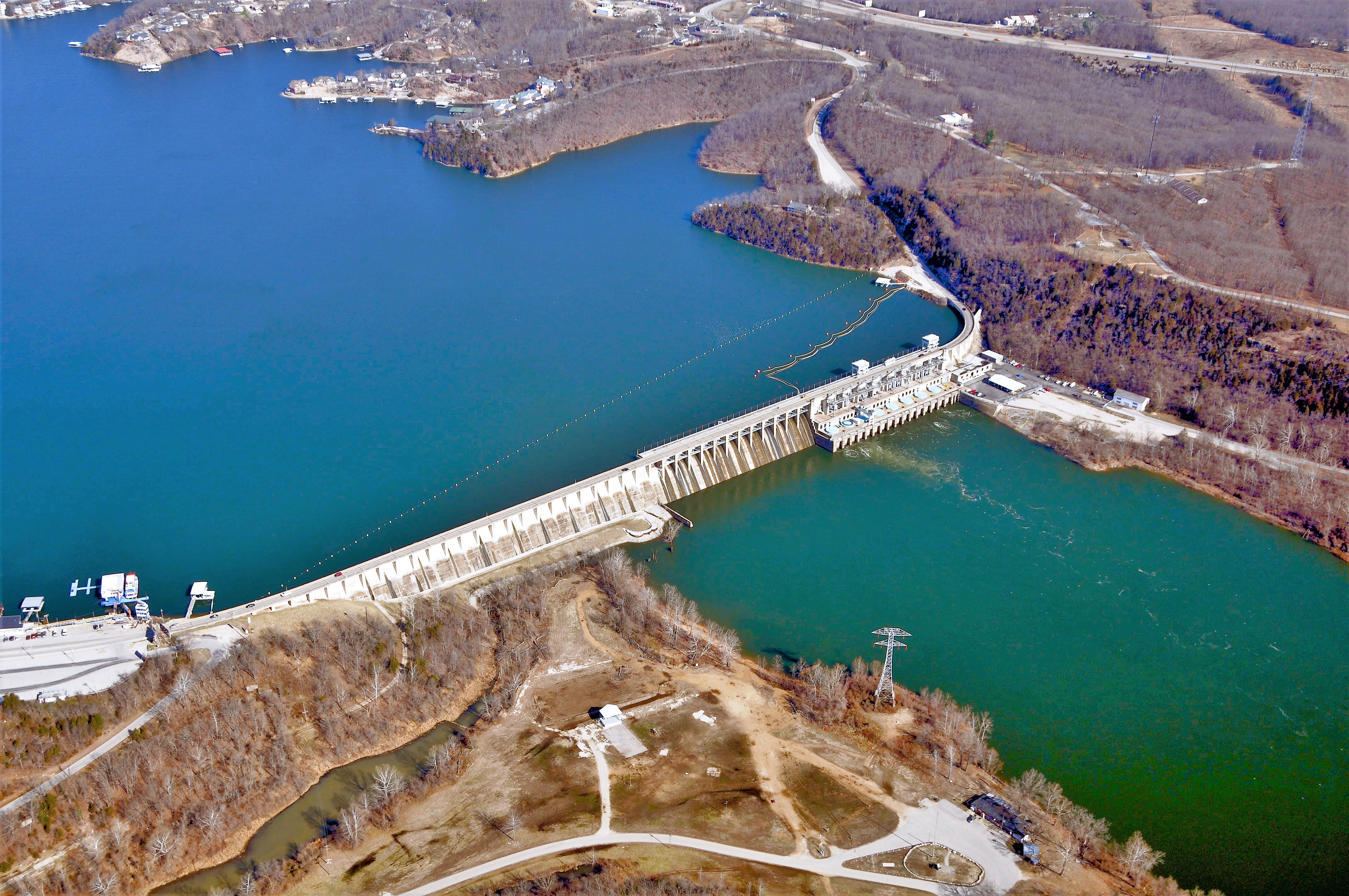
Originally constructed in 1931, Bagnell Dam is the only major dam supporting Lake of the Ozarks. Located in Miller County near Camden County, the dam is 2,543 feet (775 m) long and 148 feet (48 m) tall.[25] The dam was originally constructed by the Union Electric Company (now Ameren) to provide hydroelectric power to the nearby Osage Powerplant (located near the base of the dam) and support two-way traffic on a narrow highway above the dam (Bagnell Dam Boulevard). Since its original construction, the dam has undergone a number of significant infrastructure upgrades throughout the 2010s. The dam has 12 floodgates which fully opens when the lake floods. In 2019, the floodgates were open due to the Lake of the Ozarks being impacted by the floods.[26]
Lake of the Ozarks Community Bridge

The Lake of the Ozarks Community Bridge is a continuous truss bridge in Lake Ozark. The bridge is over 2,695 ft (821 m) long and 72 ft (22 m) wide.[27] Built in 1998, the bridge is one of the newest bridges in the Lake of the Ozarks area, primarily built to connect the east (towards Lake Ozark and Osage Beach) and west sides (towards Sunrise Beach and Camdenton) of Lake of the Ozarks. Furthermore, the bridge is the only toll bridge in the Lake of the Ozarks area, with a toll that varies between seasons. The bridge is expected to be toll-free by 2026.[28]
Management

Bagnell Dam is operated and maintained by Ameren Missouri, the successor of Union Electric, under the authority of a permit issued by the Federal Energy Regulatory Commission. Ameren Missouri is also responsible for managing both the shoreline and water levels of the lake. All land surrounding the lake that is within the project boundary defined by the FERC is under the company's jurisdiction. Any improvements to the shoreline including docks, seawalls, and other structures require permission from Ameren Missouri prior to construction.[29]
Tourism and recreation

During the process of land acquisition for the lake during the 1920s, 17,500 acres (71 km2) of land were set aside for a national park along the Grand Glaize Arm of the lake. In 1946, this land was acquired by the State of Missouri for Lake of the Ozarks State Park, the largest State Park in Missouri. Another state park on the shores of the lake is Ha Ha Tonka State Park on the Niangua Arm of the lake.
Lake of the Ozarks State Park is home to Party Cove, a gathering spot that a New York Times writer called the "oldest established permanent floating bacchanal in the country."[30] The Missouri State Water Patrol has estimated that the cove attracts up to 3,000 boats during the Fourth of July weekend.[30]
During the 2020 COVID-19 pandemic the Lake of the Ozarks gained notoriety when on Memorial Day (May 25, 2020) a large crowd congregated at the lake.[31][32]
On April 1st, 2012, Biologist and TV Personality Jeremy Wade visited the lake and filmed an episode on the large catfish that could be caught there.[33]
In 2021, it was announced that Osage Casino is planned to be built in the Lake of the Ozarks area.[34] It has not been announced construction will begin although in April 2022, demolition of the former Quality Inn was completed where the casino will be located.[35]
Events
This section does not cite any sources. (August 2021) |
AquaPolooza takes place each July. Attendees gather on rafts and inflatable tubes. Live music is usually played from noon to 5pm as boaters link up their boats to one another.[citation needed]
At the end of every summer, the Lake of the Ozarks holds an event called "The Shootout". It is the biggest powerboat racing event of the year at the lake and runs over a three-mile course.
On the last Saturday of February of every year, the Lake of the Ozarks holds a Polar bear plunge event. The event is a fundraiser for Special Olympics in Missouri.
In popular media
The TV series Ozark is set in Osage Beach though filmed in the state of Georgia. In November 2017, it was reported that the series helped increase tourism and notoriety of the Lake of the Ozarks, but did not have a significant economic impact.[36] In February 2018, a real life restaurant called "Marty Byrde's", inspired by the series, was opened in Lake Ozark, Missouri, and includes menu items based on the show, including "Ruth's Smoked Wings".[37]
References
- "Hydrology". Missouri Department of Conservation. Archived from the original on 2016-01-31. Retrieved 2015-12-02.
- Great Osage River Project from the website of the Lake of the Ozarks Convention & Visitor Bureau
- "Midwest Diving Locations". Columbus Sea Nags Scuba Diving Club. Retrieved 2007-07-14.
- "Lake of the Ozarks". Geographic Names Information System. United States Geological Survey, United States Department of the Interior. Retrieved 2015-12-02.
- "Magic Dragon Street Meet Lake of the Ozarks : Car Show Lake of the Ozarks MO". Lake Area Chamber of Commerce. Archived from the original on 2011-07-15. Retrieved 2011-07-24.
- "Lake of the Ozarks - Lake Ozark, MO". www.lakeozark.com. Archived from the original on 2008-05-09.
- "Lake of the Ozarks Name". www.lakehistory.info.
- Gillespie, Michael (2008). "The Myth of the Sunken Townsites". lakehistory.info. Lone Jack, MO: The Lake Area History Pages!. Retrieved August 15, 2018.
- Blank, Chris (2011), "Mo. residents upset by order to move lake homes", Boston.com, retrieved 2011-11-07
- "FERC accepts shoreline structures". Lake News Online. 2014-03-06. Retrieved 2020-12-19.
- Bechtold, Nathan. "DOCK ICE: Lake Of The Ozarks Is Freezing Over, Here's How To Protect Your Dock & Boat". LakeExpo.com. Retrieved 2022-03-31.
- Reporter, Sydney Moran, KOMU 8. "Ice damages docks at Lake of the Ozarks". KOMU 8. Retrieved 2022-11-14.
- Lake Ozark, MO, 7.5 Minute Topographic Quadrangle, USGS, 1959 (1981 rev.)
- "Physiographic Regions of Missouri [Map]" (PDF). Missouri Department of Natural Resources. 2002. Retrieved 2015-12-02.
- "Missouri Highway Map" (PDF). Missouri Department of Transportation. 2013. Retrieved 2015-12-02.
- "General Highway Map - Camden County" (PDF). Missouri Department of Transportation. June 2011. Retrieved 2015-12-02.
- "General Highway Map - Miller County" (PDF). Missouri Department of Transportation. October 2011. Retrieved 2015-12-02.
- "General Highway Map - Morgan County" (PDF). Missouri Department of Transportation. December 2011. Retrieved 2015-12-02.
- "Lake Ozark Guide Curve - 2015". Ameren Missouri. Retrieved 2015-12-03.
- Foley, William E.; McCandless, Perry (2001). Missouri Then and Now. Columbia, MO: University of Missouri Press. p. 37.
- Keefer, Greg (2011-08-31). "10 Great Missouri Bass Lakes". Game & Fish. Retrieved 2015-12-03.
- "Lakes in Missouri, United States". Lakes Online. Retrieved 2015-12-03.
- "Archived copy" (PDF). Archived from the original (PDF) on 2011-12-23. Retrieved 2012-10-16.
{{cite web}}: CS1 maint: archived copy as title (link) - LakeExpo.com. "PHOTOS: Hurricane Deck Bridge Demolition". LakeExpo.com. Retrieved 2021-09-20.
- "Bagnell Dam Facts and Figures". Lake Area History Pages.
- "Bagnell Dam Floodgates Open, Possibly For Weeks". LakeExpo.com. Retrieved 2022-11-10.
- "Lake of the Ozarks Community Bridge, Missouri | FHWA - Center for Innovative Finance Support - Project Profiles". www.fhwa.dot.gov. Retrieved 2022-10-28.
- Bechtold, Ariel Thibodeau & Nathan. "Lake Of The Ozarks' Toll Bridge Could Be Free By 2026". LakeExpo.com. Retrieved 2022-11-05.
- "Shoreline Management". Ameren Missouri. Retrieved 2015-12-18.
- Party Cove: Wild in the Ozarks, a July 2005 article from The New York Times
- "Memorial Day weekend crowds at Lake of the Ozarks appear to not be observing social distancing". 24 May 2020.
- "Crowd ignores social distancing in Missouri's Lake of the Ozarks - The Washington Post".
- "Jeremy Wade Goes in Search of 'Catfish Big Enough to Swallow a Man' – Discovery, Inc". corporate.discovery.com. Retrieved 2022-10-14.
- Schneider, Joey. "Osage Nation of Oklahoma announces plans to build casino in Lake of the Ozarks region". https://www.ky3.com. Retrieved 2022-11-14.
{{cite web}}: External link in|website= - "Osage Nation launches website for updates on Lake of the Ozarks gaming plans". Osage News. 2022-06-23. Retrieved 2022-11-14.
- Keegan, Harrison (November 23, 2017). "Netflix show 'Ozark' brings notoriety, but not much business to Lake of the Ozarks resort". Springfield News-Leader. Archived from the original on November 17, 2020. Retrieved July 30, 2020.
- Havranek, Andrew (February 18, 2018). "New restaurant inspired by Netflix's "Ozark" to open in Lake Ozark". KY3. Archived from the original on November 17, 2020. Retrieved July 30, 2020.
-
"Lake Ozark FPD Launches New Fire Boat". KRMS. 2018-11-27. Archived from the original on 2018-11-28.
The new boat cost roughly $500,000. The older boat will remain on the water, too. It will be sold to Mid-County Fire Protection District.
External links
 Lake of the Ozarks travel guide from Wikivoyage
- Lake of the Ozarks, Ameren Missouri
- Lake of the Ozarks, Lake of the Ozarks Convention & Visitor Bureau
- Ha Ha Tonka State Park, Missouri Department of Natural Resources
- Lake of the Ozarks State Park, Missouri Department of Natural Resources
- Lake of the Ozarks Discord Chat, Lake of the Ozarks Discord Chat
- Lake of the Ozarks bridges, bridge hunter
На других языках
[de] Lake of the Ozarks
Der Lake of the Ozarks (Ozarks-See) ist ein Stausee am Osage River im Miller County in Missouri. Er wurde gebaut, um Strom zu erzeugen, und hat heute hohe touristische Bedeutung.- [en] Lake of the Ozarks
[fr] Lac des Ozarks
Le lac des Ozarks est un grand réservoir créé par la retenue de la rivière Osage dans la partie nord des monts Ozarks, dans le centre de l'État américain du Missouri.Другой контент может иметь иную лицензию. Перед использованием материалов сайта WikiSort.org внимательно изучите правила лицензирования конкретных элементов наполнения сайта.
WikiSort.org - проект по пересортировке и дополнению контента Википедии