geo.wikisort.org - River
The Meta River is a major left tributary of the Orinoco River in eastern Colombia and southern Venezuela, South America. The Meta originates in the Eastern Ranges of the Andes and flows through the Meta Department, Colombia as the confluence of the Humea, Guatiquía and Guayuriba rivers. It flows east-northeastward across the Llanos Orientales ("Eastern Plains") of Colombia following the direction of the Meta Fault.[3] The Meta forms the northern boundary of Vichada Department, first with Casanare Department, then with Arauca Department, and finally with Venezuela, down to Puerto Carreño where it flows into the Orinoco.
This article needs additional citations for verification. (May 2014) |
| Meta River | |
|---|---|
 Ferry over the Rio Meta on the road from Puerto Ayacucho to San Fernando de Apure in Venezuela | |
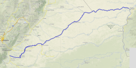 Course of the Río Meta. | |
 | |
| Location | |
| Country | Colombia Venezuela |
| Physical characteristics | |
| Source | |
| • location | Colombia |
| • elevation | c. 1,300 m (4,300 ft) |
| Mouth | |
• location | Orinoco at Puerto Carreño |
• coordinates | 6.19517°N 67.4564°W |
| Length | 1,100 km (680 mi) |
| Basin size | 103,000 km2 (40,000 sq mi)[1] to 106,733 km2 (41,210 sq mi)[2] |
| Discharge | |
| • average | (Period of data: 1926-2011)5,694 m3/s (201,100 cu ft/s)[1] to 5,899 m3/s (208,300 cu ft/s)[2] |

The Meta River is 1,100 km (680 mi) long and its drainage basin is 103,000 km2 (40,000 sq mi). The Meta divides the Colombian Llanos in two different parts: the western portion on the left bank is more humid, receives the relatively nutrient-rich sediments from the Andean mountain range and therefore soils and tributaries are also nutrient-rich, while the eastern portion, high plain or altillanura, drains not to the Meta river but to the Orinoco, has a longer dry season and soils and surface waters are oligotrophic (nutrient poor).
The major tributaries of the Meta are the Cravo Sur, the Casanare, the Cusiana, the Upía and the Manacacías rivers.
History
In 1531, while exploring the Orinoco river, Diego de Ordáz became the first European to discover the estuarine delta of the Meta. Following indications of a gold country at the headwaters of the river - the "Meta Province" - he and his companions navigated the Meta upstream for 50 days until,[4] due to the seasonally low water level, they could make no further progress and had to turn back without having achieved anything. The first Europeans to reach the headwaters of the Meta at the foot of the Eastern Cordillera were the participants of an expedition led by the conquistador Georg Hohermuth von Speyer in 1536.[5]
An 1856 watercolor by Manuel María Paz, of three indigenous people with a boat at Orocué, near the Old Macuco Mission, is an early depiction of life on the river.[6]
Indigenous groups
Living along the Meta are various indigenous groups. In the upper part of the river, close to the foothills of the Eastern Ranges and farther downstream, the Guayupe, Achagua, Sáliva and Guahibo people are living.[3]
Economy
Starting at Puerto López the Meta becomes navigable, and thus is an important component of the trade across the Colombian and Venezuelan Llanos.
References
- José Rafael, Córdova; Marcelo González, Sanabria. "La geografía del agua" (PDF).
- Félix Dario, Sánchez; Martha, García; Omar, Jaramillo; Nelsy, Verdugo (2010). "Estudio Nacional del Agua 2010".
- (in Spanish) Indígenas de los Llanos Orientales - Banco de la República
- Gonzalo Fernández de Oviedo y Valdés (1959). Historia General y Natural de las Indias, Vol II. Madrid. pp. 389 ff.
- Juan de Castellanos (1997). Elegías de varones ilustres de Indias. Bogotá. pp. 410 ff.
- Paz, Manuel María. "View of the River Meta from Orocué, near the Old Macuco Mission, Province of Casanare". World Digital Library. Retrieved 2014-05-21.
Tributaries of the Orinoco | ||
|---|---|---|
| From the Guiana Highlands |  | |
| From elsewhere | ||
| Authority control |
|
|---|
На других языках
[de] Río Meta
Der Río Meta ist mit einem mittleren Abfluss von rund 4300 m³/s der drittgrößte Nebenfluss des südamerikanischen Stromes Orinoco und fließt durch die östlichen Llanos von Kolumbien. Er ist 1200 Kilometer lang und auf ca. 900 Kilometern ab Puerto López für den Schiffsverkehr freigegeben. Dieser Fluss ist damit ein wichtiger Handelsweg zwischen Kolumbien und Venezuela.- [en] Meta River
[es] Río Meta
El río Meta es un largo río de la Orinoquia colombiana, uno de los grandes afluentes del río Orinoco, que discurre por territorio colombiano y forma en su tramo final frontera con Venezuela a lo largo de unos 220 km.[1] Tiene una longitud de 804 km, aunque con sus fuentes supera los 1000 km, de los que 785 son navegables.[it] Meta (fiume Colombia)
Il Meta è un fiume del Sud America, principale affluente colombiano del fiume Orinoco.[ru] Мета (река)
Ме́та (исп. Río Meta) — река в Колумбии и Венесуэле, левый приток реки Ориноко. В нижнем течении служит границей между этими странами. Длина реки составляет 1000 км, площадь бассейна — 112 000 км². Судоходный участок — 785 км[1].Другой контент может иметь иную лицензию. Перед использованием материалов сайта WikiSort.org внимательно изучите правила лицензирования конкретных элементов наполнения сайта.
WikiSort.org - проект по пересортировке и дополнению контента Википедии