geo.wikisort.org - River
The Mareb River, or Gash River (Arabic: القاش) is a river flowing out of central Eritrea. Its chief importance is defining part of the boundary between Eritrea and Ethiopia, between the point where the Mai Ambassa enters the river at 14°53.6′N 37°54.8′E to the confluence of the Balasa with the Mareb at 14°38′N 39°1.3′E.[1]
| Mareb River Gash or al-Qash | |
|---|---|
 The dry river at Kassala | |
 The Mareb River in the Atbara basin | |
| Location | |
| Countries |
|
| Physical characteristics | |
| Source | |
| • location | 15 kilometres (9.3 mi) south-west Asmara |
| Mouth | |
• location | dissipate in the sands of the eastern Sudanese plains |
| Length | 440 km (270 mi) |
| Basin size | 31,000 km2 (12,000 sq mi) |
| Discharge | |
| • average | 21.6 m3/s (760 cu ft/s) |
| Basin features | |
| Tributaries | |
| • left | Sarana River, Balasa River, 'Engweya River, Gala River |
| • right | Obel River |
Course
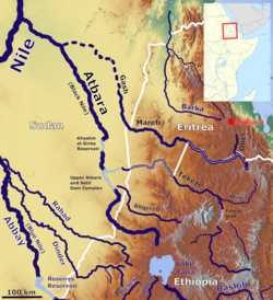
According to the Statistical Abstract of Ethiopia for 1967/68, the Mereb River is 440 kilometres (270 mi) long. The Ethiopian Ministry of Water Resources reports its Ethiopian catchment area as 5,700 square kilometres (2,200 sq mi), with an annual runoff of 0.26 billion cubic meters.[2] Other sources talking about a catchment of 21,000 square kilometres (8,100 sq mi) to 44,000 square kilometres (17,000 sq mi) over all, and a discharge of 21.6 cubic metres per second (760 cu ft/s) in average over the year, and 870 cubic metres per second (31,000 cu ft/s) in peaks.[3] Its headwaters rise south-west of Asmara in central Eritrea. It flows south, bordering Ethiopia, then west through western Eritrea to reach the Sudanese plains near Kassala. Unlike the Setit or Takazze rivers, which flow out of Ethiopia and also forms a natural border with Eritrea, the waters of the Mareb do usually not reach the Nile[4] but dissipate in the sands of the eastern Sudanese plains.
The Mareb is dry for much of the year, but like the Takazze is subject to sudden floods during the rainy season; only the left bank of the upper course of the Mareb is in Ethiopian territory. Its main tributaries are the Obel River on the right bank (in Eritrea) and the Sarana, Balasa, Mai Shawesh, and 'Engweya Rivers on the left (in Ethiopia).
History
The Mareb was important historically as the boundary between two separately governed regions in the area: the land of the Bahr negash (Tigrinya "kingdom of the sea", also known as Medri Bahri or "land of/by the sea") to the north of the river, and the Tigray to the south. The territories under the Bahr negash extended as far north as the Red Sea coast, and as far south (and west) as Shire[5] and the capital was at Debarwa in modern Eritrea, about 20 miles (30 km) south of Asmara.
Wildlife
The river's Eritrean floodplain was the location of a 2001 sighting of a sizable elephant herd, the first such sighting in Eritrea since 1955.[6]
See also
References
- Eritrea - Ethiopia Boundary Commission Decision Regarding Delimitation of the Border..., pp. 97, 102
- "Water Sector Development Program (Vol.2)" Archived 2011-07-20 at the Wayback Machine Ministry of Water Resources (accessed 21 January 2009)
- ENVIRONMENTAL IMPACT ASSESSMENT KASSALA Archived 2013-10-02 at the Wayback Machine
- Adequacy of satellite derived rainfall data for stream flow modeling Archived 2013-10-02 at the Wayback Machine
- Daniel Kendie, The Five Dimensions of the Eritrean Conflict 1941 – 2004: Deciphering the Geo-Political Puzzle (United States of America: Signature Book Printing, 2005), pp. 17-8.
- BBC Wildlife magazine, July 2003, retrieved at on 28 Sept 2007
На других языках
[de] Mareb
Der Mareb (so die europäische Schreibung, eigentlich Märäb; im Tiefland Gash bzw. auf Arabisch al-Qash (القاش) genannt) ist der nördlichste der nach Nordwesten fließenden Flüsse im Hochland von Abessinien. Er ist saisonal und bildet einen Teil der Grenze Äthiopiens zu Eritrea.- [en] Mareb River
[es] Río Mareb
El río Mareb, o río Gash (en árabe, القاش), es un importante río estacional del África Oriental, que nace en el centro de Eritrea y tras marcar su curso parte de la frontera entre Eritrea y Etiopía —entre el punto en el que recibe al Mai Ambassa hasta la confluencia del Balasa[1]—, acaba desapareciendo en las arenas de las llanuras orientales sudanesas. El río se seca gran parte del año, siendo visible de junio a septiembre, y en temporadas de lluvias excepcionales, puede llegar a alcanzar al Nilo.[it] Mareb
Il Mareb è un fiume dell'Africa Orientale. Il suo corso è di 680 km che sono in gran parte (520 km) compresi nei confini dell'Eritrea, avendo in essa le sue sorgenti e terminando il suo corso nella pianura a nord di Cassala nel Sudan. Il fiume è asciutto per la maggior parte dell'anno su buona parte del suo corso; come il Tacazzè, subisce repentine salite delle acque durante la stagione delle piogge.[ru] Мэрэб
Мэ́рэб (Гаш, англ. Mereb, Mareb, Gash, Mereb-Gash) — сезонная пересыхающая река, берущая начало в центральной Эритрее.Другой контент может иметь иную лицензию. Перед использованием материалов сайта WikiSort.org внимательно изучите правила лицензирования конкретных элементов наполнения сайта.
WikiSort.org - проект по пересортировке и дополнению контента Википедии