geo.wikisort.org - River
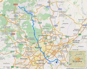
The Manzanares (Spanish pronunciation: [manθaˈnaɾes]) is a river in the centre of the Iberian Peninsula, which flows from the Sierra de Guadarrama, passes through Madrid, and eventually empties into the Jarama river, which in turn is a right-bank tributary to the Tagus.
This article needs additional citations for verification. (December 2009) |
This article may be expanded with text translated from the corresponding article in Spanish. (December 2009) Click [show] for important translation instructions.
|
| Manzanares | |
|---|---|
 The Manzanares through El Pardo | |
 The Manzanares river | |
| Location | |
| Country | Spain |
| Region | Iberian Peninsula |
| Physical characteristics | |
| Source | Confluence of Arroyo de la Condesa and Arroyo de Valdemartín |
| • location | Manzanares el Real |
| • coordinates | 40°46′28″N 3°57′20″W |
| • elevation | c. 1,810 m (5,940 ft) |
| Mouth | Jarama river |
• location | Rivas Vaciamadrid |
• coordinates | 40°18′13″N 3°32′23″W |
• elevation | 533 m (1,749 ft) |
| Length | 92 km (57 mi) |
| Discharge | |
| • average | 10–15 m3/s (350–530 cu ft/s) |
| Basin features | |
| Progression | Jarama→ Tagus→ Atlantic Ocean |
In its urban section, the Manzanares River was modified to create a section of water several meters deep, in some parts navigable by canoes. This project of channeling and damming has been partially reversed in a re-naturalization project.
Course
Sources

The Manzanares has its sources in the southern slope of the Cuerda Larga, a branch of the Sierra de Guadarrama (the main eastern section of the Sistema Central), in the municipality of Manzanares el Real, in the Madrid region.
It is formally called Manzanares after the confluence of the arroyo de la Condesa and the Arroyo de Valdemartín.[1]
The Arroyo de la Condesa is in turn born in the ventisquero de la Condesa, a traditionally resilient snowdrift, and its watershed comprises the slopes in between La Maliciosa (2,227 m), the Alto de las Guarramillas—aka the Bola del Mundo (2,258 m)—and the Alto de Valdemartín (2,282 m).[2]
The Arroyo de Valdemartín's watershed spans from the Alto de Valdemartín to the Cabeza de Hierro Menor (2,373 m).[2]
Upper course

The upper river basin is protected as the Parque Regional de la Cuenca Alta del Manzanares, a nature reserve which is recognised as a biosphere reserve by UNESCO.
The Manzanares flows in a south-eastern direction from its sources, and passes through the medieval town of Manzanares el Real where it is dammed to form the Santillana reservoir, one of the most important water supplies for the capital.
The river then takes a southern direction and enters the Monte de El Pardo, an ecologically valuable area on the edge of Madrid.
Urban course

The river was canalised where it passes through the built-up areas of the city. In the 21st century the river was restored to provide biodiversity and facilities for Madrid residents.
The Manzanares skims past the westernmost part of the city and further downstream serves as a dividing line between the old centre of the city and the Carabanchel and Usera neighbourhoods to the southwest. It is along this stretch that it passes next to Atlético Madrid's former football ground, the Vicente Calderón. The river leaves the city at its southernmost tip.
Lower course

It makes a strong eastern turn which takes it past the village of Perales del Río. It empties into the Jarama within the municipal limits of Rivas Vaciamadrid.[3]
Historical importance

The river Manzanares, although small and relatively unimportant geographically, has had a great historical importance due to its close relation to the city of Madrid, which was founded by the Moors as a citadel overlooking the river in the ninth century.
The river is also featured in many paintings of the late 18th to early 19th-century painter Francisco de Goya, which show traditionally dressed Madrileños in activities like dancing or having picnics next to the river.
The Manzanares was also an important defence line for the Republican forces during the Siege of Madrid in the Spanish Civil War, and many bunkers can still be seen near the village of Perales del Río. The Bridge of the French was of crucial importance because of its strategic location. There, nationalist forces were repeatedly repelled and denied access to Madrid’s city centre.[4]
See also
- List of rivers of Spain
- Praga Bridge
- Puente de Segovia
- Arganzuela Footbridge
- Bridge of Toledo
References
- Citations
- Andrés de Pablo & Palacios Estremera 2004, pp. 85, 87–88.
- Andrés de Pablo & Palacios Estremera 2004, pp. 87–88.
- Lambertucci, Constanza (7 July 2019). "Excursión al nuevo Manzanares, el legado verde de Carmena". eldiario.es.
- See: Coronel Carlos Romero Giménez
- Bibliography
- Andrés de Pablo, N.; Palacios Estremera, David (2004). "Interrelación nieve/geomorfología en la Sierra de Guadarrama: altas cuencas del Ventisquero de La Condesa y Valdemartín". Cuadernos de Investigación Geográfica (30): 85–116. doi:10.18172/cig.1136. ISSN 0211-6820.
Authority control | |
|---|---|
| General |
|
| National libraries | |
На других языках
[de] Manzanares (Jarama)
Der Manzanares ist ein Fluss in Zentralspanien. Er ist 92 km lang und durchfließt die Hauptstadt Madrid, bevor er in den Jarama mündet. Der Fluss entspringt im Schneefeld Ventisquero de la Condesa in der Nähe des Navacerrada-Passes in der Sierra de Guadarrama.- [en] Manzanares (river)
[es] Río Manzanares
El Manzanares es un río del centro de la península ibérica, afluente por la derecha del Jarama, que a su vez es tributario del Tajo. Este río, que discurre íntegramente por la Comunidad de Madrid (España), nace en la sierra de Guadarrama, en el Ventisquero de la Condesa —la ladera meridional de la Cuerda Larga, cerca de la Bola del Mundo— y pasa por la ciudad de Madrid. Desemboca en el río Jarama, en el término municipal de Rivas-Vaciamadrid, después de un recorrido de 92 kilómetros.[it] Manzanarre
Il Manzanarre (AFI: /manʣaˈnarre/[1]; in spagnolo Manzanares) è un fiume spagnolo che nel suo corso attraversa la capitale Madrid.[ru] Мансанарес (река)
Мансана́рес (исп. Río Manzanares) — река в центральной части Испании, берёт начало в Сьерре-де-Гвадаррама, приток реки Харама. Протекает через город Мадрид. Даёт название, в частности, комарке Куэнка-Альта-дель-Мансанарес.Другой контент может иметь иную лицензию. Перед использованием материалов сайта WikiSort.org внимательно изучите правила лицензирования конкретных элементов наполнения сайта.
WikiSort.org - проект по пересортировке и дополнению контента Википедии