geo.wikisort.org - River
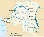
The Lulonga is a river in the Equateur province of Democratic Republic of the Congo. It is about 200 km long from its beginning at the town of Basankusu. The Lopori and the Maringa join to form the Lulonga there. The Lulonga River flows into the Congo River at the village of Lulonga.[2]
| Lulonga River | |
|---|---|
 The Lulonga River at the port of Basankusu | |
| Location | |
| Country | Democratic Republic of the Congo |
| Physical characteristics | |
| Mouth | |
• location | Congo River |
| Length | 200 km (120 mi) |
| Basin size | 76,950 km2 (29,710 sq mi) |
| Discharge | |
| • location | Confluence of Congo (near mouth) |
| • average | 2,040 m3/s (72,000 cu ft/s)[1] |
| Basin features | |
| Tributaries | |
| • left | Maringa |
| • right | Lopori |
References
- https://www.researchgate.net/publication/230601670.
{{cite web}}: Missing or empty|title=(help) - Jef Dupain; Janet Nackoney; Jean-Paul Kibambe; Didier Bokelo & David Williams. "Maringa-Lopori-Wamba Landscape" (PDF). L'Observatoire des Forêts d'Afrique Centrale. Retrieved 2011-10-14.
На других языках
- [en] Lulonga River
[it] Lulonga
Il Lulonga è un fiume della Repubblica Democratica del Congo che si trova nella regione nord-occidentale del Paese. Il suo corso, lungo circa 200 km, va dalla città di Basankusu fino alla sua affluenza nel Congo. Come tributari ha il Maringa e il Lopori.[ru] Лулонга
Лулонга — река в Экваториальной провинции Демократической Республики Конго. Является левым притоком реки Конго. Длина — 180[1] км. Площадь водосборного бассейна около 77 000[1] км².Текст в блоке "Читать" взят с сайта "Википедия" и доступен по лицензии Creative Commons Attribution-ShareAlike; в отдельных случаях могут действовать дополнительные условия.
Другой контент может иметь иную лицензию. Перед использованием материалов сайта WikiSort.org внимательно изучите правила лицензирования конкретных элементов наполнения сайта.
Другой контент может иметь иную лицензию. Перед использованием материалов сайта WikiSort.org внимательно изучите правила лицензирования конкретных элементов наполнения сайта.
2019-2025
WikiSort.org - проект по пересортировке и дополнению контента Википедии
WikiSort.org - проект по пересортировке и дополнению контента Википедии
