geo.wikisort.org - River
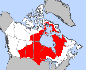
This list of Hudson Bay rivers includes the principal rivers draining into the Hudson, James and Ungava bays of the Arctic Ocean. The total surface area of the Hudson Bay watershed is about 3,861,400 square kilometres (1,490,900 sq mi),[1] with a mean discharge of about 30,900 m3/s (1,090,000 cu ft/s). The Hudson Bay drainage basin includes parts of five Canadian provinces (Alberta, Saskatchewan, Manitoba, Ontario, and Quebec), two territories (Northwest Territories and Nunavut), and four US states (Montana, South Dakota, North Dakota, and Minnesota). The two principal waterways are the La Grande Rivière, in Quebec, and the Nelson River in Manitoba, each with an average waterflow of over 3,000 m3/s (110,000 cu ft/s).
This article includes a list of general references, but it lacks sufficient corresponding inline citations. (May 2021) |
The rivers are presented by coastline, clockwise, starting with the George River in north-eastern Quebec, just south of Cape Chidley and the entrance to the Atlantic Ocean.
Rivers in Quebec
- George River
- Tunulic
- À la Baleine
- False
- Koksoak
- Aux Feuilles
- Arnaud
- Kovik River
- Povungnituk River
- Kogaluc
- Innuksuac
- Qikirtaluup Kuunga
- Nastapoka
- Chenal Goulet
- Petite Rivière de la Baleine
- Grande Rivière de la Baleine
- Roggan River
- La Grande
- Eastmain
- Pontax
- Rupert
- Broadback
- Nottaway
- Harricana
Rivers in Ontario
Rivers in Manitoba
- Hayes
- Nelson
- Churchill
- North & South Knife
- Red River of the North
- Seal
- Caribou
Rivers in Nunavut
- Geillini
- Thlewiaza
- Tha-anne
- Ferguson
- Wilson
- Chesterfield Inlet
- Lorillard
- Brown
- Kirchoffer (Southampton Island)
- Koukdjuak River (Baffin Island)
Rivers in Alberta
- North Saskatchewan
- Battle
- Beaver
- South Saskatchewan
- Bow
- Elbow
- Highwood
- Oldman
- St. Mary
- Red Deer
Rivers in the United States
- Bois de Sioux River
- Buffalo River (Minnesota)
- Marsh River (Minnesota)
- Red River of the North
- Sand Hill River
- Souris River
- Turtle River (North Dakota)
See also
- James Bay Project
- Nelson River Hydroelectric Project
- Rupert's Land
References
- "Canada Drainage Basins". The National Atlas of Canada, 5th edition. Natural Resources Canada. 1985. Archived from the original on 4 March 2011. Retrieved 24 November 2010.
- Stephen J. Déry et al., Characteristics and Trends of River Discharge into Hudson, James and Ungava Bays, 1964-2000, Journal of Climate, 18 (2005), pages 2540-2557.
- Water Resources of Canada (Website of Environment Canada)
На других языках
- [en] List of Hudson Bay rivers
[es] Cuenca vertiente de la bahía de Hudson
La cuenca vertiente de la bahía de Hudson es la cuenca hidrográfica de todos los ríos y lagos de Norteamérica que desembocan en las bahías de Hudson, James y Ungava, consideradas parte del océano Ártico. La superficie total de la cuenca de la bahía de Hudson es de aproximadamente 3.900.000 km², con un caudal medio de unos 30.900 m³/s. La cuenca de drenaje incluye partes de las cinco provincias de Canadá (Alberta, Saskatchewan, Manitoba, Ontario y Quebec), de los dos territorios de Canadá (Territorios del Noroeste y Nunavut) y de cuatro de los estados de EE.UU. (Montana, Dakota del Sur, Dakota del Norte y Minnesota). Los dos principales cursos de agua son el río La Grande, en Quebec, y el río Nelson ,en Manitoba, cada uno con un caudal medio de más de 3.000 m³/s.Другой контент может иметь иную лицензию. Перед использованием материалов сайта WikiSort.org внимательно изучите правила лицензирования конкретных элементов наполнения сайта.
WikiSort.org - проект по пересортировке и дополнению контента Википедии