geo.wikisort.org - River
The Eastmain River, formerly written East Main, is a river in west central Quebec. It rises in central Quebec and flows 800 km (500 mi) west to James Bay, draining an area of 46,400 km2 (17,900 sq mi). The First Nations Cree village of Eastmain is located beside the mouth.
| Eastmain | |
|---|---|
 Eastmain River in Dec. 2005 at the James Bay Road. | |
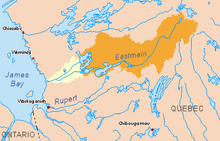 Eastmain River original basin in yellow and orange. Diverted basin in orange. | |
| Location | |
| Country | Canada |
| Province | Quebec |
| Region | Jamésie |
| Physical characteristics | |
| Source | Lac Bréhat |
| • location | Baie-James, Nord-du-Québec, Québec, Canada |
| • coordinates | 52°31′30″N 70°52′00″W |
| • elevation | 554 m (1,818 ft) |
| Mouth | James Bay |
• location | Eastmain, Nord-du-Québec, Quebec, Canada |
• coordinates | 52°14′30″N 78°34′00″W |
• elevation | 0 m (0 ft) |
| Length | 756 km (470 mi)[1] |
| Basin size | 46,400 km2 (17,900 sq mi)[1] |
| Discharge | |
| • average | 930 m3/s (33,000 cu ft/s)[1] |
| Basin features | |
| Tributaries | |
| • left |
|
| • right |
|
Name
Eastmain is a compounding of the river's former name East Main,[2] which was taken from the former Hudson's Bay Company outpost at its mouth, which controlled the its operations in the East Main District on the eastern side of James Bay.
Geography
Since the late 1980s, most of the waters of the Eastmain River have been diverted and flow northwards through the Opinaca Reservoir, with a surface area of about 950 km2, and into the Robert-Bourassa Reservoir of Hydro-Québec's La Grande Complex. The remainder of the Eastmain River contains only about 10% of the volume of its former flow, and is now subject to freeze-up in winter (see photo). These changes have affected the Cree and Inuit peoples who live along the Eastmain River and James Bay coast.

A further hydroelectric project on the upper Eastmain River was under construction in 2005. The project was part of the original hydroelectric project provided for by the James Bay and Northern Quebec Agreement of 1975. The Eastmain Reservoir will eventually have a surface area of about 600 km2 and the Eastmain-1 power plant will generate a maximum of 900 MW.

History
The mouth of the Eastmain was a centre of the Hudson Bay Company fur trade. Charles Bayly reached it from Rupert House in the 1670s. After Rupert House was destroyed in 1686, the area was visited by a ship from York Factory. In 1723 to 1724, Joseph Myatt of the Hudson's Bay Company built a post.[3]
See also
- Centrale Eastmain-1
- James Bay Project
- Jamésie
- List of rivers of Quebec
- List of longest rivers of Canada
References
- Atlas of Canada Archived February 2, 2007, at the Wayback Machine (all values of original river prior to hydro-electric development.)
- Low, Albert Peter (1896), Report on Explorations in the Labrador Peninsula along the East Main, Koksoak, Hamilton, Manicuagan, and Portions of Other Rivers in 1892-93-94-95, Geological Survey of Canada, Ottawa: S.E. Dawson.
- Arthur S Morton, A History of the Canadian West to 1870-71, no date, circa 1950
| Authority control: National libraries |
|---|
На других языках
[de] Rivière Eastmain
Der Rivière Eastmain ist ein Zufluss der James Bay im Westen der kanadischen Provinz Québec.- [en] Eastmain River
[es] Río Eastmain
El río Eastmain (en francés: Rivière de l'Eastmain); en inglés, Eastmain River es un río de la vertiente Ártica de Canadá que discurre por la parte noroccidental de la provincia de Québec. Nace en el Quebec centroseptentrional y fluye a lo largo de 756 kilómetros,[1] hacia el oeste, para acabar desembocar en la bahía de James. Drena una cuenca de 46.400 km²,[1] mayor que países como Estonia, Suiza o los Países Bajos.[it] Eastmain
Il 'fiume Eastmain' (in inglese Eastmain River) è un fiume canadese situato nel Nord del Quebec.[ru] Истмейн (река)
Истмейн (фр. Rivière de l'Eastmain; англ. Eastmain River) — река в северо-западном Квебеке. Длина 756 км, истоки находятся в центре провинции, а впадает река в залив Джеймс. Истмейн — англ. East Main — восточный Мейн — старое название восточной части залива Джеймс. Площадь водосборного бассейна — 46400 км². В сть реки находится деревня Истмейн индейского народа кри[1].Другой контент может иметь иную лицензию. Перед использованием материалов сайта WikiSort.org внимательно изучите правила лицензирования конкретных элементов наполнения сайта.
WikiSort.org - проект по пересортировке и дополнению контента Википедии