geo.wikisort.org - River
The Likouala-Mossaka (or Likouala River) is a river in the Republic of the Congo. It is a tributary of the Congo River, which it enters to the east of the town of Mossaka.
| Likouala-Mossaka | |
|---|---|
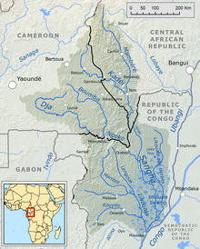 Sangha River basin, showing the Likouala to the west | |
 | |
| Location | |
| Country | Republic of the Congo |
| Physical characteristics | |
| Mouth | Congo River |
• location | Mossaka |
• coordinates | 1.2270°S 16.7991°E |
Location
The Likouala-Mossaka is a right tributary of the Congo into which it flows at Mossaka about 650 kilometres (400 mi) from its source. Its basin adjoins that of the Sangha River to the north and the Ogooué River in Gabon to the west. To the south it adjoins the basin of the Alima, which has hardly any left tributaries.[1] The lower Sangha, the Likouala-aux-Herbes and Likouala-Mossaka rivers flow through the Congolese Cuvette, a huge depression with an equatorial climate. The soil of this region is sandy or clayey quaternary fluvial alluvia. Vegetation is dense, humid, shady forest that partly floods during the high water season.[2]
Hydrology
Between 1951 and 1993 annual rainfall in the Likouala-Mossaka basin was 1,689 millimetres (66.5 in) and average discharge at the Makoua gauging station was 216 cubic metres per second (7,600 cu ft/s).[3] The basin above this point covered 14,100 square kilometres (5,400 sq mi).[4]
European exploration
Pierre Savorgnan de Brazza explored the upper part of the Likouala-Mossaka, the Licona, in August 1878. Albert Dolisie entered its mouth in 1884. Giacomo Savorgnan di Brazzà descended the river when he returned from his exploration of the north in December 1885. In 1899 the whole Likouala-Mossaka basin was granted to the Tréchot brothers who had created the Compagnie Française du Haut-Congo (CFHC) for its operation.[1] In 1908 there were four administrative posts in a territory of about 80,000 square kilometres (31,000 sq mi). Seventy-two villages had to pay 44,648 francs in taxes.[5] Until 1909 the French administration of the Likouala-Mossaka basin was very light, and little had been done to develop its resources.[6]
Notes
- Mazenot 1966, p. 268.
- LaraqueMahé, Orange & Marieu 2001, p. 107.
- LaraqueMahé, Orange & Marieu 2001, p. 113.
- LaraqueMahé, Orange & Marieu 2001, p. 106.
- Mazenot 1966, p. 270.
- Mazenot 1966, p. 269.
Sources
- Laraque, Alain; Mahé, Gil; Orange, Didier; Marieu, Bertrand (2001), "Spatiotemporal variations in hydrological regimes within Central Africa during the XXth century" (PDF), Journal of Hydrology (245): 104–117, retrieved 2021-10-19
- Mazenot, Georges (1966), "L'occupation du Bassin de la Likouala-Mossaka 1909-1914" (PDF), Cahiers d'études africaines, 6 (22): 268–307, doi:10.3406/cea.1966.3067, retrieved 2021-10-20
| Authority control |
|
|---|
На других языках
[de] Likouala-Mossaka
Die Likouala-Mossaka ist ein etwa 490 km (einschließlich Quellflüssen 615 km) langer rechter Nebenfluss des Kongo im Westen der Republik Kongo. Das Einzugsgebiet umfasst eine Fläche von 69.800 km².[1] Der Fluss trägt den Namenszusatz Mossaka zur Unterscheidung von dem ähnlich benannten Fluss Likouala-aux-Herbes, ein Nebenfluss der Sangha, der weiter östlich verläuft.- [en] Likouala-Mossaka
Другой контент может иметь иную лицензию. Перед использованием материалов сайта WikiSort.org внимательно изучите правила лицензирования конкретных элементов наполнения сайта.
WikiSort.org - проект по пересортировке и дополнению контента Википедии