geo.wikisort.org - River
The Kouilou-Niari River—also spelled Kwilu, Kwila, or Kwil—is the most important river flowing to the Atlantic Ocean of the Republic of the Congo coast. Moreover, its entire drainage area is completely in the Republic of the Congo. The river is called the Kouilou River while flowing in the coastal region of the Kouilou till the Sounda gorges. Upstream from the gorges, its name is the Niari River and it flows through the Niari Valley. The river combines with the Louessé, the Loudima and the Bouenza River and eventually flows into the Atlantic Ocean. It covers about 560 km from its origin in the Batéké Plateau of the Congo to its mouth at the coast.
This article may be expanded with text translated from the corresponding article in French. (September 2012) Click [show] for important translation instructions.
|
This article needs additional citations for verification. (February 2013) |
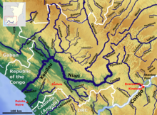
The river has numerous waterfalls and is impassable from its mouth, which is of difficult access by multiple sandbars, formed primarily by the action of the Benguela current. The river is usable and boats are coming up to Kakamoéka. From Kakamoéka to Sounda, rapids and rocks are blocking access especially during dry season. Very limited traffic upstream Sounda as they are rapids and a few bridges.
Bridges on the river are located at Bas-Kouilou, Sounda, Kimbangou, Makabana, Loudima and Bouenza.
The Kouilou part is fairly flat with the water level rising only 16 metres above sea level on first 70 km. In the area of Kimbangou, the water level is around 60 metres above sea level and reaches 115 metres at the Loudima junction.
List of waterfalls
- Zrinski chutes: Honors Nikola Zrinski and Petar Zrinski, Croatian nobles; "discovered" and named in 1882 by a Croatian member (Dragutin Lerman) of Henry Morton Stanley's exploration team. Local names, and local knowledge in general, are unfortunately ignored in such naming.
- Sounda gorges. The gorges are remarkable with a small waterdrop of two metres and mountain around 120 metres high. An old iron bridge is still usable in 2012 to cross the river in Sounda. A road comes from the village of Mandzi south of Sounda while the road continues on north west toward Kakamoéka, sous-prefecture. An abandoned track on the southern bank of the river reaches Kakamoéka which was created during the exploration for the train. The mission Jacob[1] was conducted in 1896. The track was reopened in 1954 for the evaluation of the hydro potential of the Sounda dam.[2]
In Sounda, a large hydro electrical project has been evaluated since the mid 1950s when France was looking at developing the region. Ten years of research have led to a tunnel built in the mountain, a bridge and a camp established on site.
In May 2011, a protocole d'accord has been signed with a South African Company IDG and the Republic of Congo for the development of the Sounda dam project.[3] IDG has teamed up with strategic partner African Power Corporation (APC). The two companies have joined forces to lead the development of the project. Coming together with the potential users and financial institution to put the project on track for success. Such a project is expected to help develop the country's huge mineral potential. In October 2012, APC increased their presence in the country and name a country representative.[4] Nicolas Rouzé has a great experience in the Congo as he has been in country since 1998. He is managing the efforts in the country to drive the project on the local scale.
Notes and references
- "French national library".
- "Institut de recherche et de developpement".
- "IDG eyes Congo hydro dam". Reuters. Retrieved 9 May 2011.
- "APC African Power Corporation -the team". Retrieved 21 Nov 2012.
Annex
Nicolas Tourot, Les Projets de développement hydroélectrique en Afrique noire, mémoire de maîtrise, Paris I, 2003 EDF, études préliminaires du site hydroélectrique de Sounda, 1954.
Articles
- Expéditions préludes à la fondation de l'État indépendant du Congo
- Le chemin de fer Congo-Océan
External links
- Le projet de construction d'un barrage sur le Kouilou-Niari
- African Power Corporation Website
- Institut de Recherche et Développement Website
Authority control | |
|---|---|
| General |
|
| National libraries | |
На других языках
[de] Kouilou (Fluss)
Der Kouilou, dessen Name auch Kwilu, Kwila, oder Kwil geschrieben wird, ist der größte Fluss in der Republik Kongo.- [en] Kouilou-Niari River
[es] Río Kouilou-Niari
El río Kouilou-Niari— también llamado Kwilu, Kwila, y Kwil— es el río más importante de la República del Congo. El río se llama Kouilou durante la mayor parte del recorrido, pero en su sección central, en la región de Niari, se conoce como río Niari. El río se combina con el Louessé y vierte sus aguas en el océano Atlántico. Recorre unos 700 kilómetros desde su nacimiento en la meseta del Congo hasta su desembocadura.[ru] Куилу (река)
Куи́лу, Кви́лу (фр. Kouilou) — река в Республике Конго. В среднем течении называется Ниари. Протекает по территории департаментов Ниари и Куилу, названных по реке, а также по департаменту Буэнза и по границе департамента Лекуму.Другой контент может иметь иную лицензию. Перед использованием материалов сайта WikiSort.org внимательно изучите правила лицензирования конкретных элементов наполнения сайта.
WikiSort.org - проект по пересортировке и дополнению контента Википедии