geo.wikisort.org - River
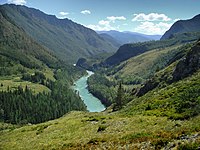
The Katun (Russian: Катунь, Katuń; Altay: Кадын, Kadyn) is a river in the Altai Republic and the Altai Krai of Russia. It forms the Ob as it joins the Biya some 19 kilometres (12 mi) southwest of Biysk.[3] The Katun is 688 kilometres (428 mi) long, and its drainage basin covers 60,900 square kilometres (23,500 sq mi).[4] It originates in the Katun glaciers on the southwestern slope of Belukha Mountain. The river freezes up in late November or early December and breaks up in early or mid-April. The main tributaries of the Katun are, from source to mouth: Koksa (left), Kucherla (right), Argut (right), Chuya (right), Ursul (left), Sema (left) and Isha (right). The river is navigable.

This article needs additional citations for verification. (December 2009) |
| Katun | |
|---|---|
 The Katun in Tyungur village | |
| Etymology | "woman", Altay language |
| Native name | Катунь (Russian) |
| Location | |
| Country | Russia |
| Region | Altai Republic, Altai Krai |
| Physical characteristics | |
| Source | Katun Glacier |
| • location | Belukha Mountain, Altai Republic |
| • coordinates | 49.7635°N 86.564°E |
| • elevation | 2,300 m (7,500 ft) |
| Mouth | Ob |
• location | Confluence with Biya, near Biysk, Altai Krai |
• coordinates | 52°25′54″N 85°01′26″E |
• elevation | 195 m (640 ft) |
| Length | 688 km (428 mi) |
| Basin size | 60,900 km2 (23,500 sq mi) |
| Discharge | |
| • location | Srostki, 58 kilometres (36 mi) from the mouth[1] |
| • average | 617 m3/s (21,800 cu ft/s)[2] |
| • minimum | 16 m3/s (570 cu ft/s) |
| • maximum | 2,930 m3/s (103,000 cu ft/s) |
| Basin features | |
| Progression | Ob→ Kara Sea |
| Tributaries | |
| • left | Koksa, Ursul, Kamenka |
| • right | Kucherla, Argut, Chuya, Isha |
In its upper reach of the Katun flows down the distant and sparsely populated area, but a few kilometers downstream near the village Kuyus, the coastal population density grows steadily and the area downstream of the village Ust-Sema is the most populated. There are numerous buildings, holiday camps and various guest houses in the pine forest near the village. The main settlements along the Katun are, from source to mouth: Ust-Koksa, Katanda, Inya, Chemal, Manzherok, Souzga, Aya, Mayma, Srostki and Verkh-Katunskoye.
See also
- Altai flood
References
- "Katun River discharge at Srostki". Soviet Union Hydro-Station archive. UNESCO. 1936–1990. Archived from the original on 2009-11-25. Retrieved 2010-11-12.
- "Katun River discharge at Srostki". Soviet Union Hydro-Station archive. UNESCO. 1936–1990. Archived from the original on 2009-11-25. Retrieved 2010-11-12.
- Катунь, Great Soviet Encyclopedia
- "Река БИЯ in the State Water Register of Russia". textual.ru (in Russian)., erroneously named "БИЯ"
На других языках
[de] Katun
Der Katun (russisch Катунь) ist der 688 km lange linke Quellfluss des Ob im Süden von Westsibirien (Russland). Es ist auch namensgebend für die von ihm auf drei Seiten umrundete Katun-Kette im Zentrum des Hohen Altai oder Russischen Altai.- [en] Katun (river)
[es] Río Katún
El río Katún (en ruso: Река Катунь (en altái: Кадын Kadyn)) es un río de la parte meridional de la Siberia Occidental rusa, una de las fuentes del río Obi. Su curso tiene una longitud de 688 km y drena una cuenca de 60.950 km² (mayor que países como Togo o Croacia).[it] Katun'
Il Katun' (in russo: Катунь?; anche traslitterato come Katun) è un fiume della Russia siberiana sudoccidentale (Repubblica dell'Altaj e Territorio dell'Altaj), ramo sorgentifero di sinistra dell'Ob'.[ru] Катунь
Кату́нь[2] (южно-алт. Кадын) — река в Республике Алтай и Алтайском крае России, левая и главная составляющая Оби (правая — Бия). Длина реки — 688 км[3]. Площадь бассейна — 60 900 км²[3].Другой контент может иметь иную лицензию. Перед использованием материалов сайта WikiSort.org внимательно изучите правила лицензирования конкретных элементов наполнения сайта.
WikiSort.org - проект по пересортировке и дополнению контента Википедии